
Map State West Sheet, W 1840/1
Australia from surveys made by order of the British Government
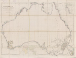
AUSTRALIA FROM SURVEYS MADE BY ORDER OF THE BRITISH GOVERNMENT COMBINED WITH THOSE OF D'ENTRECASTEAUX, BAUDIN, FREYCINET, &c, &c BY JOHN ARROWSMITH. 1840. London, Pub'd. 1st May 1840, by John Arrowsmith, 35 Essex Street, Strand.
[WEST SHEET] Extent E 112° TO E 137°30'
OVERLAP
The sheets are designed to be joined along E 134°. On the west sheet the area between E 134°and E 137°30' is not fully updated
INSET:
Bottom right. [Eastern hemisphere]
Description
Shows
TITLE:
The date in the title reads 1840
IMPRINT:
The imprint is dated 1st May 1840
In the 1840/1state of the map some issues of Arrowsmith's imprint have been pasted over with a label reading "G.Cruchley, Map Seller & Publisher, 81 Fleet Street from 38 Ludgate Street London" [n.d.] .
COLONIES:
SOUTH AUSTRALIA, WESTERN AUSTRALIA
REGIONS:
ARNHEM LAND, TASMAN LAND, DAMPIER LAND, DE WITT LAND, ENDRAGT LAND, EDEL LAND, VLAMING LAND, LEEUWIN LAND, NUYTS LAND.
COUNTIES: WESTERN AUSTRALIA
The number of counties has been increased to 26 which are now numbered and listed in table bottom left.
BOUNDARIES:
The boundary between New South Wales and Western Australia shown at 129°E. The territorial limits of the Colony of Western Australia first formally defined by Letters patent dated 4th March 1831. Prior to that date the western boundary of New South Wales was by Letters patent of 6th July 1825, proclaimed at Sydney 20th Dec. 1825 extended to 129°E).
The western boundary of South Australia is shown at 132°E declared on 28th December 1836. (McLelland, M. H. 1971, p. 672-4, 677)
EXPLORERS:
Lt. George Grey and Franklin Lushington Dec. 1837- April 1838, John Lort Stokes 1837-40.
NOTES ON COASTS
See West 1838/1
REFERENCE:
Not in Tooley
NOTES
Northern Territory
In the 1840/1 state of the map Victoria is inserted on the Coburg Peninsula. Coburg Peninsula is shortened to Coburg Pa.
Western Australia
The first 1838 issue of the map is notable for its blank interior. Almost all the information is coastal in nature except for the south-west corner of the continent.
In the 1839/1(1838/2) state of the map the name WESTERN AUSTRALIA has been added to the map. Fifteen counties are named and delimited on the map with the exception of Kent which lacks northern and eastern limits.
Also in this state of the map new names appear from Lieut. Lort Stokes survey in King Sound. He has renamed the Sound in honour of Phillip Parker King who had previously named it Cygnet Bay. The following names appear; Beagle Bay, King Sound, Roe's I., Hope Inlet, Disaster B. Valentine I., Fitzroy R., Mary I., Pt. Torment, Stokes Bay and Port Usborne. (Hordern, Marsden 1989, p.62, 63 map, 72 and 82 and loose map)
Names appear following George Grey's expedition to Hanover Sound (Dec.1837) accompanied by five men one of whom was his close friend Lt. Franklin Lushington. The course of the Glenelg River appears and also shown are Lushington's farthest and Lt. Grey's farthest. (Cannon, Michael 1987, p. 186)
In the 1840/1 state of the map the number of counties has been increased to 26 names which are now numbered and listed separately in a table. This state shows the increase in knowledge of the area east and south of Perth.
An explorer's track is shown east of Perth to Lake Brown and then west to the Moore River. The northern boundary of Twiss County has been adjusted southwards.
Moving down the west coast on the land opposite Jurien Bay a note appears Three rocky hillocks on the ridge.
Also in the 1840/1 state of the map in King Sound the following names have been added from Lort Stokes work on this coast in the Beagle during 1838; Cone Bay, Saddle Hill and Compass Hill on the eastern shoreline. Stephen Ra is inserted across the mouth of the Glenelg R. Relief now shown by hachures.(Cannon, Michael 1987, p. 186)
In the area where the Fitzroy R. debouches into King Sd. is found the comment Thick forest, trees large, further east at Collier Bay two comments have been removed from the hinterland of Collier Bay and the coastline now appears in a firm line rather than a dotted line. The names Doubtful Bay inserted above Collier Bay and Slate Is. (nr. Camden Sound). (Hordern, Marsden 1989, p.62, 63 map, 72, 77 map, and 82)
New developments are shown as far east as almost 119°E.
Changes AND ADDITIONS
TITLE:
The date in the title now reads 1840.
IMPRINT:
The imprint is updated to 1st May 1840. On some issues Arrowsmith's imprint has been pasted over with a label reading "G.Cruchley, Map Seller & Publisher, 81 Fleet Street from 38 Ludgate Street London" [n.d.]
COUNTIES:
The names of the counties have been removed from the map, numbered and listed in a marginal table.
NOTES
Northern Territory
Victoria is inserted on the Coburg Peninsula. Coburg Peninsula is shortened to Coburg Pa.
Western Australia
This state shows the increase in knowledge of the area east and south of Perth. An explorer's track is shown east of Perth to Lake Brown and then west to the Moore River. The northern boundary of Twiss County has been adjusted southwards. The most obvious change is the increase in the number of counties in Western Australia which is now shown as 26.
In the west Kimberley area in King Sound the following names have been added from Lort Stokes work on this coast in the Beagle during 1838; Cone Bay, Saddle Hill and Compass Hill on the eastern shoreline .In the area where the Fitzroy R. (named by Stokes for Robert Fitzroy) debouches into King Sd. is found the comment Thick forest, trees large, further east at Collier Bay two comments have been removed from the hinterland of Collier Bay and the coastline now appears in a firm line rather than a dotted line. The names Doubtful Bay inserted above Collier Bay and Slate Is. (nr. Camden Sound). (Hordern, Marsden 1989, p.62, 63 map, 72 and 82 and loose map)
Names appear following George Grey's expedition to Hanover Sound (Dec.1837) accompanied by five men one of whom was his close friend Lt. Franklin Lushington. Stephen Ra is inserted across the mouth of the Glenelg R. Relief is now indicated by hachuring. (Cannon, Michael 1987, p. 186)
Moving down the west coast on the land opposite Jurien Bay a note appears Three rocky hillocks on the ridge.
New developments are shown as far east as almost 119°E.
Key Dates
- 1616 - 1840
- Situation date
- May 1840
- Map Publication Date
Original sources
Hydrographic Office (UK)
Charts
Cape Leveque to White I. incl. Buccaneer Archo, Collier Bay ca. 1:280 000. Com. J. L. Stokes L2363 1838
Cape Leveque to Buccaneer Archo -King Sd. Entrance ca. 1:145 000 Com. J. L. Stokes L2363d 1840.
Related entries
Timeline
West Sheet, W 1838/1
West Sheet, W 1839/1 (1838/2)
West Sheet, W 1840/1
West Sheet, W 1840/2
West Sheet, W 1840/3
West Sheet, W 1841/1
West Sheet, W 1842/1
West Sheet, W 1846/1
West Sheet, W 1847/1
West Sheet, W 1850/1 (1848/1)
West Sheet, W 1850/2 (1850/1)
West Sheet, W 1850/3 (1853/1)
West Sheet, W 1856/1
West Sheet, W 1858/1
West Sheet, W 1862/1
West Sheet, W 1862/2
Australia [West Sheet], W 1884/1
Australia [West Sheet], W 1887/1
Institutional and Other Holdings
National Library of Australia Map Collection
- Australia from surveys made by order of the British Government [cartographic material] : combined with those of D'Entrecasteaux, Baudin, Freycinet &c. &c. / by John Arrowsmith, MAP RM 4250; National Library of Australia Map Collection. Details
State Library of Western Australia
- Australia from surveys made by order of the British Government, combined with those of D'Entrecasteaux, Baudin, Freycinet &c. &c. [cartographic material] / by John Arrowsmith, 1840., 3rd Floor Map Stack 24/4/4 RARE; State Library of Western Australia. Details
Published resources
Books
- Cannon, Michael, The exploration of Australia, Reader's Digest, Sydney, 1987, 304 pp. Details
- Hordern, Marsden, Mariners are warned! : John Lort Stokes and H.M.S. Beagle in Australia 1837-1843, Melbourne University Press at the Miegunyah Press, Carlton, Victoria, 1989, 359 pp. Details
- Tooley, Ronald Vere, The mapping of Australia and Antarctica, Holland Press, London, 1985, 649 pp. Details
Journal Articles
- McClelland, M. H., 'Colonial and state boundaries in Australia', The Australian Law Journal, vol. 45, November 1971, p. 679. Details
Images
Dorothy F. Prescott
Created: 10 January 2012, Last modified: 7 August 2012