
Map State The Colony of Western Australia, 1863/1
The Colony of Western Australia; from the surveys of John Septimus Roe, Esqr. , Surveyor Genl. and from other Official Documents in the Colonial Office and Admiralty, compiled by John Arrowsmith. [Pl. 36] Scale [ca. 1:970 000 at 35°S]. S 30° 57'-S 35° 07'/E 113° 40'-E 123° 50'. London, Pubd. Jany. 2nd 1863 by J. Arrowsmith, 35 Hereford Sq. Sth. Kensington.
1 map : col., dissected and mounted on linen ; 50.0 x 98.5 cm.
Insets: Guildford, Kelmscott, Augusta, Perth, Fremantle
Description
Now shows 26 counties in the south-western portion of the Colony with explorers' tracks and profuse notes on landscape and vegetation. Some landholders identified.
PLATE NO:
None
CO-ORDINATES:
These have been changed and are now S30°57'-S 35°07'/E113°40'-E123°50'
IMPRINT:
The imprint reads London, Pubd. Jany. 2nd 1863 by J. Arrowsmith, 35 Hereford Sq. Sth. Kensington.
PHYSICAL EXTENT:
1 map : col. ; 50 x 98.5cm. The map has a further 36 cm. added to its width.
INSETS:
Guildford, Augusta, Kelmscott, Perth, Fremantle
Guildford
North-east of Perth shows landholders W. Tanner and J. Stirling north of the Swan River and to the west of the Swan, W. Tanner, S. Dodds, F. H. Byrne, Capt. Picking and N. S. Talbot. The Helena River flows into the Swan from the east. Public buildings and streets named.
Augusta
Plan of the town at the mouth of the Blackwood River land allotments shown fronting Flinders Bay.
Kelmscott
Plan of the settlement shown on the right bank of the Canning River with allotments laid out along the river bank.
Perth
Town plan shows allotments fronting the Swan River. St Georges Terrace named. Large areas of swamps behind the front streets overlie allotments. To the east along the right bank of the Swan are land holdings in the names of P. Brown, W. T. Graham, A. H. Stone, W. B. Andrews and P. Wicks. A burial ground is marked east of the town.
Fremantle
Town plan with streets and land allotments laid out and public areas designated.
COUNTIES:
MELBOURNE, GLENELG, GREY, CARNARVON, LANSDOWNE, DURHAM, VICTORIA, TWISS, PERTH, YORK, HOWICK, BEAUFORT, MINTO, GRANTHAM, MURRAY, WELLINGTON, WICKLOW, PEEL, HAY, GODERICH, NELSON, SUSSEX, LANARK, STIRLING, PLANTAGENET AND KENT
EXPLORERS' ROUTES:
Shows the routes of Lt. W[illiam] Preston, Dr. A[lexander] Collie, Ens. Robert Dale, Lt. A. Erskine, Capt. M[ark] J[ohn] Currie, Govr. James Stirling, J[ohn] S[eptimus] Roe, J[ohn] G[arrett] Bussell, Dr. T[homas] B[raidwood] Wilson, G[eorge] F[letcher] Moore, G. F. Moore and Brown [Peter Broun] (A.D.B. 1788-1850, v. 1, p. 165), Lt. [Henry William St Pierre] Bunbury and A[lfred] Hillman.
REFERENCE
Not in Tooley
NOTES
The Discoveries map which was the earlier state of this new title has been extensively revised and includes many new place names including places such as Rockingham, Pinjarra, Picton, Bunbury and Busselton on the west coast. On the south coast Normalup, Rame Hd., Irwin Inlet, Dillon Bay, Bremer Bay and Pt. Hood among others. New rivers flowing to the sea are the Lennox, Vasse and Capel into Geographe Bay and the estuary of an un-named river east of Pt. Knob. Rugged ranges north of Abany are now named the Stirling Ranges.
The coast line has been greatly altered and many new features are named.
Land allotments appear in the Swan, Avon and Toodyoy valleys, near Pinjarra and the Murray River, on the west coast at Busselton and near Picton, waterloo and Williamsburg. Other blocks are shown near Albany and Wyndham and in the Vale of Kalgan.
New discoveries include the tracks of A. Collie in 1832 up a tributary of the Swan River and back via the Swan, this possibly being an examination of the 1500 acres granted to him.
G. F. Moore's May 1836 explorations are shown north from Guildford to the Moore R. then south-west following the river and thence south-east back to Guildford. A second exploration is shown north-east of Guildford to Northam and beyond with Brown [Peter Broun] in 1836.
J. S. Roe's journey is shown from Albany west and then north-east before turning north-west in Nov and Dec.1835. Pushing inland J. S. Roe's track appears Oct/Nov 1836 east of Perth from York to the Glenelg Hills thence north to latitude 31°45'S and from thence westward to the Moore R and thence southward to Guildford.
Tracks of Lt. Bunbury in Oct 1836 between Beverley and Williamsburg shown.
A. Hillman's tracks from Pinjarra on the west coast eastward to Williamsburg in January 1835 appear, and his route west of Albany towards Pt Nuyts in July 1833.
Lt. W. Preston's track is shown from Augusta to the north in vicinity of Vasse Inlet in 1831.
The supposed track of convicts overland from Albany to Geographe Bay has been removed.
There were no changes to the map content of the 1839 issues after the first.
In the 1843/1 state of the map the previously unnamed river west of Kojanup (33°50'S/ 117°09'E) now called Balgarup R. Kinnunup appears on Roe's 1835 north/south return track. A. Hillman's track completed from north of Williamsburg returning to Pinjarra in Oct 1835.
A. Collie's April 1831 exploration shown by a loop north-west of Wyndham and north of the Vale of Kalgan.
L. Preston appears on the coast north of the County of Wellington. The outline of Australind is shown west of Waterloo on the Leschenault Inlet. The R. Preston which drains the Henty Plains now shown as the most southerly of three streams flowing north-west to Picton (previously the next most northerly had carried this name). Dalyellup appears on the coast near Picton and Bunbury's Ford further south.
Stirling and Roe's journey down the west coast between Peel Inlet and Vasse Inlet marked.
The course of the R. Capel is changed. New mid sections of other rivers in this vicinity appear. A track from Vasse Inlet marked going east to Henty Plains and then north-west to Bunbury is shown.
Also an undated track is shown for Sir James Stirling just south of Bunbury.
In the 1856/1 state there were extensive alterations and additions. The large inset of the Perth region at the right centre of the map has been removed in order to accommodate Roe's explorations of 1848-1849. The map does not extend far enough to the east to show the full extent of his explorations.
In the north-west of the map the Moore R. has been traced downstream to the west coast.
A track is shown from the south coast east of Pt. Nuyts which proceeds north to Kojanup.
The eastern part of Wellington County has much extra information.
The undated track going north-west to Bunbury now labelled 'Roe 1829'. It appeared from between the headwaters of the Collie River and the Blackwood River.
In Nelson County, the Blackwood R. has been traced eastward and links up with the Balgarup R., Beaufort and Hillman rivers which appear to be tributaries of the Blackwood. Blocks of land appear on the Balgarup in the vicinity of Kojanup.
The most significant changes relate to Roe's 1848 and 1849 explorations east of longitude 118°E travelling south and east from Perth and York to the Pallinup R. and then north- east from the Pallinup R. Towards the Ravensthorpe Hills and into the interior. The Salt R. shown in the 1843/1 state with a supposed course is now shown from its mouth near Pt. Irby to north of the Stirling Ranges. Its name is now the Pallinup R. The river is traced almost to the point of Roe and Stirling's previous exploration of 1835. Roe's track also appears along the southern coastline between Cheyne Inlet and Fitzgerald Inlet (119°30'E).
The exploration track by Bannister in February 1831, from Perth to the south coast near Pt. Nuyts has been removed.
The 1856/2 state of the map is identical to the previously undated issue i.e. 1856/1(undated) except that the imprint has been updated to 'Jan.2nd 1856'.
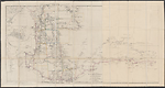
In the final state of this map 1863/1 the south coast is now extended eastwards to Cape Pasley at 123°40'E. The Archipelago of the Recherche is named. Inland of this coast the farthest northerly features are the Dundas Hills. There are many salt lakes marked. Roe's route in 1848-49 is marked as far east as the Russell Range returning west on a track closer to the coast. This is the last state of the map produced by Arrowsmith.
CHANGES AND ADDITIONS
PLATE NO:
The plate number has been removed. The map is unfinished to the extent that its top border line is incomplete and the degree values have not been added.
COORDINATES:
The map has been extended to 123°40'E
IMPRINT:
The imprint reads London, Pubd. Jany. 2nd 1863 by J. Arrowsmith, 35 Hereford Sq. Sth. Kensington.
PHYSICAL EXTENT:
The sheet has been physically enlarged to measure 50.0 x 98.5cm., another 36 cm. in width, permitting almost a further 4 degrees of longitude to be added.
EXPLORER'S ROUTES:
J. S. Roe's route east to the Russell Range in 1848-49 appears.
NOTES
The south coast is now extended eastwards to Cape Pasley at 123°40'E. The Archipelago of the Recherche is named. Inland of this coast the farthest northerly features are the Dundas Hills. There are many salt lakes marked. Roe's route in 1848-49 is marked as far east as the Russell Range returning west on a track closer to the coast. This is the last state of the map produced by Arrowsmith.
Key Dates
- 1829 - 1862
- Situation date
- 2 January 1863
- Map Publication Date
Related entries
Timeline
Discoveries in Western Australia, 1833/1
Discoveries in Western Australia, 1833/2
Discoveries in Western Australia, 1833/3
Discoveries in Western Australia, 1833/4
Discoveries in Western Australia, 1833/5 (1834)
Discoveries in Western Australia, 1833/6 (1838/1)
Discoveries in Western Australia, 1833/7 (1838/2)
The Colony of Western Australia, 1839/1
The Colony of Western Australia, 1839/2
The Colony of Western Australia, 1839/3
The Colony of Western Australia, 1839/4 (1842/1)
The Colony of Western Australia, 1843/1
The Colony of Western Australia, 1856/1 (no date)
The Colony of Western Australia, 1856/2
The Colony of Western Australia, 1863/1
Institutional and Other Holdings
National Library of Australia Map Collection
- The Colony of Western Australia [cartographic material] : from the surveys of John Septimus Roe Esqr. Surveyor Genl. and from other official documents in the Colonial Office and Admiralty / compiled by John Arrowsmith, MAP RM 1192; National Library of Australia Map Collection. Details
Published resources
Books
- Tooley, Ronald Vere, The mapping of Australia and Antarctica, Holland Press, London, 1985, 649 pp. Details
Images
- Title
- The Colony of Western Australia, 1863/1
- Type
- Map
- Repository
- National Library of Australia Map Collection
Dorothy F. Prescott
Created: 3 August 2010, Last modified: 7 August 2012