
Map State [Australia, East], 1884/1
Stanford's London Atlas of Universal Geography
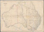
[AUSTRALIA, EASTERN]. Scale ca. 1: 5 068 800.
London: Published by Edward Stanford, 55 Charing Cross, March 20th 1884. Stanford's Geogl. Estabt., 55 Charing Cross.
EAST SHEET Extent E130° to E156°
OVERLAP
The overlap of east and west sheets occurs from longitude E 130°- E137°. The joining line for the two sheets is E134°. Information in the area E134° to E137° is not fully updated on the east sheet indicating that the cartographer had designed the map in two sheets to be joined.
Description
Shows:
TITLE:
None
PLATE NO:
Listed in Atlas Contents only but not on map as [67]
SCALE:
Appears in the lower left hand corner where the Arrowsmith title was located
LEGEND:
A short legend showing roads, railways, telegraph lines, tracks of travellers and numbered heights, appears lower left.
IMPRINT:
The publisher is shown as Edward Stanford, the address now reads '55 Charing Cross' and the date of publication is changed to 'March 20th 1884'. The position of the imprint remains beneath the lower neat lines, centre and right.
COLONIES:
QUEENSLAND, NEW SOUTH WALES, VICTORIA, SOUTH AUSTRALIA
REGIONS:
CAPE YORK PENINSULA, Yorke Peninsula
COUNTIES: (NORTHERN TERRITORY)
PALMERSTON, DISRAELI, GLADSTONE
PASTORAL DISTRICTS: (QUEENSLAND)
COOK, NORTH KENNEDY, BURKE, SOUTH KENNEDY, MITCHELL, NORTH GREGORY, SOUTH GREGORY, WARREGO, MARANOA, LEICHHARDT, BURNETT, PORT CURTIS, WIDE BAY, MORETON, DARLING DOWNS
PASTORAL DISTRICTS: (NEW SOUTH WALES)
CLARENCE, GWYDIR, MACLEAY, NEW ENGLAND, LIVERPOOL PLAINS, WARREGO, BLIGH, WELLINGTON, LACHLAN, ALBERT, DARLING, MURRUMBIDGEE and MONARO
SQUATTING DISTRICTS: (VICTORIA)
WIMMERA, LODDON, MURRAY and GIPPSLAND
EXPLORERS:
Robert Dixon 1833, Edmund Kennedy 1848, John McDouall Stuart 1858, 1861, 1862 , William Landsborough 1861, Ernest Giles 1872 & 74, William Harry Tietkens and Jesse Young 1875, John Ross 1870 and William Harvey, surveyor, 1870.
COASTS:
PACIFIC OCEAN now appears top right hand side of map and lower bottom, with INDIAN OCEAN located under South Australian coastline.
REFERENCE:
Herbert, Francis (1989) The 'London Atlas…' pp. 106-109.
NOTES
Northern Territory
Only a small portion of the map remains blank in the eastern part of the Northern Territory. The greater part of the most recent exploration is confined to the vicinity of the Overland Telegraph between Adelaide and Palmerston and in the McDonnell and James Ranges area. Note on Permanent water, Ross and Harvey appears on the Todd River (24°S/135°E) Ross was leader of an Expedition to find the best route for the Overland Telegraph in 1870, Harvey was the second in command.
The Overland Telegraph appears from Palmerston on the north coast and extends south to Adelaide in South Australia. (Completed 1872)
Queensland
The upper reaches of the Gregory, Leichhardt, Flinders, Gilbert, Staten and Mitchell Rivers are further defined. On Queensland side of Qld. / NT. border at 20°S a note on Landsborough's furthest Dec 27th 1861. The Gilbert and Cape River goldfields appear at 18°50'S/144°E.
The telegraph line is shown from Brisbane up the east coast to Cardwell and due west to Normanton on the Gulf and also from Charters Towers north to Cooktown and from Mackay to Clermont (copper mines) and on to Springsure.
Railway development towards the interior is shown from four coastal towns, Brisbane, Bundaberg, Rockhampton and Townsville.
Railways appear from Brisbane via Dalby west to Mitchell (1/1885); from Toowoomba south to Stanthorpe (5/1881); from Ipswich south to Normanby; and from Gympie to Maryborough. A short line runs from the coast at Bundaberg to M. Perry (5/1884).
From Rockhampton on the coast a line runs due west to Emerald (5/1879) where a branch goes north to Clermont (3/1884) (copper mines) while the main line continues west to Bogantungam (9/1881).
Further north a line appears from Townsville to Charters Towers (4/1882)
New South Wales
Railways are shown from Sydney to Hay (7/1882) via Yass, Jewnee (Junee) (11/1877), and Narrandera (2/1881), with a connection from Jewnee to Wagga Wagga and Albury. There is also a connection from Echuca [Victoria] on the Murray River north to Deniliquin (7/1876).
A line going north-west from Sydney passes through Bathurst (4/1876), Blaney (Blayney) (11/1876), Orange (4/1877), and Dubbo (1881) to Walwadyir on the Bogan River (later corrected to Milmeridian. There is a short line from Sydney to Richmond. At Newcastle a line runs inland to Narrabri on the Namoi R. via Singleton and north to Musclebrook (Muswellbrook) and Murrurrundi to Loder's St. (Werria Creek). From this junction at Loder's St. a north-east line goes to Armidale (2/1883) via Tamworth (1881) and a north-west line goes through Gunnedah to Narrabri (10/1882).
Victoria
In contrast there is great development of railways mostly from Melbourne to the north and west. To the north are the following lines: Melbourne-Whittlesea, Melbourne-Albury with a short branch north-west from Seymour via Mitchell Tn. to Murchison and Shepparton. A short branch runs from Murchison to Tatura (1880). Another two branches occur north of Benalla the first going south-east to Everton and Beechworth, the second going north from Chiltern to Corowa (original name Wahgunyah, established in 1859) on the Murray River. A third line going north from Melbourne is the Melbourne- Lancefield line (1881). The Melbourne-Echuca (1864) line runs via Castlemaine and Sandhurst (Bendigo). At the Bendigo junction a line runs north to Mitiamo (6/1883). Another line goes north-west from Bendigo to Korong Vale and Charlton (4/1883) and from Korong Vale-Boort (7/1883).
In the west, a line runs from Melbourne-Geelong (1857),to Colac (7/1877) and ceases at Camperdown (7/1883).
From Geelong a line runs to Ballarat (4/1862 Maryborough to Dunolly (10/1874) St. Arnaud (12/1878) and Donald (4/1882). At the junction of Ballarat a branch line runs west to Ararat (4/1875) Horsham (2/1879) and Dimboola (1882). From Ararat (4/1877) a line runs south-west to Portland (12/1877) via Dunkeld (10/1877) and Hamilton. A short branch extends east from Ballarat to Gordon.
In the south-east there is a line from Melbourne-Frankston (8/1882) and another from Melbourne-Sale (6/1877).
South Australia
Exploration by Ernest Giles is shown in the vicinity of Lake Amadeus and the Musgrave Mts. ABORIGINAL RESERVE is marked on the Barcoo or Cooper Creek.
A railway appears from Port Augusta heading due north to Farina, The Gums (Leigh Creek). A further line extends from just north-east of Port Augusta then runs south-east to Adelaide via Pekina, Terowie, Kooringa, Mt Horrocks and Gawler. Short rail lines are shown from Wallaroo B. on the west coast of Yorke Peninsula across the Peninsula north-east to Barunga and south-east to Port Wakefield and to Moonta just south of Walleroo. Another short line runs from the coast at P. Broughton to Mundoora. Rail lines occur from Adelaide to Morgan on the Great Bend on the Murray River and two lines runs from Adelaide to Mt Lofty and from Strathalbyn and Goolwa to Port Victor. At Bordertown (Tatiara) near the Victorian border a line runs due south and then west to Naracoorte and to the coast at Kingston. A further line runs from Mt. Gambier to Robe Tn. with an offshoot to Beachport.
CHANGES AND ADDITIONS
Following the death of John Arrowsmith in 1873 the plates of his London Atlas of Universal Geography were purchased by Edward Stanford and reworked. This plate was used by Stanford in Stanford's London Atlas of Universal Geography, Folio Edition. Printed for private circulation. Nov. 1884 and also in the 1885 and later editions.
The style of the map has been changed by the adoption of a different font and the removal of all the decorative coastal notes on discoveries. The principal differences are the insertion of railways and telegraph lines giving a 'modern' feeling to the map.
TITLE:
The Arrowsmith title has been removed.
SCALE:
In the lower left hand corner two linear scales appear filling the space previously occupied by the Arrowsmith title
LEGEND:
A short legend showing roads, railways, telegraph lines, tracks of travellers and numbered heights, appears under the title.
IMPRINT:
The publisher is shown as Edward Stanford, the address now reads '55 Charing Cross' and the date of publication is changed to 'March 20th 1884'. The position of the imprint remains beneath the lower neat lines, centre and right.
COLONIES:
QUEENSLAND, NEW SOUTH WALES, VICTORIA, SOUTH AUSTRALIA
REGIONS:
ARNHEM LAND, NORTH AUSTRALIA, AUSTRALIA FELIX and EYRE LAND removed.
COUNTIES: (NEW SOUTH WALES)
Removed
COUNTIES: (VICTORIA)
Removed
COUNTIES: (NORTHERN TERRITORY)
PALMERSTON, DISRAELI AND GLADSTONE added
PASTORAL DISTRICTS: (QUEENSLAND)
COOK, NORTH KENNEDY, BURKE, SOUTH KENNEDY, MITCHELL, NORTH GREGORY, WARREGO and DARLING DOWNS added.
PASTORAL DISTRICTS: (NEW SOUTH WALES)
WARREGO, MURRUMBIDGEE, MONARO and ALBERT added
SQUATTING DISTRICTS: (VICTORIA)
WIMMERA, LODDON, MURRAY and GIPPSLAND added.
EXPLORERS:
John Ross (1817-1903), William Harvey, surveyor, 1870, Ernest Giles 1872 & 74, William Harry Tietkens and Jesse Young 1875 added.
TABLES:
The tables of counties for New South Wales and Victoria have been removed.
INSETS:
The insets of Torres Strait and Van Diemens Land have been removed.
Key Dates
- 1833 - 1884
- Situation date
- November 1884
- Map Publication Date
Related entries
Timeline
Eastern Portion of Australia, East 1838/1
Eastern Portion of Australia, East 1838/2
Eastern Portion of Australia, East 1838/3
Eastern Portion of Australia, East 1840/1 (1838/4)
Eastern Portion of Australia, East 1840/2 (1838/5)
Eastern Portion of Australia, East 1841/1
Eastern Portion of Australia, East 1841/2
Eastern Portion of Australia, East 1842/1
Eastern Portion of Australia, East 1842/2
Eastern Portion of Australia, East 1846/1
Eastern Portion of Australia, East 1847/1
Eastern Portion of Australia, East 1847/2
Eastern Portion of Australia, East 1848/1
Eastern Portion of Australia, East 1849/1 (1848/2)
Eastern Portion of Australia, East 1850/1
Eastern Portion of Australia, East 1853/1
Eastern Portion of Australia, East 1856/1
Eastern Portion of Australia, East 1858/1
Eastern Portion of Australia, East 1860/1 (1858/2)
Eastern Portion of Australia, East 1861/1
Eastern Portion of Australia, East 1863/1 (1862/1)
[Australia, East], 1884/1
Australia, East 1887
Institutional and Other Holdings
National Library of Australia Map Collection
- Australia [cartographic material], 1884, MAP RM 875; National Library of Australia Map Collection. Details
Royal Geographical Society
- Australia, 1884, RGS mr [SLAUG. Fol. Ed. 1884]; Royal Geographical Society. Details
Published resources
Journal Articles
- Herbert, Francis, 'The 'London Atlas of Universal Geography' from John Arrowsmith to Edward Stanford: Origin, Development and Dissolution of a British World Atlas from the 1830s to the 1930s', Imago Mundi, vol. 41, 1989, pp. 98-123. Details
Images
Dorothy F. Prescott
Created: 29 June 2012, Last modified: 8 January 2013