
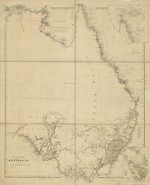
Map State Eastern Portion of Australia, East 1842/1
Australia from surveys made by order of the British Government
Eastern portion of Australia by John Arrowsmith.
London, Pubd. 1st May 1842, by John Arrowsmith, 10 Soho Sq.
EAST SHEET Extent E 130° to E 154°
OVERLAP
The sheets are designed to be joined along E 134°.The overlap of east and west sheets occurs from longitude E 130°- E 137°. Information in the area E 130° to E 134° is not updated on the east sheet indicating that the cartographer had designed the map in two sheets to be joined.
INSETS:
Torres Strait (upper right), Van Diemens Land (lower right)
Description
Shows
IMPRINT:
The date in the imprint has been changed to 1st May 1842
COLONIES:
NEW SOUTH WALES, SOUTH AUSTRALIA
REGIONS:
ARNHEM LAND, AUSTRALIA FELIX, BONNY LAND, STURT LAND, EYRE LAND, NEW ENGLAND, GIPPSLAND
TABLE: COUNTIES:
The nineteen counties in New South Wales are delineated and numbered on the map and listed in a marginal table.
BOUNDARIES:
South Australia extends from 26°S to the south coast and from 132°E to 141°E.
EXPLORERS' ROUTES:
John Edward Eyre in 1839 and 1840, Paul Edmond Strzelecki in 1840
NOTES ON COASTS:
See East sheet, 1838/1 imprint
REFERENCE:
Not in Tooley
NOTES
Northern Territory
In the 1838/2 state of the map Victoria appeared on the Coburg Peninsula. Coburg Peninsula changed to Coburg Pa (132°E)
New South Wales
The 1838/1 state of the map shows the principal river systems of the Murray, Murrumbidgee, Lachlan and the Darling, Bogan, Macquarie, Namoi, Gwydir, Dumaresq and Condamine. There are notes on Mitchell's furthest north and south on the Darling 1832, Sturt and Hume's farthest north on the Darling, March 1829, and Oxley's furthest west on the Lachlan 1817. Sturt's Depot is shown on the Murrumbidgee from whence he descended the Murrumbidgee and Murray Rivers to the sea in 36 days and returned in 40 days. Dixon's furthest west 1833 (just west of the Bogan R.) and the spot where Richard Cunningham was killed (just west of the Bogan R.) also marked.
In the 1841/1 state of the map the NEW ENGLAND region appears. Rivers flowing to the coast in this region are the Richmond R. (previous dotted line of river removed), the Evans R. the Clarence R. system, the Numbucka R. and McLeay R. The R. Severn flows to the west of the dividing range. Ben Lomond and Mt. Mitchell appear to the east of the dividing range.
Victoria
T. L. Mitchell's expeditions from Sydney to western Victoria (Glenelg R.) appear in the 1838/1 state of the map. AUSTRALIA FELIX named by him.
In the 1840/2 state the middle and upper reaches of the River Murray in the Port Phillip District are named RIVER HUME, the name by which this river was first known. Four tributaries, the Goulburn, the Delangan, the Ovens or Burwang and the R. King are shown. The River Bayungun and the Violet River have been removed
In the 1841/1 state of the map the name HUME RIVER has been removed from the Murray River which again is shown as a dashed line and the rivers Bayungun and Violet have been reinstated.
In GIPPSLAND the results of Paul Edmond Strzelecki's exploration [1840] of the Australian Alps is mapped. River systems flowing from the Australian Alps to the coast are Thomson, Riley, McArthur, Perry, Dunlop, Barney, Maconochie and Latrobe. Lake King appears. The Ovens or Burwang and the Mitta Mitta are shown flowing north. To the east of the Thomson River the map remains blank apart from Mt. Koschusko [Kosciusko] and Mt. Garrangura.
In Westernport, French Island is named, and nearby Jameson and Berry. Dodd and McCrae appear on the Mornington Peninsula.
On the west coast of Victoria new coastal names are Port Fairey, R. Barwon and Geelong. The R. Hopkins extended to the coast. L. Colac, Mt. Gellibrand and Mt. Eccles appear and a number of places with aboriginal names, i.e. R. Garanbalatt, R. Parrunyallac.
South Australia
In the 1840/1(1838/4) state of the map the most notable change is the extensive updating of information in South Australia following the explorations of Edward John Eyre in 1839 and 1840. Three regions have been distinguished; BONNY LAND is the region adjacent to the current Victorian border (E 141°) STURT LAND occupies the Fleurieu Peninsula and north to the Gouger Range, EYRE LAND occupies the currently named Eyre Peninsula.
North of Mt. Arden at the head of Spencer Gulf the Flinders Range appears trending NE/SW. Mt. Eyre is marked to the immediate west of this range. Mt. Arden is shown at the southern end. Lake Torrens appears to the west with a note above it Extensive pl. of sandy soil destitute of vegetation with sandy ridges. At the southern end of the Flinders Range a Depot is marked on a hatched track labelled Overseers tract to the E. This track extends to the west to the coast at Streaky Bay where another Depot is shown and then continues along the coast to Pt. Bell.
North-east of Gulf of St. Vincent the Gouger Ra., Mt. Pullen, Mt. Bryan, Slate Hill and Hawdon Plains appear while south of these the Rocky and Bernard ranges and further south again the Barossa Ra.
In the Fleurieu Peninsula the rivers Broughton, Hill, Light, Gawler, Torrens and Finnis are shown.
Coastal names appearing for the first time on the Gulf of St Vincent are Port Gawler, Hurtle Vale, Onkaparinga B. The Field R. has been removed.
On the Eyre Peninsula topographical features and notes on the nature of the land and vegetation also appear such as low and scrubby swamp, spring, lagoon, very dense scrub and land rises with intervals of open plain among the scrub. In the north of the peninsula Mt. Start and the Gawler Ra trending north-west / south-east and then east with numerous parallel ranges. A track from Pt. Lincoln in the south-east of the Eyre Peninsula follows the coastline north-west. New names along this coast are Mt. Dutton, Mt. Hope, Wedge Hill, Mt. Cooper and Mt. Hall.
On Encounter Bay Victor Harbour is marked.
In the 1841/1 state of the map the results of Edward John Eyre's expeditions [1839-1840] include a postulated double horseshoe shaped salt water Lake Torrens (dry) as the most notable additional feature. New place names occur north of the Flinders Range, i.e. Termination Hill, Mt. Scott, Mt. Deception, Mt. Serle, Mt. Hopeless. Also notes such as Water very salt, Barren Plains covd. By Salsolae, Brine springs, Eyre's furthest n. w. 1840 and Eyre's furthest n. e. 1840 are shown.
In the 1841/2 state of the map Arrowsmith's modus operandi is demonstrated. He firstly inserts hydrology and then topography in a later issue of the map. In this second state topography has been inserted within the horseshoe shaped Lake Torrens with 'hairy caterpillar' type hachuring and in New England and Gippsland. Compare with East sheet, 1841/1 state.
Changes AND ADDITIONS
Map unchanged except for imprint.
IMPRINT:
The date in the imprint date changed to 1st May 1842.
Otherwise this state remains unchanged from East sheet, 1841/2 state.
Key Dates
- 1606 - 1840
- Situation date
- May 1842
- Map Publication Date
Related entries
Timeline
Eastern Portion of Australia, East 1838/1
Eastern Portion of Australia, East 1838/2
Eastern Portion of Australia, East 1838/3
Eastern Portion of Australia, East 1840/1 (1838/4)
Eastern Portion of Australia, East 1840/2 (1838/5)
Eastern Portion of Australia, East 1841/1
Eastern Portion of Australia, East 1841/2
Eastern Portion of Australia, East 1842/1
Eastern Portion of Australia, East 1842/2
Eastern Portion of Australia, East 1846/1
Eastern Portion of Australia, East 1847/1
Eastern Portion of Australia, East 1847/2
Eastern Portion of Australia, East 1848/1
Eastern Portion of Australia, East 1849/1 (1848/2)
Eastern Portion of Australia, East 1850/1
Eastern Portion of Australia, East 1853/1
Eastern Portion of Australia, East 1856/1
Eastern Portion of Australia, East 1858/1
Eastern Portion of Australia, East 1860/1 (1858/2)
Eastern Portion of Australia, East 1861/1
Eastern Portion of Australia, East 1863/1 (1862/1)
[Australia, East], 1884/1
Australia, East 1887
Institutional and Other Holdings
British Library Map Library
- Australia, from surveys made by order of the British Government ... By John Arrowsmith. [Scale,] English miles ... 200[= 50 mm], 1841, Maps 90050.(62.); British Library Map Library. Details
Cambridge University Library
- Eastern Portion of Australia, Maps.573.84.2; Cambridge University Library. Details
Royal Geographical Society
- Australia from surveys made by order of the British Government combined with those of D'Entrecasteaux, Baudin, Freycinet, &c. &c, 1842, mr Australia G.39; Royal Geographical Society. Details
State Library of Victoria, Maps Collection
- Eastern portion of Australia [cartographic material]/ by John Arrowsmith., 1842, MAPS 804 A 1842 ARROWSMITH; State Library of Victoria, Maps Collection. Details
Published resources
Books
- Tooley, Ronald Vere, The mapping of Australia and Antarctica, Holland Press, London, 1985, 649 pp. Details
Images
- Title
- Eastern portion of Australia
- Type
- Map
- Repository
- State Library of Victoria, Maps Collection
Dorothy F. Prescott
Created: 15 July 2011, Last modified: 3 July 2012