
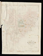
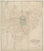
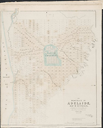
Map State The District of Adelaide, South Australia, 1841/2
The district of Adelaide, South Australia: as divided into country sections from the trigonometrical surveys of Colonel Light, late Survr. Genl / John Arrowsmith 10 Soho Square 1839. London, Published Feby 18th 1840, by John Arrowsmith, 10 Soho Square.
Ordered by the House of Commons to be Printed June 10th, 1841. -- Scale [ca. 1:43 500]. Scale 1" = 55 chains. -- 1 map : col. ; 62.0 x 51.0 cm. Marginal title: Appendix to Report from the Select Committee on South Australia. No. 2.
Description
Shows
TITLE:
Lower right hand corner of map. The statement of responsibility reads: John Arrowsmith 10 Soho Square 1839.
PLATE NO:
None. It does not at any stage appear to have had a plate number printed on the face
IMPRINT:
The imprint reads London, Published Feby 18th 1840, by John Arrowsmith, 10 Soho Square and under this a second imprint, Ordered by the House of Commons to be Printed June 10th, 1841.
PRINTER:
In lower right-hand corner outside neat-line: James & Luke J. Hansard Printers.
MARGINAL TITLE:
Top right hand corner outside neat-line: Appendix to Report from Select Committee on South Australia No. 2.
PAPER NO.:
A House of Commons Paper No. (394) is printed in lower left margin
KEY:
Outside top left hand corner of neat-line is a 4 line key to landholders showing, A= South Australian Company, B= Jno. A. Smith, PR= Public Reserve, GR = Government Reserve.
LANDHOLDERS
The map identifies purchasers of land sections
REFERENCE
F 3219 Great Britain and Ireland. Parliament -- South Australia -- Second Report of Select Committee.
Second Report from the Select Committee on South Australia; together with Minutes of Evidence, appendix , and index. Ordered, by the House of Commons to be Printed, 10 June 1841.
Tooley 1447 but with addition of Parliamentary paper number 394.
NOTES
The map appears first as a normal Arrowsmith publication with the imprint shown as from his premises in 35 Essex Street. The map is a cadastral plan of the area immediately surrounding Adelaide and covers an area from Port Adelaide in the north down to present day Brighton in the south (5 km beyond Glenelg which is shown on this map).
In Adelaide the map shows the roads, canals, schools, store, barracks, cemetery and hospital. Also shows surveyed sections numbered and available for sale in two sizes, small lots of 80 acres and large lots of 134 acres. Those sold are coloured and carry the landholders' names. The numbering system of surveyed lots is by two parallel sequences of numbers not immediately apparent unless the accompanying list of purchasers is available. Trigonometrical survey stations are marked.
There is an indication to prospective buyers of areas where the streams dry up in summer. The relief is shown by hachures and hill shading and vegetation is indicated.
Tributaries of the River Torrens are shown.
The 1839/2 state is the first indication that the map has been published officially.
In this 1839/3 issue there is now a clear statement of a Parliamentary printing, whereas in 1839/2 this is implied by the printer statement of the Hansards and the use of an official title statement of a Parliamentary Committee Report.
In the 1839/4 issue a Hansard printer statement appears.
In the 1839/5 Lords issue the printer statement is lacking.
The 1840/1 issue is a new Arrowsmith state of the map.
The 1841/1 state of the map is utilised by Parliament to illustrate the Report of the Select Committee on South Australia
The issue described here has a Parliamentary paper number (394) added in lower left margin.
Changes AND ADDITIONS
PAPER NO:
This issue has a paper number added in lower left margin: (394)
Other locations
Great Britain. Parliament. House of Commons. Select Committee on South Australia.
Second Report from the Select Committee on South Australia : together with Minutes of Evidence, appendix and index. [London] : Ordered by the House of Commons to be Printed, 1841. VU SpC/AX f 994.2 E58 Map f. p. 354.
Spine title of volume: Parliamentary Papers. South Australia. Select Committee Reports 1 and 2. 1841
Great Britain. Parliament. House of Commons. Select Committee on South Australia.
Second report from the Select Committee on South Australia : together with Minutes of Evidence, appendix and index. [London] Ordered by the House of Commons to be Printed, 1841. VSL RARELTF 325.94 SO8
Great Britain. Parliament. House of Commons. Reports from Committees. 1841 session 1.
Second report from the Select Committee on South Australia : together with Minutes of Evidence, appendix and index. (394) [London] : Ordered by the House of Commons to be printed, 1841. Map f. p. 9, v. IV, 1841. VSL YA 328.41072
Key Dates
- 1838 - 1840
- Situation date
- 10 June 1841
- Map Publication Date
Related entries
Timeline
The District of Adelaide, South Australia, 1839/1
The District of Adelaide, South Australia, 1839/2
The District of Adelaide, South Australia, 1839/3
The District of Adelaide, South Australia, 1839/4
The District of Adelaide, South Australia, 1839/5
The District of Adelaide, South Australia, 1840/1
The District of Adelaide, South Australia, 1841/1
The District of Adelaide, South Australia, 1841/2
The District of Adelaide, South Australia, 1841/3
Institutional and Other Holdings
National Library of Australia Map Collection
- The District of Adelaide, South Australia [cartographic material] : as divided into country sections, from the trigonometrical surveys of Colonel Light late Survr. Genl. / John Arrowsmith, 10 Soho Square, 1839, MAP T 1447; National Library of Australia Map Collection. Details
Royal Geographical Society of South Australia Inc.
- Second report from the Select Committee on South Australia : together with the minutes of evidence, appendix, and index Report from the Select Committee on South Australia, 1941, rgsp 994.2302 G786 c; Royal Geographical Society of South Australia Inc. Details
State Library of South Australia
- The District of Adelaide, South Australia [cartographic material] : as divided into country sections, from the trigonometrical surveys of Colonel Light late Survr. Genl. / John Arrowsmith, 10 Soho Square, 1839, 1841, zmp 00344143; State Library of South Australia. Details
- The District of Adelaide, South Australia, as divided into Country Sections [map]/ from the Trigonometrical Surveys of Colonel Light, late Surv.r Gen.l, C 794; State Library of South Australia. Details
The University of Melbourne Library, Special Collections
- Reports from the Select Committee on South Australia : together with the minutes of evidence, appendix, and index., 1841, UniM Bail SpC/AX f 994.2 E58; The University of Melbourne Library, Special Collections. Details
- Second report from the Select Committee on South Australia : together with the minutes of evidence, appendix, and index., UniM Bail SpC/AX f 994.2 E58; The University of Melbourne Library, Special Collections. Details
Published resources
Books
Images
- Title
- The District of Adelaide, South Australia, 1841/2
- Type
- Map
- Repository
- The University of Melbourne Library, Special Collections
- Title
- The District of Adelaide, South Australia, 1841/2
- Type
- Map
- Repository
- State Library of South Australia
- Title
- The District of Adelaide, South Australia, 1841/2
- Type
- Map
- Repository
- National Library of Australia Map Collection
Dorothy F. Prescott
Created: 10 September 2010, Last modified: 3 July 2012