
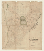
Map State The District of Adelaide, South Australia, 1839/4
The district of Adelaide, South Australia: as divided into country sections from the trigonometrical surveys of Colonel Light, late Survr. Genl / John Arrowsmith 35 Essex Street 1839. London, Published Feby 18th 1839, by John Arrowsmith, 35 Essex Street, Strand.
Ordered by the House of Commons to be Printed, 13th May 1839. James, Luke G. and Luke J. Handsard Printers. -- Scale [ca. 1:43 500]. Scale 1" = 55 chains. -- 1 map : col. ; 62.0 x 51.0 cm. -- Marginal title top right: Third Annual Report of the South Australia Colonization Commissioners.
Description
Shows
TITLE:
Lower right hand corner of map.
PLATE NO:
None. It does not at any stage appear to have had a plate number printed on the face
IMPRINT:
There are now two imprints centre lower margin which read:
London, Published Feby 18th 1839, by John Arrowsmith, 35 Essex Street and under this Ordered by the House of Commons to be Printed, 13th May 1839.
PRINTER:
In lower right hand corner outside neat-line: James, Luke G. & Luke J. Hansard Printers.
MARGINAL TITLE:
The marginal title appears in the top right-hand corner outside the neat-line: Third Annual Report of the South Australia Colonization Commissioners
LANDHOLDERS
The map identifies purchasers of land sections
REFERENCES
F 2735 Colonization Commissioners for South Australia.
Third Annual Report of the Colonization Commissioners for South Australia to Her Majesty's Principal Secretary of State for the Colonies. 1838. Presented pursuant to Act 4 & Act 5 Will. Iv. C. 95. Ordered by the House of Commons to be Printed, 13 May 1839. (255)
Tooley 112
NOTES
The map appears first as a normal Arrowsmith publication with the imprint shown as from his premises in 35 Essex Street.. The map is a cadastral plan of the area immediately surrounding Adelaide and covers an area from Port Adelaide in the north down to present day Brighton in the south (5 km beyond Glenelg which is shown on this map).
In Adelaide the map shows the roads, canals, schools, store, barracks, cemetery and hospital. Also shows surveyed sections numbered and available for sale in two sizes, small lots of 80 acres and large lots of 134 acres. Those sold are coloured and carry the landholders' names. The numbering system of surveyed lots is by two parallel sequences of numbers not immediately apparent unless the accompanying list of purchasers is available. Trigonometrical survey stations are marked.
There is an indication to prospective buyers of areas where the streams dry up in summer. The relief is shown by hachures and hill shading and vegetation is indicated.
Tributaries of the River Torrens are shown.
The 1839/2 state is the first indication that the map has been published officially.
In the 1839/3 issue there is now a clear statement of a Parliamentary printing, whereas in 1839/2 this is implied by the printer statement of the Hansards and the use of an official title statement of a Parliamentary Committee Report.
In the 1839/4 issue a Hansard printer statement appears.
Changes AND ADDITIONS
As state 1839/3 but with the addition of a printer statement for the Hansards.
PRINTER:
In lower right hand corner outside neat-line: James, Luke G. & Luke J. Hansard Printers.
NOTES
Occurs in:
South Australian Colonization Commission.
Annual report of the Colonization Commission for South Australia to His Majesty's Principal Secretary of State for the Colonies. London : House of Commons, 1836-1840. Parliamentary Paper no. 255 of 1839. VU SpC/AX f 994.2 E58 v. 2nd-3rd Map f. p. 60.
Other Locations
Also occurs in:
Third annual report of the Colonization Commissioners for South Australia to Her Majesty's Principal Secretary of State for the Colonies. Ordered by the House of Commons to be Printed 13 May 1839. (255). Map f. p. 60. This map occurs in a volume with spine title Transportation Sundry Reports, 1830-1862, VU SpC/AX f 365 E 58
Third annual report of the Colonization Commissioners for South Australia to Her Majesty's Principal Secretary of State for the Colonies. Ordered by the House of Commons to be printed 13 May 1839. (255). Appendix no 19 A. House of Commons Sessional Papers, v. XVII, 1839. Map f. p. 60. Map missing seen in 1992. VU SpC/BX f 328.41 GREA
Key Dates
- 1837 - 1839
- Situation date
- 13 May 1839
- Map Publication Date
Related entries
Timeline
The District of Adelaide, South Australia, 1839/1
The District of Adelaide, South Australia, 1839/2
The District of Adelaide, South Australia, 1839/3
The District of Adelaide, South Australia, 1839/4
The District of Adelaide, South Australia, 1839/5
The District of Adelaide, South Australia, 1840/1
The District of Adelaide, South Australia, 1841/1
The District of Adelaide, South Australia, 1841/2
The District of Adelaide, South Australia, 1841/3
Institutional and Other Holdings
State Library of South Australia
- The District of Adelaide, South Australia [cartographic material] : as divided into county sections, from the trigonometrical surveys of Colonel Light late Survr. Genl. / John Arrowsmith, 35 Essex Street, 1839, C 72 A; State Library of South Australia. Details
The University of Melbourne Library, Special Collections
- Annual report of the Colonization Commissioners of South Australia to His Majesty's Principal Secretary of State for the Colonies., UniM Bail SpC/AX f 365 E58; The University of Melbourne Library, Special Collections. Details
- Annual report of the Colonization Commissioners of South Australia to His Majesty's Principal Secretary of State for the Colonies., UniM Bail SpC/AX f 994.2 E58 1st-3rd; The University of Melbourne Library, Special Collections. Details
Published resources
Books
Images
- Title
- The District of Adelaide, South Australia, 1839/4
- Type
- Map
- Repository
- State Library of South Australia
- Title
- The District of Adelaide, South Australia, 1839/4
- Type
- Map
- Repository
- The University of Melbourne Library, Special Collections
Dorothy F. Prescott
Created: 10 September 2010, Last modified: 25 March 2013