
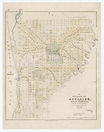
Map State The District of Adelaide, South Australia, 1840/1
The district of Adelaide, South Australia: as divided into country sections from the trigonometrical surveys of Colonel Light, late Survr. Genl / John Arrowsmith 10 Soho Square 1839. London, Published Feby 18th 1840, by John Arrowsmith, 10 Soho Square.
-- Scale [ca. 1:43 500]. Scale 1" = 55 chains. -- 1 map : col. ; 62.0 x 51.0 cm.
Description
Shows:
TITLE
Lower right hand corner of map. The statement of responsibility reads: John Arrowsmith 10 Soho Square 1839
PLATE NO:
None. It does not at any stage appear to have had a plate number printed on the face
IMPRINT:
The imprint now reads: London, Published Feby 18th 1840, by John Arrowsmith, 10 Soho Square.
KEY:
Outside top left hand corner of neat-line is a 4 line key to landholders showing, A= South Australian Company, B= Jno. A. Smith, PR= Public Reserve, GR = Government Reserve.
LANDHOLDERS
The map identifies purchasers of land sections
REFERENCE
F 2964A [Dawson, Robert Kearsley]
Report on surveying considered with reference to New Zealand, and applicable to the Colonies generally. London: Printed by W. Clowes and Sons, Stamford Street, For Her Majesty's Stationery Office. 1840.
NOTES
The map appears first as a normal Arrowsmith publication with the imprint shown as from his premises in 35 Essex Street. The map is a cadastral plan of the area immediately surrounding Adelaide and covers an area from Port Adelaide in the north down to present day Brighton in the south (5 km beyond Glenelg which is shown on this map).
In Adelaide the map shows the roads, canals, schools, store, barracks, cemetery and hospital. Also shows surveyed sections numbered and available for sale in two sizes, small lots of 80 acres and large lots of 134 acres. Those sold are coloured and carry the landholders' names. The numbering system of surveyed lots is by two parallel sequences of numbers not immediately apparent unless the accompanying list of purchasers is available. Trigonometrical survey stations are marked.
There is an indication to prospective buyers of areas where the streams dry up in summer. The relief is shown by hachures and hill shading and vegetation is indicated.
Tributaries of the River Torrens are shown. A key has been added to the map referring to landholders.
The 1839/2 state is the first indication that the map has been published officially.
In this 1839/3 issue there is now a clear statement of a Parliamentary printing, whereas in 1839/2 this is implied by the printer statement of the Hansards and the use of an official title statement of a Parliamentary Committee Report.
In the 1839/4 issue a Hansard printer statement appears.
In the 1839/5 Lords issue the printer statement is lacking.
This issue is a new state of the map.
Changes AND ADDITIONS
TITLE
The statement of responsibility is amended to show a change of address
IMPRINT:
The imprint now reads: London, Published Feby 18th 1840, by John Arrowsmith, 10 Soho Square.
PRINTER:
The printer statement has been removed
MARGINAL TITLE:
The marginal title has been removed
KEY:
A 4 line key to landholders key appears outside top left hand corner of neat-line showing, A= South Australian Company, B= Jno. A. Smith, PR= Public Reserve, GR = Government Reserve.
NOTES
This is a revised state which shows further sales of land mostly north and west of Adelaide and along the coast.
The map also appears at end of the text in [Dawson, Robert Kearsley] Report on surveying. See reference above. Tas. Arch. (CSO 8/19/526)
Key Dates
- 1837 - 1840
- Situation date
- 18 February 1840
- Map Publication Date
Related entries
Timeline
The District of Adelaide, South Australia, 1839/1
The District of Adelaide, South Australia, 1839/2
The District of Adelaide, South Australia, 1839/3
The District of Adelaide, South Australia, 1839/4
The District of Adelaide, South Australia, 1839/5
The District of Adelaide, South Australia, 1840/1
The District of Adelaide, South Australia, 1841/1
The District of Adelaide, South Australia, 1841/2
The District of Adelaide, South Australia, 1841/3
Institutional and Other Holdings
Dixson Map Collection, State Library of New South Wales
- The District of Adelaide, South Australia [cartographic material] : as divided into country sections, from the trigonometrical surveys of Colonel Light late Survr. Genl. / John Arrowsmith, 10 Soho Square, 1839., Cb 84/32; Dixson Map Collection, State Library of New South Wales. Details
Library of Congress, Geography and Map Division
- The London Atlas of Universal Geography, exhibiting the physical & political divisions of the various countries of the world, constructed from original materials, 1840, G1019 .A8 1840 Vault fol. Copy 1; Library of Congress, Geography and Map Division. Details
State Library of South Australia
- The District of Adelaide, South Australia [cartographic material] : as divided into country sections, from the trigonometrical surveys of Colonel Light late Survr. Genl. / John Arrowsmith, 10 Soho Square, 1839, 1840, rbr 325037; State Library of South Australia. Details
The University of Melbourne Library, Special Collections
- Reports from the Select Committee on South Australia : together with the minutes of evidence, appendix, and index., 1841, UniM Bail SpC/AX f 994.2 E58; The University of Melbourne Library, Special Collections. Details
Published resources
Books
Images
- Title
- The District of Adelaide, South Australia, 1840/1
- Type
- Map
- Repository
- State Library of South Australia
- Title
- The District of Adelaide, South Australia, 1840/1
- Type
- Map
- Repository
- Dixson Map Collection, State Library of New South Wales
Dorothy F. Prescott
Created: 10 September 2010, Last modified: 3 July 2012