
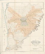
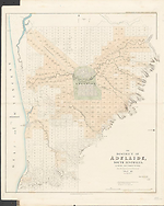
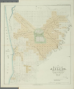
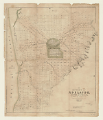
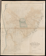
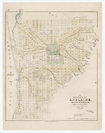
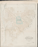
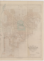
Map Summary The District of Adelaide, South Australia
Adelaide, the capital of South Australia, was founded in December 1836 as a planned city, in the new colony of South Australia. The history of the colony and the efforts to establish it go back to 1831 when a group of gentlemen in Britain attempted to obtain a royal charter for the South Australian Land Company which they envisaged would be aimed at establishing a Province for free settlers as opposed to the existing penal colonies already established in the continent. These efforts came to nought. The next attempt to raise interest by the British government in establishing a free colony was made by the South Australian Association and this succeeded in the passing of the South Australia Act of 1834.
The task of planning the city of Adelaide was given to Colonel William Light by the Colonization Commissioners for South Australia, a committee established by the British Parliament in 1835 for overseeing the establishment of the colony. He also chose the location despite dissent by many including initially Governor Hindmarsh.
Adelaide is situated on an alluvial plain between the southern flanks of the Mount Lofty Ranges and the low sandy coast of the Gulf of Saint Vincent. The River Torrens provided a water source and access to the sea was by of the Port River and Patawalonga Rivers, the two deltaic mouths of the Torrens. The plan was a grid pattern surrounded by parklands which has stood Adelaide well over the succeeding years.
The inclusion of the map in John Arrowsmith's Atlas is not really surprising considering the fact that his atlas had only just appeared in 1834 and was the best source of information for British people considering emigration to other British colonies. This plan could have been commissioned from Arrowsmith by a prospective immigrant to whom the chance of being a free settler in the new colony proved irresistible. On the other hand it may have originated at the instigation of the Colonization Commissioners who were much disturbed by the slowness of the survey being executed for the city. The history of the plan and of those involved in the execution of the survey is fascinating. Briefly, the delay in the surveying of lots for newly arrived settlers, which began in January 1837, caused much disquiet to the Colonization Commissioners, the South Australian Company (founded October 1835) and newly arrived settlers. As a result the Surveyor General, Colonel William Light, was informed by the Colonization Commissioners on the method he should adopt for the survey to be implemented more quickly. Colonel Light did not agree with the orders given to him.
There is a hint of skulduggery in the proposed suspension of Colonel Light in favour of his deputy George Kingston, who had been sent to England by Light earlier in the year to request further support for the Survey Department. On the 22nd June1838 Light refused to implement the Commissioners directions for a running survey. On 2nd July1838 eleven staff of the Survey department resigned, one of the reasons proffered being "Mr. Kingston's unbecoming and ungentlemanly behaviour."(Colonization Commissioners 1839). Colonel Light then resigned and formed his own survey business with B.T. Finniss. Henry Nixon one of the remaining surveyors resigned from George Kingston's survey team complaining of over work and joined Light and Finniss (RGSSA Promotion Leaflet). The map of Adelaide 'Plan of the preliminary country country sections in the district of Adelaide, South Australia: from the surveys of Wm. Light Esqr. Suryr. Genl. and assistant surveyors / drawn by Henry Nixon., was created from information gathered by Colonel Light's surveyors prior to the above events. The plan of Adelaide in Arrowsmith's Atlas is copied from the plan of the city drawn by Henry Nixon in 1837-8 under the direction of Colonel William Light. See also Nixon.
Colonization Commissioners for South Australia Third Annual Report. 1839 (255) p. 35.
History of the South Australian Company (BRG 42) SA Memory, State Library of South Australia
Royal Geographical Society of South Australia. [Flyer] [2009] Henry Nixon's Map 1838.
Description
The district of Adelaide, South Australia: as divided into country sections from the trigonometrical surveys of Colonel Light / John Arrowsmith 35 Essex Street 1839. London, Published Feby. 18th. 1839, by John Arrowsmith, 35 Essex Street, Strand. --Scale [ca. 1:43 500]. Scale 1" = 55 chains. --1 map : col. ; 62.0 x 51.0 cm.
Related entries
Published resources
Resource Sections
- 'History of the South Australian Company (BRG 42)', in SA Memory, State Library of South Australia, http://www.samemory.sa.gov.au/site/page.cfm?u=1483. Details
Images
- Title
- The District of Adelaide, South Australia, 1839/1
- Type
- Map
- Repository
- National Library of Australia Map Collection
- Title
- The District of Adelaide, South Australia, 1839/2
- Type
- Map
- Repository
- National Library of Australia Map Collection
- Title
- The District of Adelaide, South Australia, 1839/3
- Type
- Map
- Repository
- National Library of Australia Map Collection
- Title
- The District of Adelaide, South Australia, 1839/4
- Type
- Map
- Repository
- State Library of South Australia
- Title
- The District of Adelaide, South Australia, 1839/5
- Type
- Map
- Repository
- The University of Melbourne Library, Special Collections
- Title
- The District of Adelaide, South Australia, 1840/1
- Type
- Map
- Repository
- State Library of South Australia
- Title
- The District of Adelaide, South Australia, 1841/2
- Type
- Map
- Repository
- National Library of Australia Map Collection
- Title
- The District of Adelaide, South Australia, 1841/3
- Type
- Map
- Repository
- The University of Melbourne Library, Special Collections
Dorothy F. Prescott
Created: 10 September 2010, Last modified: 29 August 2013