
Map State Maritime Portion of South Australia, 1839/1
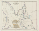
The maritime portion of South Australia: from the surveys of Captn. Flinders & of Col. Light, Survr. Genl. by John Arrowsmith. -- Scale [ca. 1:1 350 000 at 36° S] (S 32°-S 38° 15'/ E 132°-E 141°). -- London, Published February 5th.1839, by John Arrowsmith, 35 Essex Street, Strand. -- 1 map : col. ; 51.0 x 63.5 cm. - Insets: Lower right: Sketch of Nepean Bay and Kingscote Harbour / by William Chesser. - Centre bottom: The city of Adelaide with acre allotments numbered, surveyed by Col. Light. - At left: [Gulf of St. Vincent]
Description
PLATE NO:
There is no plate number printed on these maps. Those maps which are recorded as having plate numbers shown beside them may have had this number added in ms. to either the recto or the verso of the sheet in the atlas in which they have been recorded.
IMPRINT:
The date is changed to February 5th 1839.
INSET: [Gulf of St. Vincent]
In the 1839/1 state of the map the inset Gulf of St. Vincent has number of new streams, namely, Ormsby R., Anstey R., R. Todd, R. Hallet and one un-named stream as north flowing tributaries of the Torrens River.
Slightly below the Torrens River part of a stream appears named Brown-hill R. and below this a further stream named R. Sturt which debouches at Glenelg.
NOTES
The 1838/2 state of the map shows South Australia from 32° S southwards and includes both the western and eastern boundaries of the Colony. As the title suggests the information is mainly coastal in nature. Three inset maps fill the offshore area. They are Sketch of Nepean Bay and Kingscote Harbour by Wm. Chesser, The city of Adelaide with acre allotments numbered, surveyed by Col. Light, and [Gulf of St. Vincent].
The mouth of the Murray River shows Hindmarsh Island and in Lake Alexandrina soundings are shown at the narrow neck on which Pt. Sturt and Pt. McLeay appear. To the west of Lake Alexandrina Hindmarsh R. is now named. Also in this area are Small Hr. and Seal R. and Wright I. Mt. Wakefield is shown on the south coast of the Fleurieu Peninsula.
INSET: [Gulf of St. Vincent]
In the 1838/2 state of the map the inset Gulf of St Vincent showed new information added on the south coast. Wakefield Ms. named on the south coast of the Fleurieu Peninsula. Wright I. replaced Sugar Loaf. Rosetta Hr. was moved further south-west and its previous location is now called Victor Hr. Granite I., Rocky Pt. and Capel Sd. appeared. Kangaroo R., Hindmarsh R. and Currency Cr. are also shown.
In the 1839/1 state of the [Gulf of St. Vincent] additional streams are shown.
PRELIMINARY ISSUE:
A prototype was issued in May 1838 which appears to be a preliminary proof lacking the main title and the title to the inset of Adelaide which are present in further states.
See A New Map of South Australia.
CHANGES AND ADDITIONS
The only changes to this 1839/1 state are the imprint date and additions to the inset [Gulf of St. Vincent]
IMPRINT:
The date is changed to February 5th 1839.
Key Dates
- 1802 - 1839
- Situation date
- 5 Feb 1839
- Map Publication Date
Related entries
Timeline
A New Map of South Australia (11 May 1838)
Maritime Portion of South Australia, 1838/2
Maritime Portion of South Australia, 1839/1
Maritime Portion of South Australia, 1839/2
Maritime Portion of South Australia, 1839/3
Maritime Portion of South Australia, 1840/1
Maritime Portion of South Australia, 1841/1
Maritime Portion of South Australia, 1841/2
Institutional and Other Holdings
National Library of Australia Map Collection
- The Maritime Portion of South Australia [cartographic material] : from the surveys of Captn. Flinders & of Col. Light, Survr. Genl. / by John Arrowsmith, MAP RM 4960; National Library of Australia Map Collection. Details
Published resources
Books
- Tooley, Ronald Vere, The mapping of Australia and Antarctica, Holland Press, London, 1985, 649 pp. Details
Images
- Title
- Maritime Portion of South Australia, 1839/1
- Type
- Map
- Repository
- National Library of Australia Map Collection
Dorothy F. Prescott
Created: 20 September 2019, Last modified: 29 October 2019