
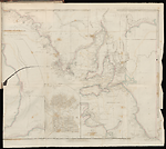
Map State Maritime Portion of South Australia, 1841/1
The maritime portion of South Australia, from Captn Flinders & from more recent surveys made by the Survr Genl of the Colonies by John Arrowsmith. -- Scale [ca. 1:1 350 000 at 36° S] (S 32°-S 38° 15'/ E 132°-E 141°). -- London, Published Feby. 5th 1840 … 10 Soho Square. Ordered by the House of Commons to be printed June 10th 1841. James & Luke J. Hansard, Printers. (394). -- 1 map : col. ; 51.0 x 63.5 cm.
Marginal title: APPENDIX TO REPORT FROM THE SELECT COMMITTEE ON SOUTH AUSTRALIA. A.
INSETS:
Top right: Sketch of Encounter Bay by Colonel Light and B. T. Finniss Esqr. 1838. -- Lower right: Sketch of Nepean Bay and Kingscote Harbour. -- Centre bottom: The city of Adelaide with the acre allotments numbered and surveyed by Col. Light. -- At left: [Gulf of St. Vincent].
Description
PLATE NO:
There is no plate number printed on these maps. Those which are recorded as having plate numbers shown beside them may have had this number added in ms. to either the recto or the verso of the sheet in the atlas in which they have been recorded
IMPRINT:
Now reads: Published Feby. 5th 1840 ... 10 Soho Square.
IMPRINT:
The additional House of Commons imprint, Ordered by the House of Commons to be printed June 10th 1841 appears.
PRINTER:
In lower right margin: James and Luke J. Hansard, Printers.
PAPER NO:
In lower left margin (394)
MARGINAL TITLE:
An additional marginal title is found in the top right hand margin above the marginal note: APPENDIX TO REPORT FROM THE SELECT COMMITTEE ON SOUTH AUSTRALIA. A.
MARGINAL NOTE:
Upper right margin: Torrens L. and Mr Eyre's route to the N of Mt Arden are placed too far S by about 11 miles.
REGIONS:
STURT LAND, BONNY LAND, EYRE LAND
REFERENCE:
F 3219 Second Report from the Select Committee on South Australia : together with Minutes of Evidence, appendix and index. Ordered, by, The House of Commons, to be printed, 10th June 1841. [394]
NOTES:
The 1838/2 state of the map shows South Australia from 32° S southwards and includes both the western and eastern boundaries of the Colony. As the title suggests the information is mainly coastal in nature. The main map has three inset maps. They are, Sketch of Nepean Bay and Kingscote Harbour by Wm. Chesser, The city of Adelaide with acre allotments numbered, surveyed by Col. Light, and [Gulf of St. Vincent].
In the 1839/1 state of the map the INSET Gulf of St Vincent shows a number of new streams, namely, Ormsby R., Anstey R., R. Todd, R. Hallet and one un-named stream as north flowing tributaries of the Torrens River. Further south Brownhill R. and R. Sturt are shown.
Also in the 1839/1 state a new INSET map is inserted Sketch of Encounter Bay by Col. Light and B.T. Finniss Esqr. 1838. This plan shows Victor Harbour and Rosetta Harbour, a proposed town and allotments of land laid out for sale.
The 1839/2 state of the map has only a change of address and is otherwise unchanged.
The 1840/1 state of the map has been completely revised with a change of title which is now located at the top left of the map. Much new information appears. The Eyre Peninsula is shown as EYRE LAND with Eyre's track (unnamed) from the peninsula going westward along the coast towards Streaky Bay and on to Pt. Bell (32°S /133°'05'E) then north via the Gawler Range to Mt. Arden.
North of Spencer Gulf the Flinders Range and the tip of L. Torrens appear. New topographic features to the north-east of Yorke Peninsula include Crystal Brook, Rocky R., R. Broughton and Reedy Cr. East of these streams are parallel north/south trending ranges. There is much development north and east of Adelaide with many unnamed streams and ranges. This area has been named STURT LAND.
East of the Murray River the entire area reaching to the south coast is named BONNY LAND.
The 1841/1 state of the map shows it has been used for a Parliamentary Paper. No other changes have been made to the map apart from the imprint dates and additional marginal title and Hansard printer statement.
PRELIMINARY ISSUE:
A prototype was issued in May 1838 which appears to be a preliminary proof lacking the main title and the title to the inset of Adelaide which are present in the following states.
See A New Map of South Australia.
Changes AND ADDITIONS
MARGINAL TITLE:
An additional marginal title is found in the top right hand margin above the marginal note: APPENDIX TO REPORT FROM THE SELECT COMMITTEE ON SOUTH AUSTRALIA. A.
IMPRINT:
The additional House of Commons imprint, Ordered by the House of Commons to be printed June 10th 1841 appears.
PRINTER:
In lower right margin: James and Luke J. Hansard, Printers.
PAPER NO:
In lower left margin (394)
Key Dates
- 1802 - 1839
- Situation date
- 10 June 1841
- Map Publication Date
Related entries
Timeline
A New Map of South Australia (11 May 1838)
Maritime Portion of South Australia, 1838/2
Maritime Portion of South Australia, 1839/1
Maritime Portion of South Australia, 1839/2
Maritime Portion of South Australia, 1839/3
Maritime Portion of South Australia, 1840/1
Maritime Portion of South Australia, 1841/1
Maritime Portion of South Australia, 1841/2
Institutional and Other Holdings
National Library of Australia Map Collection
- The maritime portions of South Australia [cartographic material] : from Captn. Flinders & from more recent surveys made by The Survr. GenL. of The Colonies / by John Arrowsmith, MAP T 111; National Library of Australia Map Collection. Details
State Library of Victoria, Rare Books
- Second report from the Select Committee on South Australia : together with the minutes of evidence, appendix, and index. Great Britain. Parliament. House of Commons. Select Committee on South Australia, 325.94 SO8; State Library of Victoria, Rare Books. Details
The University of Melbourne Library, Special Collections
- Second report from the Select Committee on South Australia : together with the minutes of evidence, appendix, and index., UniM Bail SpC/AX f 994.2 E58; The University of Melbourne Library, Special Collections. Details
Published resources
Books
Images
- Title
- Maritime Portion of South Australia, 1841/1
- Type
- Map
- Repository
- The University of Melbourne Library, Special Collections
- Title
- Maritime Portion of South Australia, 1841/1
- Type
- Map
- Repository
- National Library of Australia Map Collection
Dorothy F. Prescott
Created: 9 September 2010, Last modified: 25 March 2013