
Map State A New Map of South Australia (11 May 1838)
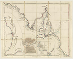
A new map of South Australia. -- London, Published May 11th 1838, by John Arrowsmith, 35 Essex Street, Strand. Sold by J. Cross, 18 Holborn, opposite Furnival's Inn, London. -- Scale [ca. 1: 1 350 000] (S 32°--S 38° 15'/E 132° -- E 141°). -- 1 map ; col., mounted on linen ; on sheet 55 x 68cm., segmented and folded to 19 x 12cm.
Insets:
Lower right: Sketch of Nepean Bay and Kingscote Harbour. -- Centre bottom: [The City of Adelaide with acre allotments numbered and surveyed by Col. Light.]. -- At left: [Gulf of St. Vincent].
TITLE:
Title taken from container.
MAP SELLER:
Map seller details from container.
Description
This map is the unfinished prototype for The Maritime Portion of South Australia, lacking title and creator statement. It was released a month before the first state of The Maritime Portion of South Australia, which appeared on June 5th 1838.
Described as follows in the catalogue note from State Library of South Australia: "Earlier version of C 934. This map is based on the surveys of Matthew Flinders and Col. William Light. It shows the coast from Fowlers Bay in the west to the Victorian border in the east and gives soundings, place names, notes on natural features and comments such as 'natives seen' near Coffin Bay and 'met Le Geographe coming from the S.E.' in Encounter Bay near the mouth of the Murray. Possibly a prototype for the Maritime Portion of South Australia this map is dated barely a month before the first issue bearing the later title." See The Maritime Portion of South Australia for further states of this map.
The coastline with comments is taken mostly from Flinders' plates IV and V of his Atlas to A Voyage to Terra Australis and rendered at a reduced scale. The nautical information includes the track of Flinders' vessel Investigator in 1802. Later information is taken from Freycinet , Grant and the surveys of Col. Light, Surveyor General of South Australia. See the Summary for details.
INSET:
The inset of Adelaide lacks a title and a linear scale.
INSET:
[Gulf of St. Vincent] Lacks a title and a linear scale.
Key Dates
- 1802 - 1838
- Situation date
- 11 May 1838
- Map Publication Date
Related entries
Timeline
A New Map of South Australia (11 May 1838)
Maritime Portion of South Australia, 1838/2
Maritime Portion of South Australia, 1839/1
Maritime Portion of South Australia, 1839/2
Maritime Portion of South Australia, 1839/3
Maritime Portion of South Australia, 1840/1
Maritime Portion of South Australia, 1841/1
Maritime Portion of South Australia, 1841/2
Institutional and Other Holdings
State Library of South Australia
Published resources
Books
- Tooley, Ronald Vere, The mapping of Australia and Antarctica, Holland Press, London, 1985, 649 pp. Details
Images
Dorothy F. Prescott
Created: 9 September 2010, Last modified: 3 July 2012