
Map State Map of the Discoveries in Australia, 1834/3
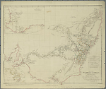
Map of the discoveries in Australia copied from the latest M.S. Surveys in the Colonial Office … by J. Arrowsmith. [Pl.] 35 Scale [ca. 1:3 000 000]. S 26° 30'-S 38° 30'/E 135°-E 154° 20'. London, Pubd. 15th.Feby. 1834 by J. Arrowsmith, 33 East Street, Red Lion Square.
1 map : col. ; 49 x 52 cm.
Insets: Top left. The Colony of Western Australia. -- Bottom left: [Australasia]
Marginal notes: Top right margin: b) Note on the Karaula River by T. L. Mitchell. -- Bottom left margin: a) Three line description of the Murray River. -- Table: Reference to the tracks of the travellers and the number of miles explored by each.
Description
Shows
TITLE:
The title includes a dedication to Viscount Goderich as follows:
By Permission dedicated to the Right Honble Viscount Goderich. H. M Principal Secretary of State for the Colonies and President of the Royal Geographical Society, by his Lordships obliged servant J. Arrowsmith.
EXTENT:
The map extends from Moreton Bay, in present day Queensland, to Spencers Gulf, South Australia. The principal feature is the Murray - Lachlan - Murrumbidgee river system as portrayed following Charles Sturt's journey down the Murray to its mouth at Encounter Bay.
IMPRINT:
London, Pubd. 15th. Feby. 1834 by J. Arrowsmith, 33 East Street, Red Lion Square.
PLATE NO:
35
COUNTIES:
The nineteen counties in New South Wales are outlined and named on the map.
TABLE: EXPLORERS
Reference to the tracks of the travellers and the number of miles explored by each
Shows 12 routes being those of John Oxley 1817, 1818; [Mark John] Currie 1823; [Hamilton] Hume 1824; Allan Cunningham 1823, 1825, 1825, 1827, 1828, 1829 and [Charles] Sturt 1828, 1830.
Additional routes not shown in the table are noted below. See Thomas Mitchell
INSET:
Inset map shows south-west of Western Australia from Cape Leschenault on the west coast to Mt Barren on the south coast 35°12'S/120°E, with the routes of Captain Bannister from Perth to Point Nuyts, and Ensign Dale from Perth east to Mt Stirling in 1830. The inset remains unchanged for the life of the map.
References:
Tooley T 100
NOTES:
New South Wales
The westward internal flowing rivers of New South Wales are tentatively indicated from the discoveries of the various explorers. The eastern flowing rivers in New South Wales are mapped from Port Macquarie on the east coast south to Broulee. The Great Dividing Range appears in sections named as Australian Alps or White Mountains, the Blue Mountains, and north of these, the ranges are unnamed. Additionally and not shown in the table of routes are the tracks of Thomas Mitchell northwards to the Darling River along the a) Gwydir and b)Karaula Rivers in January and February 1832 from Bullabalakit 23rd Dec.1831 just south of Hardwickes Range in northern New South Wales. Allan Cunningham named the Dumaresque or Karuala River (Aboriginal name) and the Gwydir or Kindur (Aboriginal name). Contrary to what is stated in Tooley (1999), the tracks appearing on the map but not named in the table are those of Thomas Mitchell rather than Allan Cunningham who was in England at this period.
A note appears at the junction of the Murray and Murrumbidgee rivers on its width in January 1830. A note low, unbroken country of the south appears south of the Murrumbidgee. Rufus R. appears on the north bank of the Murray just above the name Murray. A note west of this says Sandy soil. Under the Murrumbidgee River the note sulphate of lime in veins appears.
There are a number of changes in this state, mainly in the form of added place names in the counties of New South Wales. Outside the settled counties at 148°--149°E/34°20'S is Burruwa Pls. and at 34°40'S Cunningham Plains. In St. Vincent county new place names are Berwear and Inverary. In Murray County new names north of the Monaro Downs are Krarwaree, and also R. Ooroonmea which flows into the Shoalhaven River. Bungandon appears on the Molonglo River near L. George. To the west of Bathurst County Boree appears on the Lachlan River. In King County Manton and Rose appear on the Murrumbidgee River and just west of the western boundary Bango appears.
In Roxburgh County Wiagdon appears. In Camden County new names are Kangaroo Inn and Lupton's Inn. In Cook County, Cullenbullen, Wallerawang and Howes W'hole appear. In Wellington County Burrandong appears on the Macquarie River near Depot. In Gloucester County, Taree appears on the Manning River, its northern boundary. In Hunter County, Welch appears near the Willomby R. Appin appears in Cumberland appear. In Wellington County Burrandong appears on the Macquarie River near Depot. In Gloucester County, Taree appears on the Manning River, its northern boundary. In Hunter County, Welch appears near the Willomby R. Appin appears in Cumberland County.
Victoria
In the Port Phillip region of New South Wales the only information shown is the route followed by Hamilton Hume from the Murrumbidgee to Port Phillip. Rivers crossed during this journey are the Hume (later called the Murray), the Ovens and the Goulburn. This is the first mapping of the upper reaches of the Murray which shows a tributary entering from the south named the Oxley R. The coastline from Indented Head westwards to Cape Northumberland is shown as uncertain (unbroken line).
South Australia
New information from the work of Capt. Collet Barker (Bach, 1966) in 1831 appeared in the previous state on the east coast of the Gulf of St. Vincent. Mt. Barker replaced Mt. Lofty. A note Undulating grassy fort has been added north of Mt Barker. The note Country low has had the word woody added to it. The Hays Range appeared. Five streams are shown on the east coast of the Gulf. Three are named, Sturt R., Ponkepurringa Cr. and Waccondilly Cr. The country here is noted as Rich plains. A new stream was shown flowing into Encounter Bay just west of the Murray mouth. The Granite Island anchorage was named at the mouth of the Murray River.
Changes AND ADDITIONS
IMPRINT:
The imprint year changed to 1834.
NOTES
New South Wales
There are a number of changes in this state, mainly in the form of added place names in the counties of New South Wales. Outside the settled counties at 148°--149°E/34°20'S is Burruwa Pls. and at 34°40'S Cunningham Plains. In St. Vincent county new place names are Berwear and Inverary. In Murray County new names north of the Monaro Downs are Krarwaree, and also R. Ooroonmea which flows into the Shoalhaven River. Bungandon appears on the Molonglo River near L. George. To the west of Bathurst County Boree appears on the Lachlan River. In King County Manton and Rose appear on the Murrumbidgee River and just west of the western boundary Bango appears.
In Roxburgh County Wiagdon appears. In Camden County new names are Kangaroo Inn and Lupton's Inn. In Cook County, Cullenbullen, Wallerawang and Howes W'hole appear. In Wellington County Burrandong appears on the Macquarie River near Depot. In Gloucester County, Taree appears on the Manning River, its northern boundary. In Hunter County, Welch appears near the Willomby R. Appin appears in Cumberland appear. In Wellington County Burrandong appears on the Macquarie River near Depot. In Gloucester County, Taree appears on the Manning River, its northern boundary. In Hunter County, Welch appears near the Willomby R. Appin appears in Cumberland County.
Key Dates
- 1817 - 1834
- Situation date
- 15 February 1834
- Map Publication Date
Related entries
Timeline
Map of the Discoveries in Australia, 1832/1
Map of the Discoveries in Australia, 1834/1 (1832)
Map of the Discoveries in Australia, 1834/2
Map of the Discoveries in Australia, 1834/3
Map of the Discoveries in Australia, 1834/4
Institutional and Other Holdings
National Library of Australia Map Collection
- Map of the Discoveries in Australia [cartographic material] : copied from the latest M.S. surveys in the Colonial Office, 1834, MAP RM 927/1; National Library of Australia Map Collection. Details
- Map of the Discoveries in Australia [cartographic material] : copied from the latest M.S. surveys in the Colonial Office, MAP T 100; National Library of Australia Map Collection. Details
Published resources
Books
- Tooley, Ronald Vere, The mapping of Australia and Antarctica, Holland Press, London, 1985, 649 pp. Details
Images
- Title
- Map of the Discoveries in Australia, 1834/3
- Type
- Map
- Repository
- National Library of Australia Map Collection
Dorothy F. Prescott
Created: 29 July 2010, Last modified: 22 April 2015