
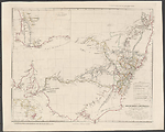
Map Summary Map of the Discoveries in Australia
This map, [Plate] 35 was the first map devoted to Australia which John Arrowsmith prepared for his London Atlas. It shows at a scale of almost 1:3 000 000 the south- eastern portion of the continent now occupied by the states of New South Wales, Victoria, the area of Queensland south of Brisbane and the portion of South Australia eastwards of the Eyre Peninsula. The area was seen at that period of settlement as the most salubrious for Europeans, with its cooler climate and soils more suited to cultivation than the waterless and sandy coasts of south-west Western Australia. The map shows the routes of the explorers, topographical features and place names. The relief is indicated by hachures. The drainage pattern attempts to show the erratic nature of the water supply by broken drainage lines indicating seasonal variation in flow. There are also notes on the nature of the vegetation and the soils and rock types. The main thrust of exploration was also in this region, as the title suggests, so this was to become a pivotal area in the development of the continent.
The map has a large inset at the top left of The Colony of Western Australia at the same scale as the Map, showing early explorations, while at the bottom left there is a smaller inset of Australasia showing the position of Australia and the parts of the continent shown in the main map and larger inset.
The map had a short life of three years, in which it went through five states of which only three added further information to the map. It also appeared in Charles Sturt's two editions of his expedition into the interior (Sturt, 1833). Arrowsmith quickly recognized that because of the amount of information becoming available the scale of the map would not be sufficient for him to incorporate new discoveries adequately.
Although the earliest state found carries the imprint 15 Feb 1832, this state is obviously published much later than that as it shows the journey of Sir Thomas Mitchell the Surveyor General of New South Wales in January and February of 1832. In the table of tracks of the explorers printed above the title Mitchell's name is omitted, which suggests it is a later addition made after the map was completed. If this turns out to be the case the first state of this map is yet to be found. However, as we know from Francis Herbert's work, Arrowsmith had this plate ready to publish in 1832 (Herbert, F, 1989, p. 99). The alternative explanation might be that the information about Mitchell's journey came to hand shortly before Arrowsmith went to press and that although he added this information he neglected to update the imprint and the table of explorers' routes.
At this stage, not having committed too much in terms of labour and engraving time, Arrowsmith decides to produce a new map. He abandons this map and produces a new one at a larger scale of 1:2 660 000 in contrast to the previous scale of 1:3 000 000. The title of this replacement map is The South Eastern Portion of Australia, compiled from the Colonial Surveys and from details furnished by Exploratory Expeditions.
Related entries
Published resources
Books
- Sturt, Charles, Two expeditions into the interior of southern Australia, during the years 1828, 1829, 1830, and 1831 : with observations on the soil, climate and general resources of the colony of New South Wales, 2nd edn, Smith, Elder, London, 1834. Details
Journal Articles
- Herbert, Francis, 'The 'London Atlas of Universal Geography' from John Arrowsmith to Edward Stanford: Origin, Development and Dissolution of a British World Atlas from the 1830s to the 1930s', Imago Mundi, vol. 41, 1989, pp. 98-123. Details
Images
- Title
- Map of the discoveries in Australia, 1832/1
- Type
- Map
- Repository
- National Library of Australia Map Collection
- Title
- Map of the Discoveries in Australia, 1834/1 (1832)
- Type
- Map
- Repository
- National Library of Australia Map Collection
- Title
- Map of the Discoveries in Australia, 1834/2
- Type
- Map
- Repository
- National Library of Australia Map Collection
- Title
- Map of the Discoveries in Australia, 1834/3
- Type
- Map
- Repository
- National Library of Australia Map Collection
Dorothy F. Prescott
Created: 29 July 2010, Last modified: 3 July 2012