
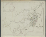
Map State The South Eastern Portion of Australia, 1838/1
The South Eastern Portion of Australia: compiled from the Colonial surveys and from details furnished by exploratory expeditions by John Arrowsmith. [Pl. 35].
Scale 1:2 660 000. S 26° 30'--S 38° 30'/E 136° 30'--E 153° 40'. London, Pubd. 2d. Aug.1838 by John Arrowsmith, 35 Essex Street, Strand.
1 map : col. ; 51.5 x 62.0 cm.
Insets: Top left. [Australia]. -- Table below title: Route of travellers into the interior. -- Counties.
Description
Shows
PLATE NO:
There is no plate number on the first issue
INSET:
Untitled map of Australia
COLONIES:
NEW SOUTH WALES, SOUTH AUSTRALIA
BOUNDARIES:
New South Wales / South Australia
REGIONS:
AUSTRALIA FELIX
TABLE: COUNTIES
Lists the nineteen counties of New South Wales in a numbered table.
TABLE: EXPLORERS' ROUTES
Routes of travellers into the interior.
Lists with area traversed the journeys of [John] Oxley in 1817 and 1818; [Hamilton] Hume 1824; Allan Cunningham in 1825, 1827, 1828-9; [Charles] Sturt in 1828 and 1830; [Thomas Livingstone] Mitchell in 1832, 1835 and 1836, and [Richard] Bourke in 1837.
REFERENCE
T 95
NOTES:
The map described here state 1838/1, appears to be an unfinished release. It lacks all details of Hamilton Hume's and William H. Hovell's overland expedition to Port Phillip as shown in the previous title of plate 35 which was Map of the Discoveries in Australia, although the table of explorers' routes includes a reference to this journey. Likewise it lacks all the new topographical information gathered by Hume and Hovell on this 1824-25 journey.
There are also place names missing from T. L. Mitchell's expedition through Australia Felix.
New South Wales
In this 1838/1 state of the map knowledge of the River Darling has been progressed by two of Mitchell's expeditions, the first down the Darling from Bathurst in July 1835 and the second up the Darling from its junction with the Murray River in May 1836 'Major Mitchell's farthest N May 1836'. A noticeable development of the tributary system of the Darling is appearing. The Bogan R. is shown west of the Macquarie and Dixon's farthest in 1833 (Robert Dixon). Also shown here is a note Mr Cunningham killed by aboriginals hereabout. This refers to Richard Cunningham's death just west of the Bogan, which occurred about 15 April 1835] (Parsons, 1966, p,269)
The previous un-named section of the Great Dividing Range in northern NSW has been removed. The Moneroo or Brisbane Downs of the last state of the 'Discoveries' map is now shown as Moneroo Plains.
Victoria
There is a steadily growing knowledge of the westward flowing river systems emanating from the Australian Alps., viz. the Goulburn, Murray (supposed course), Ovens, Currojalinga or Swampy River, the R. Bayungun and several as yet un-named streams. The supposed source of the R. Murray is now shown as Lake Omio hereabouts on the eastern flank of the Australian Alps. As stated at the beginning of this description, Mitchell's AUSTRALIA FELIX is now shown but only some of the details of his expedition are recorded.
South Australia
In South Australia the eastern coast of the Gulf of St. Vincent shows many new names including Adelaide compared with the last state of the 'Discoveries' map. Mt Lofty reappears. There are more names on Kangaroo Island. The extensive notes along the lower Murray River have been removed and similarly along the river Murrumbidgee. A three line note on Charles Sturt's navigation down the Murray appears at the junction with the Murrumbidgee.
Changes AND ADDITIONS
Noted here are the changes between information portrayed on the last state of the 'Discoveries' map and the first state of the South Eastern Portion of Australia title.
PLATE NO.
There is no plate number on this first issue.
INSET MAP:
Map shows the three colonies of Western Australia, South Australia and New South Wales. Much greater development of the Murray-Darling river system and the westward flowing streams in Victoria appears.
COLONIES:
SOUTH AUSTRALIA appears.
BOUNDARIES:
New South Wales / South Australia shown
REGIONS:
AUSTRALIA FELIX appears.
TABLE: COUNTIES
The county names in New South Wales have been removed from the map and shown in a numbered table.
TABLE: EXPLORERS' ROUTES
Routes of travellers into the interior.
The table is kept but the distances no longer given, just the name of the explorer and the area traversed. No longer shown are Lt. Currie's track and Allan Cunningham's journeys in 1823 and 1825. [Robert] Dixon's route is shown but not entered in table. Mitchell's 1835 and 1836 routes are added.
NOTES:
The map described here appears to be an unfinished release. It lacks all details of Hamilton Hume and William H. Hovell's overland expedition to Port Phillip as shown in the previous title of plate 35 which was Map of the Discoveries in Australia, although the table of explorers' routes includes a reference to this journey. Likewise it lacks all the new topographical information gathered by Hume and Hovell on this 1824-25 journey.
There are also place names missing from T. L. Mitchell's expedition through Australia Felix.
New South Wales
Knowledge of the River Darling has been progressed by two of Mitchell's expeditions, the first down the Darling from Bathurst in July 1835 and the second up the Darling from its junction with the Murray River in May 1836 'Major Mitchell's farthest N May 1836'. A noticeable development of the tributary system of the Darling is appearing. The Bogan R. is shown west of the Macquarie and Dixon's farthest in 1833 (Robert Dixon). Also shown here is a note Mr Cunningham killed by aboriginals hereabout. This refers to Richard Cunningham's death just west of the Bogan, which occurred about 15 April 1835] (Parsons, 1966, p,269)
The previous un-named section of the Great Dividing Range in northern NSW has been removed. The Moneroo or Brisbane Downs of the last state of the 'Discoveries' map is now shown as Moneroo Plains.
Victoria
There is a steadily growing knowledge of the westward flowing river systems emanating from the Australian Alps., viz. the Goulburn, Murray (supposed course), Ovens, Currojalinga or Swampy River, the R. Bayungun and several as yet un-named streams. The supposed source of the R. Murray is now shown as Lake Omio hereabouts on the eastern flank of the Australian Alps. As stated at the beginning of this description, Mitchell's AUSTRALIA FELIX is now shown but only some of the details of his expedition are recorded.
South Australia
In South Australia the eastern coast of the Gulf of St. Vincent shows many new names including Adelaide compared with the last state of the 'Discoveries' map. Mt Lofty reappears. There are more names on Kangaroo Island. The extensive notes along the lower Murray River have been removed and similarly along the river Murrumbidgee. A three line note on Charles Sturt's navigation down the Murray appears at the junction with the Murrumbidgee.
Key Dates
- 1817 - 1837
- Situation date
- 2 August 1838
- Map Publication Date
Related entries
Timeline
The South Eastern Portion of Australia, 1838/1
The South Eastern Portion of Australia, 1838/2
The South Eastern Portion of Australia, 1838/3
The South Eastern Portion of Australia, 1838/4
The South Eastern Portion of Australia, 1838/5 (1857)
The South Eastern Portion of Australia, 1841/1
The South Eastern Portion of Australia, 1842/1
The South Eastern Portion of Australia, 1844/1 (1842/2)
The South Eastern Portion of Australia, 1848/1
The South Eastern Portion of Australia, 1852/1
The South Eastern Portion of Australia, 1853/1
The South Eastern Portion of Australia, 1860/1 (1858/1)
Institutional and Other Holdings
National Library of Australia Map Collection
Published resources
Books
- Tooley, Ronald Vere, The mapping of Australia and Antarctica, Holland Press, London, 1985, 649 pp. Details
Book Sections
- Parsons, Vivienne, 'Cunningham, Richard (1793 - 1835?)', in Australian Dictionary of Biography, vol. 1, Melbourne University Press, Melbourne, 1966, pp. 268-269. http://adb.anu.edu.au/biography/cunningham-richard-1943. Details
Images
- Title
- The South Eastern Portion of Australia, 1838/1
- Type
- Map
- Repository
- National Library of Australia Map Collection
Dorothy F. Prescott
Created: 10 September 2010, Last modified: 3 July 2012