
Map State Cockburn Sound, 1833/2
Cockburn Sound / by J.S. Roe, Esqr., Survr. Genl.. of the Colony of Western Australia.
With: King Georges Sound with its harbours; from Captn. Flinders' Survey, (1802) improved by documents in the Colonial Office to1833 and With: Discoveries in Western Australia from documents furnished to the Colonial Office by J. S. Roe, Esqre. Surv. Genl.
Scale 1 in. = 1.5 nm. [ca.1: 110,000] and Scale [ca. 1:90 000] and Scale [ca. 1:970 000 at S 35°]
London, Pubd. May 31st 1833, by J. Arrowsmith, 33 East St., Red Lion Square and London, Pubd. May 31st 1833, by J. Arrowsmith, 33 East St., Red Lion Square and London, Pubd. May 31st 1833 by J. Arrowsmith, 35 Essex Street, Strand.
3 maps on 1 sheet : mounted on linen, col. ; 50.0 x 60.5 cm. and 28.5 x 31.0 cm. and 23.0 x 31.0 cm. combined on a sheet 55.0 x 98.0 cm.
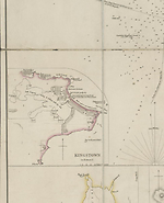
Inset: Kingstown (in Rottnest Island). Scale 1" = 40 chains. [ca. 1: 31 680].
See KING GEORGES SOUND for a description of the lower chart on this sheet and DISCOVERIES IN WESTERN AUSTRALIA state 1833/4
Description
Shows:
TITLE:
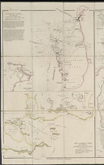
Top left hand side of sheet. Beneath this is found the scale and details of tides.
Then a paragraph follows beneath the scale of nautical directions. Beneath the first title on this sheet, i.e. Cockburn Sound, is a further paragraph headed Additional Instructions, by His Excellency Sir Jas. Stirling, Captn. R. N' which gives further details of winds in various seasons, and instructions for entering Cockburn Sound and Gage Road
PLATE NO:
36
IMPRINT:
London, Pubd. May 31st 1833, by J. Arrowsmith, 33 East St., Red Lion Square.
INSET:
Kingstown: Shows Kingstown on Rottnest Island
Kingstown has added in parentheses (in Rottnest I.) A linear scale has been added. Scale
40 chains to 1 inch [ca 1: 31 680]
REFERENCE
Not in Tooley
NOTES
The chart extends from the mouth of the Swan River south to Cape Peron and includes the waters west of Gage Roads and Garden Island.
On the coast of the mainland in Cockburn Sound the site of Clarence has been added south of Brown Hill.
Changes AND ADDITIONS
This state is found as three maps on one sheet, i.e. Cockburn Sound and King Georges Sound along with Discoveries in Western Australia. In this three-map format the sheet carries the plate number '36'.
TITLE:
Discoveries in Western Australia (the largest map) is the third title added to the previous two.
Beneath the first title on this sheet, i.e. Cockburn Sound, is a further paragraph headed Additional Instructions, by His Excellency Sir Jas. Stirling, Captn. R. N' which gives further details of winds in various seasons, and instructions for entering Cockburn Sound and Gage Road.
PLATE NO:
36.
In this combination state two plates have been used, placed alongside each other. The normal plate 36 is Discoveries in Western Australia. It is not clear whether or not some later agency mounted both sheets together or whether they were actually issued by Arrowsmith in this format. The National Library of Australia's copy in this format is MAP RM 2653. This state has been seen offered for sale which suggests that it may have emanated from Arrowsmith's establishment in this format originally.
IMPRINT:
In this state Arrowsmith's imprint appears as London, Pubd. May 31st 1833, by J. Arrowsmith, 33 East St., Red Lion Square. It is also the date for the third map. However see address below.
ADDRESS:
Remains as 33 East Street, Red Lion Square for the two smaller maps but for the third large map i.e. Discoveries in Western Australia the address is 35 Essex Street, Strand.
INSET:
Kingstown: Has added in parentheses (in Rottnest I.) A linear scale has been added. Scale 40 chains to 1 inch [ca. 1:31 680]
NOTES
On the coast of the mainland in Cockburn Sound the site of Clarence has been added south of Brown Hill.
Key Dates
- 1826 - 1833
- Situation date
- 31 May 1833
- Map Publication Date
Institutional and Other Holdings
National Library of Australia Map Collection
- Discoveries in Western Australia [cartographic material] : from documents furnished to the Colonial Office by J.S Roe, Esqre. Surv. Genl., MAP RM 2653; National Library of Australia Map Collection. Details
Royal Geographical Society
- Cockburn Sound, 1833, mr Australia S/S.36; Royal Geographical Society. Details
State Library of Western Australia
- Cockburn Sound [cartographic material] / by J.S. Roe. King Georges Sound with its harbours, from Captn. Flinders survey (1802) improved by documents in the Colonial Office to 1833., 1833, 24/5/5 (1833) RARE; State Library of Western Australia. Details
Published resources
Books
- Tooley, Ronald Vere, The mapping of Australia and Antarctica, Holland Press, London, 1985, 649 pp. Details
Images
Dorothy F. Prescott
Created: 4 August 2010, Last modified: 6 March 2013