
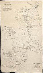
Map State Cockburn Sound, 1833/1
Cockburn Sound / by J.S. Roe, Esqr., Survr. Genl.. of the Colony of Western Australia.
With: King Georges Sound with its harbours; from Captn. Flinders' Survey, (1802) improved by documents in the Colonial Office to 1833.
Scale 1 in. = 1.5 nm. [ca.1: 110,000].
[London, Pubd. May 31st 1833, by J. Arrowsmith, 33 East St., Red Lion Square.]
2 maps on 1 sheet : mounted on linen, col. ; 28.5 x 31.0 cm. and 22.5 x 31.0 cm.
Insets: Kingstown (in Rottnest Island).
See KING GEORGES SOUND for a description of the lower chart on this sheet
Description
Shows:
TITLE:
Top left hand side of sheet. Beneath this is found the scale and details of tides.
Then a paragraph follows beneath the scale of nautical directions.
PLATE NO:
None
IMPRINT:
None
The copy seen had no imprint or plate number but appears from the style, layout and internal information to have originated in Arrowsmith's establishment.
INSET:
Kingstown: Shows Kingstown on Rottnest Island.
REFERENCE
Not in Tooley
NOTES
The chart extends from the mouth of the Swan River south to Cape Peron and includes the waters west of Gage Roads and Garden Island.
Key Dates
- 1826 - 1833
- Situation date
- 31 May 1833
- Map Publication Date
Institutional and Other Holdings
National Library of Australia Map Collection
- Cockburn Sound [cartographic material] : King Georges Sound with its harbours / by J.S. Roe, Esq., Survr. Genl. of the Colony of Western Australia ; from Captn. Flinders survey (1802) improved by documents in the Colonial Office to 1833, MAP NK 11133; National Library of Australia Map Collection. Details
Published resources
Books
- Tooley, Ronald Vere, The mapping of Australia and Antarctica, Holland Press, London, 1985, 649 pp. Details
Images
- Title
- Cockburn Sound 1833/1 and King Georges Sound 1833/1
- Type
- Map
- Repository
- National Library of Australia Map Collection
Dorothy F. Prescott
Created: 4 August 2010, Last modified: 6 March 2013