
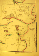
Map State King Georges Sound, 1840/1
King Georges Sound with its harbours: from Captn. Flinders Survey, (1802) improved by documents in the Colonial Office to 1833. With: Cockburn Sound by J. S. Roe, Esqr. Survr. Genl. of the Colony of Western Australia.
Scale [ca. 1: 90 000]. London, Pubd. Jany. [space] 1840, by J. Arrowsmith, 10 Soho Square.
2 maps on 1 sheet : mounted on linen, col. ; 23.4 x 31.0 cm. and 28.5 x 31.0 cm.
Insets: [Albany and environs] Scale [ca. 1: 31 680]. -- Survey of the coast about Peel Harbour by J. S. Roe, 1838.
Description
Shows:
TITLE:
The title has been moved to the top left of the lower portion of the map sheet.
PLATE NO:
[35a]
This is the plate number assigned to the Library of Congress plate which is a loose sheet map in the London Atlas of Universal Geography dated 1840
INSET:
[Albany and environs]: Appears to the top right of the King Georges Harbour portion of the map sheet.
Shows layout of the streets of Albany and allotments on Strawberry Hill and near Middleton Bay with a projected road linking Albany with Middleton Bay.
The Albany inset shows many more blocks of land and the main streets are named. A road to the east along the coast of Hanover Bay from Albany is named Brunswick Road and another going north and then east from Albany is named Middleton Road. On the south side of Middleton Road a row of suburban allotments has been laid out while north of this road two large blocks are assigned to Sir B. Spencer and one to J. Hanson. East of this L. Seppings (fresh) is named. South of the name 'Middleton Bay' a cove is named Ellen Cove.
INSET:
Peel Harbour: Appears directly beneath the Albany inset
Survey of the coast about Peel Harbour by J. S. Roe, Esqr, Surv. Genl., 1838. It shows the southern part of Cockburn Sound and part of Garden Island and south showing Mangles Bay , Cape Peron, Peel Harbour and Warnbro' Sound with rocks, soundings and shallow areas.
MARGIN:
In the margin beneath this last inset is a three line description of winds and tides in Peel Harbour.
REFERENCE
Not in Tooley
NOTES
Shows King Georges Sound from Matthew Flinders' original survey with the track of his ship with many soundings in the Sound, Princess Royal Harbour and Oyster Harbour but updated from later information.
Changes AND ADDITIONS
TITLE:
The title has been moved to the top left of the lower portion of the map sheet.
PLATE NO:
[35a]
INSET:
[Albany and environs]
The Albany inset shows many more blocks of land and the main streets are named. A road to the east along the coast of Hanover Bay from Albany is named Brunswick Road and another going north and then east from Albany is named Middleton Road. On the south side of Middleton Road a row of suburban allotments has been laid out while north of this road two large blocks are assigned to Sir B. Spencer and one to J. Hanson. East of this L .Seppings (fresh) is named. South of the name 'Middleton Bay' a cove is named Ellen Cove.
INSET:
Peel Harbour: Appears directly beneath the Albany inset.
Survey of the coast about Peel Harbour by J. S. Roe, Esqr, Surv. Genl., 1838.
It shows the southern part of Cockburn Sound and part of Garden Island and south showing Mangles Bay, Cape Peron, Peel Harbour and Warnbro' Sound with rocks, soundings and shallow areas.
MARGIN:
In the margin beneath this last inset is a three line description of winds and tides in Peel Harbour.
Key Dates
- 1802 - 1839
- Situation date
- 31 May 1840
- Map Publication Date
Related entries
Timeline
King Georges Sound, 1833/1
King Georges Sound, 1833/2
King Georges Sound, 1840/1
Institutional and Other Holdings
Library of Congress, Geography and Map Division
- The London Atlas of Universal Geography, exhibiting the physical & political divisions of the various countries of the world, constructed from original materials, 1840, G1019 .A8 1840 Vault fol. Copy 1; Library of Congress, Geography and Map Division. Details
Published resources
Books
- Tooley, Ronald Vere, The mapping of Australia and Antarctica, Holland Press, London, 1985, 649 pp. Details
Images
- Title
- Inset maps of Albany and Peel Harbour
- Type
- Map
- Repository
- Library of Congress, Geography and Map Division
Dorothy F. Prescott
Created: 4 August 2010, Last modified: 3 July 2012