
Map State Van Diemens Land, 1832/4 (1834/3)
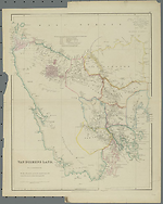
Van Diemens Land by J. Arrowsmith. [Pl.] 37. London, Pubd. 15 Feby. 1834 by J. Arrowsmith, 10 Soho Square. Scale [ca.1: 633 600]. -- 1 map : col. ; 60 x 49.5 cm.
Description
Shows:
PLATE NO:
37
IMPRINT:
Address changed to 10 Soho Square. Imprint reads London, Pubd. 15 Feby. 1834 by J. Arrowsmith, 10 Soho Square.
POLICE DISTRICTS:
LAUNCESTON, NORFOLK PLAINS, CAMPBELL TOWN, OATLANDS, OYSTER BAY, CLYDE, NEW NORFOLK, RICHMOND and HOBART TOWN
V.D.L. Co's GRANTS:
WOOLNORTH, CIRCULAR HEAD, HAMPSHIRE HILLS, MIDDLESEX PLAINS, SURREY HILLS and land in three islands named TREFOIL, WALKER'S & ROBBINS ISLANDS
TABLE:
The following arrangements for the Grants to the Van Diemen's Land Company have been determined upon.
Acreages are given for the above listed areas in all totalling 350 000 acres.
The information is superimposed on a topographic base with relief shown by hachures. The map carries notes on vegetation and soils and some historical notes on discovery.
Reference
T 118
CHANGES AND ADDITIONS
IMPRINT:
Address changed to 10 Soho Square. Imprint reads London, Pubd. 15 Feby. 1834 by J. Arrowsmith, 10 Soho Square.
Key Dates
- 1828 - 1830
- Situation date
- 15 February 1834
- Map Publication Date
Related entries
Timeline
Van Diemens Land, 1832/1
Van Diemens Land, 1832/2 (1834/1)
Van Diemens Land, 1832/3 (1834/2)
Van Diemens Land, 1832/4 (1834/3)
Van Diemens Land, 1832/5 (1840/1)
Van Diemens Land, 1832/6 (1842/1)
Institutional and Other Holdings
British Library Map Library
- The London Atlas of Universal Geography ... by ... John Arrowsmith, 1858, Maps 41.f.13.; British Library Map Library. Details
Library of Congress, Geography and Map Division
- The London Atlas of Universal Geography, exhibiting the physical & political divisions of the various countries of the world, constructed from original materials, 1840, G1019 .A8 1840 Vault fol. Copy 1; Library of Congress, Geography and Map Division. Details
National Library of Australia Map Collection
- Van Diemens Land [cartographic material] / by J. Arrowsmith, MAP T 118; National Library of Australia Map Collection. Details
Sir George Grey Special Collections, Auckland Libraries
- Van Diemens Land [cartographic material] / by J. Arrowsmith., 1834, 994.6 A77; Sir George Grey Special Collections, Auckland Libraries. Details
State Library of Western Australia
- The London Atlas of Universal Geography, exhibiting the physical & political divisions of the various countries of the world, constructed from original materials [cartographic material] / John Arrowsmith., 1840, 1019 Rare Room 1; State Library of Western Australia. Details
Published resources
Books
- Tooley, Ronald Vere, The mapping of Australia and Antarctica, Holland Press, London, 1985, 649 pp. Details
Images
- Title
- Van Diemens Land, 1832/4 (1834/3)
- Type
- Map
- Repository
- National Library of Australia Map Collection
Dorothy F. Prescott
Created: 3 August 2010, Last modified: 3 July 2012