
Map State South Australia shewing the division into counties of the settled portions of the Province, 1846/1
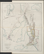
South Australia shewing the division into counties of the settled portions of the Province, with situation of mines of copper and lead, from the Surveys of Captn. Frome Rl. Engrs. Survr. Genl. Of the Colony 1842. / John Arrowsmith. Scale [ca. 1:950 000 at 34° S]. London, Pubd.20 March 1846, by John Arrowsmith, 10 Soho Square for Dutton's "South Australia and its Mines". --1 map : col. ; 60 x 49 cm. Insets: [Australia]. -- Plan of Port Adelaide with soundings added 1846.
Description
Shows
TITLE:
The title is amended by the insertion of the words 'with situation of mines of copper and lead'.
IMPRINT:
The imprint now reads 'London, Pubd. 20 March 1846, by John Arrowsmith,…for Dutton's "South Australia and its Mines"
Some issues have been seen with paste-over labels such as Sold by J. Wyld, Geographer to the Queen, Charing Cross East, four doors from Trafalgar Square
INSETS:
[Australia]. - Plan of Port Adelaide with soundings added 1846.
MARGINAL NOTE:
The mineral localities shown in red
COUNTIES:
FLINDERS, STANLEY, LIGHT, EYRE, GAWLER, ADELAIDE, STURT, HINDMARSH and RUSSELL
EXPLORERS' ROUTES:
[Edward John] Eyre's tracks of 1839 and 1840 are shown and also the tracks dated 1842 of Edward Charles Frome in the Fleurieu Peninsula. [Thomas] Burr's track dated 1840 shown. Burr was Deputy Surveyor-General in the South Australian Survey Department.
REFERENCE
Not in Tooley
F 4267 Dutton, Francis South Australia and its mines. London, T & W. Boone 1846.
NOTES:
Shows the area south of 31°30'S and from the Eyre Peninsula eastwards to the Coorong. Relief is shown by 'hairy caterpillar' hachuring. Nine counties are delimited.
The map now shows mineral localities and mines.
Changes AND ADDITIONS
TITLE:
Amended to read 'South Australia, shewing the division into counties of the settled portions of the province, with situation of mines of copper and lead, from the surveys of Captn. Frome…1844.'
MARGINAL SERIES TITLE:
Papers relative to South Australia removed.
IMPRINT:
Now reads London, Pubd. 20 March 1846, by John Arrowsmith, 10 Soho Square for Dutton's "South Australia and its Mines".
INSETS:
Added as above.
[Australia] Shows an outline of the continent with the boundaries of the Colony of South Australia indicated
The Plan of Port Adelaide shows the soundings as at low water. Proposed building lots are also demarcated.
MARGINAL NOTE:
The mineral localities shown in red
NOTES:
The map now shows mineral localities and mines.
There are issues of this state with paste-over label indicating the map was sold by J. Wyld, eg. London, John Arrowsmith,10 Soho Square. Sold by J. Wyld, Geographer to the Queen, Charing Cross East, four doors from Trafalgar Square
Key Dates
- 1836 - 1846
- Situation date
- 20 March 1846
- Map Publication Date
Related entries
Timeline
South Australia shewing the division into counties of the settled portions of the Province, 1843/1
South Australia shewing the division into counties of the settled portions of the Province, 1843/2
South Australia shewing the division into counties of the settled portions of the Province, 1846/1
South Australia shewing the division into counties of the settled portions of the Province, 1858/1
Institutional and Other Holdings
Mitchell Map Collection, State Library of New South Wales
- South Australia shewing the division into counties of the settled portions of the province with situation of mines of copper & lead [cartographic material] : from the survey of Captn. Frome, Rl. Engrs., Survr. Genl. of the Colony, 1844 / John Arrowsmith., 1844, Z/M2 830gbf/1846/1; Mitchell Map Collection, State Library of New South Wales. Details
National Library of Australia Map Collection
- South Australia shewing the division into counties of the settled portions of the province with situation of mines of copper & lead [cartographic material] : from the survey of Captn. Frome, Rl. Engrs., Survr. Genl. of the Colony, MAP RM 1136; National Library of Australia Map Collection. Details
- South Australia shewing the division into counties of the settled portions of the province with situation of mines of copper & lead [cartographic material] : from the survey of Captn. Frome, Rl. Engrs., Survr. Genl. of the Colony, 1844 / John Arrowsmith, 1846, MAP RM 2625; National Library of Australia Map Collection. Details
Sir George Grey Special Collections, Auckland Libraries
- South Australia shewing the division into counties of the settled portions of the province with situation of mines of copper & lead [cartographic material] : from the survey of Captn. Frome Rl. Engrs. Survr. Genl. of the Colony 1844, 994.2 A77; Sir George Grey Special Collections, Auckland Libraries. Details
State Library of Queensland
- South Australia shewing the divisions into counties of the settled portions of the province with situation of mines of copper & lead, 1844, MAPS 830 1844 00000 R; State Library of Queensland. Details
State Library of South Australia
- South Australia shewing the division into counties of the settled portions of the province with situation of mines of copper & lead [cartographic material] : from the survey of Captn. Frome, Rl. Engrs., Survr. Genl. of the Colony, 1844, 1846, C 993; State Library of South Australia. Details
State Library of Victoria, Maps Collection
- South Australia shewing the division into counties of the settled portions of the province with situation of mines of copper & lead [cartographic material] : from the survey of Captn. Frome, Rl. Engrs., Survr. Genl. of the Colony, 1844 / John Arrowsmith., MAPS 830 FB 1844; State Library of Victoria, Maps Collection. Details
The University of Melbourne Library, Eastern Resource Centre Map Collection
- South Australia shewing the division into counties of the settled portions of the province with situation of mines of copper & lead [cartographic material] : from the survey of Captn. Frome Rl. Engrs. Survr. Genl. Of the Colony 1844, UniM ERC MAPS MX 830 fb 1844; The University of Melbourne Library, Eastern Resource Centre Map Collection. Details
Published resources
Books
- Dutton, Francis, South Australia and its mines : with an historical sketch of the colony, under its several administrations, to the period of Captain Grey's departure, T. and W. Boone, London, 1846. Details
- Ferguson, John Alexander, Bibliography of Australia, Angus and Robertson, Sydney, 1941-1969. Details
Images
- Title
- South Australia shewing the division into counties of the settled portions of the Province, 1846/1
- Type
- Map
- Repository
- National Library of Australia Map Collection
- Title
- South Australia shewing the division into counties of the settled portions of the Province, 1846/1
- Type
- Map
- Repository
- National Library of Australia Map Collection
Dorothy F. Prescott
Created: 10 September 2010, Last modified: 28 August 2013