
Map State South Australia shewing the division into counties of the settled portions of the Province, 1843/1
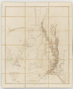
South Australia shewing the division into counties of the settled portions of the Province from the Surveys of Captn. Frome R l. Engrs. Survr. Genl. of the Colony 1842. / John Arrowsmith. Scale [ca. 1:950 000 at 34° S]. London, Pubd. 10th July 1843 by John Arrowsmith, 10 Soho Square. -- 1 map : col. ; 61 x 49cm. on sheet 68 x 57cm.
Description
Shows
COUNTIES:
FLINDERS, STANLEY, LIGHT, EYRE, GAWLER, ADELAIDE, STURT, HINDMARSH and RUSSELL
EXPLORERS' ROUTES:
[Edward John] Eyre's tracks of 1839 and 1840 are shown and Captain [Edward Charles] Frome's tracks of Sept. 1842 also [Thomas] Burr's track dated 1840. Burr was Deputy Surveyor General of the South Australia Survey Department.
REFERENCE:
Not in Tooley
NOTES
Shows the area south of 31°30'S and from the Eyre Peninsula eastwards to the Coorong. Relief shown by 'hairy caterpillar' hachuring. Nine counties are shown.
Key Dates
- 1836 - 1842
- Situation date
- 10 July 1843
- Map Publication Date
Related entries
Timeline
South Australia shewing the division into counties of the settled portions of the Province, 1843/1
South Australia shewing the division into counties of the settled portions of the Province, 1843/2
South Australia shewing the division into counties of the settled portions of the Province, 1846/1
South Australia shewing the division into counties of the settled portions of the Province, 1858/1
Institutional and Other Holdings
Dixson Map Collection, State Library of New South Wales
- South Australia shewing the division into counties of the settled portions of the province [cartographic material]from the survey of Captn. Frome, Rl. Engrs., Survr. Genl. of the Colony, 1842 / John Arrowsmith, 10 Soho Square., 1843, 84/153; Dixson Map Collection, State Library of New South Wales. Details
Published resources
Books
- Tooley, Ronald Vere, The mapping of Australia and Antarctica, Holland Press, London, 1985, 649 pp. Details
Images
- Title
- South Australia shewing the division into counties of the settled portions of the Province, 1843/1
- Type
- Map
- Repository
- Dixson Map Collection, State Library of New South Wales
Dorothy F. Prescott
Created: 10 September 2010, Last modified: 3 September 2012