
Map State The District of Adelaide, South Australia, 1839/2
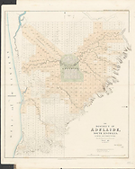
The district of Adelaide, South Australia: as divided into country sections from the trigonometrical surveys of Colonel Light, late Survr. Genl / John Arrowsmith 35 Essex Street 1839. London, Published Feby. 18th. 1839, by John Arrowsmith, 35 Essex Street, Strand. James, Luke G. and Luke J. Hansard, Printers. -- Scale [ca. 1:43 500]. Scale 1" = 55 chains. -- 1 map : col. ; 62.0 x 51.0 cm. Marginal title: Third Annual Report of the South Australia Colonization Commissioners.
Description
Shows
TITLE:
Lower right hand corner of map.
PLATE NO:
None. It does not at any stage appear to have had a plate number printed on the face
IMPRINT:
Remains as London, Published Feby. 18th. 1839, by John Arrowsmith, 35 Essex Street, Strand.
PRINTER:
Lower right beneath neat-line: James, Luke G. & Luke J. Hansard Printers
MARGINAL TITLE:
This title appears in the top right-hand corner outside the neat-line: Third Annual Report of the South Australia Colonization Commissioners
LANDHOLDERS
The map identifies purchasers of land sections
REFERENCE:
F 2735 Colonization Commissioners for South Australia.
Third annual report of the Colonization Commissioners for South Australia to Her majesty's Principal secretary for the Colonies. 1838… Ordered by the House of Commons to be printed 13 May 1839. (255)
Not in Tooley
NOTES
The map appears first as a normal Arrowsmith publication with the imprint shown as from his premises in 35 Essex Street.. The map is a cadastral plan of the area immediately surrounding Adelaide and covers an area from Port Adelaide in the north down to present day Brighton in the south (5 km beyond Glenelg which is shown on this map).
In Adelaide the map shows the roads, canals, schools, store, barracks, cemetery and hospital. It also shows surveyed sections numbered and available for sale in two sizes, small lots of 80 acres and large lots of 134 acres. Those sold are coloured and carry the landholders' names. The numbering system of surveyed lots is by two parallel sequences of numbers not immediately apparent unless the accompanying list of purchasers is available. Trigonometrical survey stations are marked.
There is an indication to prospective buyers of areas where the streams dry up in summer. The relief is shown by hachures and hill shading and vegetation is indicated.
Tributaries of the River Torrens are shown.
This is the first indication that the map has been published officially. Note the printer statement of the Hansards below the neat-line bottom right and the addition of an official map title indicating the Report in which the map appeared. A new printing by the Hansards, official printers to the House of Commons.
In this 1839/2 state of the map indications of a government issue are the printers' statement and the additional report title added to the top margin.
CHANGES AND ADDITIONS
PRINTER:
A printer statement appears James, Luke G. & Luke J., Hansard Printers
MARGINAL TITLE:
This additional title appears in the top right hand corner outside the neat-line.
Third Annual Report of the South Australia Colonization Commissioners.
NOTES
A new printing by the Hansards, official printers to the House of Commons. This map occurs also in:
Great Britain. Parliament. House of Commons.
The Sessional Papers printed by order of the House of Commons …1839 … Vol. XVII. Map f. p. 60. VUSpC/BX f 328.41 GREA Map missing, seen in 1992.
Key Dates
- 1837 - 1839
- Situation date
- 18 February 1839
- Map Publication Date - Actually May 1839
Related entries
Timeline
The District of Adelaide, South Australia, 1839/1
The District of Adelaide, South Australia, 1839/2
The District of Adelaide, South Australia, 1839/3
The District of Adelaide, South Australia, 1839/4
The District of Adelaide, South Australia, 1839/5
The District of Adelaide, South Australia, 1840/1
The District of Adelaide, South Australia, 1841/1
The District of Adelaide, South Australia, 1841/2
The District of Adelaide, South Australia, 1841/3
Institutional and Other Holdings
Mitchell Map Collection, State Library of New South Wales
- The District of Adelaide, South Australia [cartographic material] : as divided into county sections, from the trigonometrical surveys of Colonel Light late Survr. Genl. / John Arrowsmith., 1839, Z/M2 831.112/1839/1; Mitchell Map Collection, State Library of New South Wales. Details
National Library of Australia Map Collection
- The District of Adelaide, South Australia [cartographic material] : as divided into country sections, from the trigonometrical surveys of Colonel Light, late Survr. Genl. / John Arrowsmith, 35 Essex Street, MAP RM 1125; National Library of Australia Map Collection. Details
Published resources
Books
Images
- Title
- The District of Adelaide, South Australia, 1839/2
- Type
- Map
- Repository
- National Library of Australia Map Collection
Dorothy F. Prescott
Created: 10 September 2010, Last modified: 3 July 2012