
Map State The District of Adelaide, South Australia, 1841/3
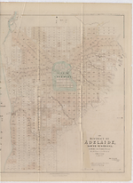
The district of Adelaide, South Australia: as divided into country sections from the trigonometrical surveys of Colonel Light, late Survr. Genl / John Arrowsmith 10 Soho Square 1839. London, Published Feby 18th 1840, by John Arrowsmith, 10 Soho Square.
Ordered to be printed June 21st. 1841. -- Scale [ca. 1:43 500]. Scale 1" = 55 chains. -- 1 map : col. ; 62.0 x 51.0 cm. Marginal title: Appendix to Report from the Select Committee on South Australia. No. 2.
Description
Shows
TITLE:
Lower right-hand corner of map. The statement of responsibility reads: John Arrowsmith 10 Soho Square 1839.
PLATE NO:
None. It does not at any stage appear to have had a plate number printed on the face
IMPRINT:
The imprint reads London, Published Feby 18th 1840, by John Arrowsmith, 10 Soho Square and under this a second imprint, Ordered to be Printed June 21st 1841.
PAPER NO.
A House of Lords Paper No. (174) in lower left margin
MARGINAL TITLE:
Top right hand corner outside neat-line: Appendix to Report from Select Committee on South Australia No. 2.
KEY:
Outside top left hand corner of neat-line is a 4 line key to landholders showing, A= South Australian Company, B= Jno. A. Smith, PR= Public Reserve, GR = Government Reserve.
LANDHOLDERS
The map identifies purchasers of land sections
REFERENCE
F 3221 Great Britain and Ireland - Parliament -South Australia - Reports from Select Committee
Reports from the Select Committee on South Australia: together with Minutes of Evidence, Appendix and Index. Ordered to be printed 21st June 1841. (174)
F 2964a [Dawson, Robert Kearsley] Report on surveying considered with reference to New Zealand and applicable to the Colonies generally. London, Printed by W. Clowes and Sons, Stamford Street For Her Majesty's Stationery Office. 1840.
Not in Tooley
NOTES
The map appears first as a normal Arrowsmith publication with the imprint shown as from his premises in 35 Essex Street. The map is a cadastral plan of the area immediately surrounding Adelaide and covers an area from Port Adelaide in the north down to present day Brighton in the south (5 km beyond Glenelg which is shown on this map).
In Adelaide the map shows the roads, canals, schools, store, barracks, cemetery and hospital. Also shows surveyed sections numbered and available for sale in two sizes, small lots of 80 acres and large lots of 134 acres. Those sold are coloured and carry the landholders' names. The numbering system of surveyed lots is by two parallel sequences of numbers not immediately apparent unless the accompanying list of purchasers is available. Trigonometrical survey stations are marked.
There is an indication to prospective buyers of areas where the streams dry up in summer. The relief is shown by hachures and hill shading and vegetation is indicated.
Tributaries of the River Torrens are shown.
The 1839/2 state is the first indication that the map has been published officially.
In the 1839/3 issue there is now a clear statement of a Parliamentary printing, whereas in 1839/2 this is implied by the printer statement of the Hansards and the use of an official title statement of a Parliamentary Committee Report.
In the 1839/4 issue a Hansard printer statement appears.
In the 1839/5 Lords issue the printer statement is lacking.
The 1840/1 issue is a new Arrowsmith state of the map.
The 1841/1 state is the first official use of the 1840 map by another Parliamentary Committee.
The 1841/2 issue has a House of Commons Paper number (394) added in lower left margin.
The 1841/3 state is a command imprint with a Lord's paper no. 174
Changes AND ADDITIONS
IMPRINT:
As for state 1841/1 state but second imprint reads:
Ordered to be printed June 21st. 1841.
PRINTER:
Hansard Printer statement lacking
PAPER NO:
The House of Lords Paper number (174) is found in the lower left margin beneath the map.
NOTES
This map appears in :
Great Britain. Parliament. House of Commons. Select Committee on South Australia
Reports from the Select Committee on South Australia : together with Minutes of Evidence, appendix and index. [London : House of Commons?], 1841. Spine title: British Parliamentary Papers. South Australia. 1841. Map f. p. 354 VU SpC/AX f 994.2 E58 Copy 2. This map is the Lords' printing with paper number 174.
Key Dates
- 1838 - 1840
- Situation date
- 21 June 1841
- Map Publication Date
Related entries
Timeline
The District of Adelaide, South Australia, 1839/1
The District of Adelaide, South Australia, 1839/2
The District of Adelaide, South Australia, 1839/3
The District of Adelaide, South Australia, 1839/4
The District of Adelaide, South Australia, 1839/5
The District of Adelaide, South Australia, 1840/1
The District of Adelaide, South Australia, 1841/1
The District of Adelaide, South Australia, 1841/2
The District of Adelaide, South Australia, 1841/3
Institutional and Other Holdings
The University of Melbourne Library, Special Collections
- Reports from the Select Committee on South Australia : together with the minutes of evidence, appendix, and index., UniM Bail SpC/AX f 994.2 E58; The University of Melbourne Library, Special Collections. Details
Published resources
Books
Images
- Title
- The District of Adelaide, South Australia, 1841/3
- Type
- Map
- Repository
- The University of Melbourne Library, Special Collections
Dorothy F. Prescott
Created: 10 September 2010, Last modified: 20 September 2012