
Map State The District of Adelaide, South Australia, 1839/1
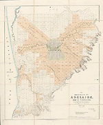
The district of Adelaide, South Australia: as divided into country sections from the trigonometrical surveys of Colonel Light late Survr Genl / John Arrowsmith 35 Essex Street 1839. London, Published Feby. 18th. 1839, by John Arrowsmith, 35 Essex Street, Strand. -- Scale [ca. 1:43 500]. Scale 1" = 55 chains. -- 1 map : col. ; 62.0 x 51.0 cm.
Description
Shows
TITLE:
Lower right hand corner of map.
PLATE NO:
None. It does not at any stage appear to have had a plate number printed on the face
LANDHOLDERS
The map identifies purchasers of land sections
REFERENCE
Not in Tooley
NOTES
The map appears first as a normal Arrowsmith publication with the imprint shown as from his premises in 35 Essex Street. The map is a cadastral plan of the area immediately surrounding Adelaide and covers an area from Port Adelaide in the north down to present day Brighton in the south (5 km beyond Glenelg which is shown on this map).
In Adelaide the map shows the roads, canals, schools, store, barracks, cemetery and hospital. It also shows surveyed sections numbered and available for sale in two sizes, small lots of 80 acres and large lots of 134 acres. Those sold are coloured and carry the landholders' names. The numbering system of surveyed lots is by two parallel sequences of numbers not immediately apparent unless the accompanying list of purchasers is available. Trigonometrical survey stations are marked.
There is an indication to prospective buyers of areas where the streams dry up in summer. The relief is shown by hachures and hill shading and vegetation is indicated.
Tributaries of the River Torrens are shown.
Key Dates
- 1837 - 1838
- Situation date
- 18 February 1839
- Map Publication Date
Related entries
Timeline
The District of Adelaide, South Australia, 1839/1
The District of Adelaide, South Australia, 1839/2
The District of Adelaide, South Australia, 1839/3
The District of Adelaide, South Australia, 1839/4
The District of Adelaide, South Australia, 1839/5
The District of Adelaide, South Australia, 1840/1
The District of Adelaide, South Australia, 1841/1
The District of Adelaide, South Australia, 1841/2
The District of Adelaide, South Australia, 1841/3
Institutional and Other Holdings
Bodleian Library
- The District of Adelaide, South Australia; as divided into country sections, [cartographic material], 1839, 824.112 t.1; Bodleian Library. Details
Mitchell Map Collection, State Library of New South Wales
- The District of Adelaide, South Australia [cartographic material] : as divided into country sections / John Arrowsmith ; from the trigonometrical surveys of Colonel Light 1839., 1839, ZMC 831.112/1839/1; Mitchell Map Collection, State Library of New South Wales. Details
National Library of Australia Map Collection
- The District of Adelaide, South Australia [cartographic material] : as divided into country sections / from the trigonometrical surveys of Colonel Light, late Survr. Genl. ; John Arrowsmith, 35 Essex St., 1839, MAP RM 1122; National Library of Australia Map Collection. Details
Royal Geographical Society
- The District of Adelaide, South Australia as divided into Country Sections from the Trigonometrical Surveys of Colonel Light, mr Australia S.366; Royal Geographical Society. Details
State Library of South Australia
- The District of Adelaide, South Australia [cartographic material] : as divided into country sections / from the trigonometrical surveys of Colonel Light, late Survr. Genl. ; John Arrowsmith, 35 Essex St., 1839, 1839, rbr 325038; State Library of South Australia. Details
- The District of Adelaide, South Australia [cartographic material] : as divided into country sections / from the trigonometrical surveys of Colonel Light, late Survr. Genl. ; John Arrowsmith, 35 Essex St., 1839, 1839, C 893; State Library of South Australia. Details
Published resources
Books
- Tooley, Ronald Vere, The mapping of Australia and Antarctica, Holland Press, London, 1985, 649 pp. Details
Images
- Title
- The District of Adelaide, South Australia, 1839/1
- Type
- Map
- Repository
- National Library of Australia Map Collection
Dorothy F. Prescott
Created: 10 September 2010, Last modified: 3 July 2012