
Map State South Australia shewing the division into counties of the settled portions of the Province, 1843/2
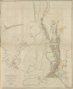
South Australia shewing the division into counties of the settled portions of the Province from the Surveys of Captn. Frome Rl. Engrs. Survr. Genl. of the Colony 1842. / John Arrowsmith. Scale [ca. 1:950 000 at 34° S]. London, Pubd.10th July 1843 by John Arrowsmith, 10 Soho Square. Clowes and Son Printers. -- 1 map : col. ; 68 x 57 cm. - Marginal series title: Papers relative to South Australia
Description
Shows
PRINTER:
Lower right beneath neat-line: Clowes and Son Printers.
MARGINAL SERIES TITLE:
Lower right outside neat-line between the imprint and the printer statement: Papers relative to South Australia.
COUNTIES:
FLINDERS, STANLEY, LIGHT, EYRE, GAWLER, ADELAIDE, STURT, HINDMARSH and RUSSELL
EXPLORERS' ROUTES:
[Edward John] Eyre's tracks of 1839 and 1840 are shown and Captain [Edward Charles] Frome's tracks of 1842. [Thomas] Burr's track dated 1840 also shown. He was Deputy Surveyor-General in the South Australian Survey Department
REFERENCE
F 3618 Great Britain and Ireland-Parliament-South Australia
Papers relative to South Australia. Presented to both Houses of Parliament by Command of Her Majesty. London: Printed by William Clowes and Sons, Stamford Street. For Her Majesty's Stationery Office. 1843.
Not in Tooley
NOTES:
Shows the area south of 31°30'S and from the Eyre Peninsula eastwards to the Coorong. Relief shown by 'hairy caterpillar' hachuring. Nine counties are shown.
This 1843/2 state has been printed by Parliament for insertion into one of its papers on South Australia.
Changes AND ADDITIONS
PRINTER:
Lower right beneath neat-line: Clowes and Son Printers.
MARGINAL SERIES TITLE:
Lower right outside neat-line between the imprint and the printer statement: Papers relative to South Australia.
NOTES
This map occurs in :
Papers relative to South Australia. Presented to both Houses of Parliament by Command of her Majesty. [505] London: Printed by William Clowes and Sons, Stamford Street. For Her Majesty's Stationery Office, 1843. which is bound with other titles in the Rare Books copy in The State Library of New South Wales. See below
Return to an address of the Honourable The House of Commons, dated 14 April 1842, for : copies of papers and despatches relating to New Zealand…
Map f. p. 332 in v. 43 (1842-43) NSL RB/DQ325.342/46 Rare Books. Spine title: Parliamentary documents (Great Britain and Ireland)
Other Locations
Great Britain. Parliament. House of Commons. Sessional Papers printed by order of the House of Commons … 1843. Map f. p. 332, v. XXXII, 1843. [505]
Great Britain. Parliament. House of Lords. Papers relative to South Australia. Sessional Papers printed by order of the House of Lords … 1843. Accounts and papers v. V. 1843. Map f. p. 332. UniM Bund SPC/BX f 328.41 GREA v. 5, 1843
Key Dates
- 1836 - 1843
- Situation date
- 10 July 1843
- Map Publication Date
Related entries
Timeline
South Australia shewing the division into counties of the settled portions of the Province, 1843/1
South Australia shewing the division into counties of the settled portions of the Province, 1843/2
South Australia shewing the division into counties of the settled portions of the Province, 1846/1
South Australia shewing the division into counties of the settled portions of the Province, 1858/1
Institutional and Other Holdings
Dixson Map Collection, State Library of New South Wales
- Papers relative to South Australia, Q84/76; Dixson Map Collection, State Library of New South Wales. Details
Mitchell Library, State Library of New South Wales
- Papers relative to South Australia, DSM/Q993/G; Mitchell Library, State Library of New South Wales. Details
Royal Geographical Society
- South Australia shewing the division into Counties... from the Surveys of Capt. Frome, 1843, mr Australia S/D.61; Royal Geographical Society. Details
State Library of New South Wales
- Papers relative to South Australia, RB/DQ325.342/46 v. 43 (1842-3); State Library of New South Wales. Details
State Library of South Australia
- South Australia shewing the division into counties of the settled portions of the province [cartographic material] : from the survey of Captn. Frome, Rl. Engrs., Survr. Genl. of the Colony, 1842 / John Arrowsmith, 10 Soho Square, 1843, C 994; State Library of South Australia. Details
State Library of Victoria, Maps Collection
- South Australia shewing the division into counties of the settled portions of the province [cartographic material] / from the surveys of Captn. Frome, Rl. Engrs., Survr. Genl. of the Colony, 1842 / John Arrowsmith, 10 Soho Square., MAPS 830.65 A 1842; State Library of Victoria, Maps Collection. Details
State Library of Victoria, Rare Books
- Papers relative to South Australia., 354.942 G79; State Library of Victoria, Rare Books. Details
Published resources
Books
Images
- Title
- South Australia shewing the division into counties of the settled portions of the Province, 1843/2
- Type
- Map
- Repository
- Mitchell Library, State Library of New South Wales
Dorothy F. Prescott
Created: 10 September 2010, Last modified: 27 March 2013