
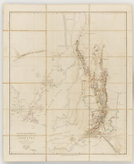
Map Summary South Australia shewing the division into counties of the settled portions of the Province, from the surveys of Captn. Frome, RL. Engrs., Survr. Genl. Of the Colony, 1842
This is the last map title which Arrowsmith included in his atlas which concerned South Australia. It replaced the previously published The Maritime Portion of South Australia and is a more focussed production, extending from 135 to 140 degrees of longitude east and from latitude 36 degrees to 31degrees south.
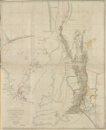
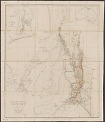
The map appears to have been first produced from 10 Soho Square in early 1843 and shows both John Eyre's (G. Dutton, 1966) tracks of 1838 and 1840, Thomas Burr's track of 1840 and Captain Edward Charles Frome's (Newland, 1966) tracks of September 1842. It was quickly utilised by a Parliamentary Committee that same year and included in Papers relative to South Australia (1843) and can be found in both Commons and Lords publications. It then appeared almost three years later refashioned to show the newly discovered mineral localities mainly in the hinterland and to the south of Adelaide. In this later state the title has been amended, two inset maps have been added in the top right and left of the map. The first is an inset of Australia showing the position of South Australia and the second is a plan of Port Adelaide. The latter shows proposed building allotments and proposed road south. This map was used in Dutton's South Australia and its mines (F. Dutton, 1843 & G. Dutton, 1966) issued in March 1846.
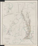
However there is a considerable lapse of time before this map actually appears in Arrowsmith's London Atlas, 1858 being the earliest date found. It is hard to say why this occurred. Arrowsmith was still using his The Maritime portion of South Australia as the principal map of the Colony although it was never updated after 1840.
Related entries
Published resources
Books
- Papers relative to South Australia, Printed by William Clowes for H.M.S.O, London, 1843. Details
- Dutton, Francis, South Australia and its mines : with an historical sketch of the colony, under its several administrations, to the period of Captain Grey's departure, T. and W. Boone, London, 1846. Details
Book Sections
- Dutton, Geoffrey, 'Dutton, Francis Stacker (1818-1877)', in Australian Dictionary of Biography, vol. 1, Melbourne University Press, Melbourne, 1966. http://adb.anu.edu.au/biography/dutton-francis-stacker-2241. Details
- Dutton, Geoffrey, 'Eyre, Edward John (1815-1901)', in Australian Dictionary of Biography, vol. 1, Melbourne University Press, Melbourne, 1966. http://adb.anu.edu.au/biography/eyre-edward-john-2032. Details
- Newland, B. C., 'Frome, Edward Charles (1802-1890)', in Australian Dictionary of Biography, vol. 1, Melbourne University Press, Melbourne, 1966. http://adb.anu.edu.au/biography/frome-edward-charles-2070. Details
Images
- Title
- South Australia shewing the division into counties of the settled portions of the Province, 1843/1
- Type
- Map
- Repository
- Dixson Map Collection, State Library of New South Wales
- Title
- South Australia shewing the division into counties of the settled portions of the Province, 1843/2
- Type
- Map
- Repository
- Mitchell Library, State Library of New South Wales
- Title
- South Australia shewing the division into counties of the settled portions of the Province, 1846/1
- Type
- Map
- Repository
- National Library of Australia Map Collection
- Title
- South Australia shewing the division into counties of the settled portions of the Province, 1858/1
- Type
- Map
- Repository
- National Library of Australia Map Collection
Dorothy F. Prescott
Created: 10 September 2010, Last modified: 3 July 2012