
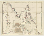
Map Summary A New Map of South Australia
This title appears to be the prototype of Arrowsmith's The Maritime Portion of South Australia. It was released for sale by Joseph Cross in May 1838 in an unfinished state lacking both title and creator statements. The map was cut and mounted on linen to fold into a map case. The title statement is sourced from the label on the map case. Arrowsmith's imprint appears below the map with his address being shown as '35 Essex Street, Strand'.
Arrowsmith's sources for the coastline of this map are charts South Coast Sheet III and South Coast Sheet IV in Matthew Flinders' Atlas to his A Voyage to Terra Australis published by G. and W. Nicol in 1814 (Flinders, 1814, Plates IV and V1 and v.1, pp. 200-201). The locations of the French names on the south east coast of South Australia have been adjusted by Arrowsmith from later material published by the French that was not available to Flinders at the time he drew his chart (Freycinet, 1812, Plates 10, 13, 14 and 15).
Matthew Flinders considered that the eastern limit of the French discoveries ended at their Cape Buffon shown on Arrowsmith's map as (C. Buffon of Baudin) West C. Banks. In his journal of the Voyage to Terra Australis Flinders explains that a portion of this coast north of Cape Buffon appeared on James Grant's chart published in his book A Voyage in the Lady Nelson to New South Wales, London in 1803 (Grant, 1803). He berates Peron for ignoring prior discoveries and applying French names to this coast and he Flinders uses the names given by Grant i.e. Cape Banks and Cape Northumberland.
Arrowsmith also used material from Freycinet's Voyage de découvertes aux Terres Australe. Partie Navigation et géographie. Atlas. Paris, 1812, of Isle Decrès (Kangaroo Island) for detail of the south coast of the island.
Discoveries in Nepean Bay, Rosetta Harbour, Rapid Bay and other names appearing on the east coast of the Gulf of St. Vincent, Port Adelaide, the city of Adelaide emanate from Colonel William Light's, Surveyor General of South Australia, explorations.
The course of the Murray is shown from Arrowsmith's mapping of Charles Sturt's voyage down the Murray to its mouth in 1832 and the River Glenelg from the explorations by Major Mitchell of Australia Felix in 1836.
Related entries
Published resources
Books
- Flinders, Matthew, A voyage to Terra Australis : undertaken for the purpose of completing the discovery of that vast country, and prosecuted in the years 1801, 1802, and 1803, in His Majesty's ship the Investigator. Atlas, G. and W. Nicol, London, 1814. Details
- Freycinet, Louis, Voyage de découvertes aux Terres Australes exécuté ... sur les corvettes le Géographe, le Naturaliste et la goëllette le Casuarina, pendant les années 1800, 1801, 1802, 1803, & 1804 ... Partie navigation et géographie., Paris, 1812. Details
- Grant, James, The narrative of a voyage of discovery, performed in His Majesty's vessel the Lady Nelson, of sixty tons burthen, with sliding keels, in the years 1800, 1801 and 1802, to New South Wales, T. Egerton, London, 1803. Details
Images
Dorothy F. Prescott
Created: 17 February 2011, Last modified: 3 July 2012