
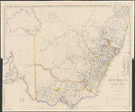
Map State The South Eastern Portion of Australia, 1853/1
The South Eastern Portion of Australia: compiled from the Colonial surveys and from details furnished by exploratory expeditions by John Arrowsmith. [Pl.] 35.
Scale 1:2 660 000. S 26° 30'--S 38° 30'/E 136° 30'--E 153° 40'. London, Pubd. 2nd. Jany. 1853 by John Arrowsmith, 10 Soho Square.
1 map : col. ; 51.5 x 62.0 cm.
Insets: Top left. [Australia]. -- Table below title: Route of travellers into the interior. -- Counties.
Description
Shows
PLATE NO:
35
IMPRINT:
Date in imprint now reads 2nd. Jany. 1853.
NOTE:
A three line note detailing dimensions and symbol for the Australian Agricultural Company's land holdings is placed above the list of Counties.
REFERENCE:
Gold fields in New South Wales is shown top left. This has been as amended to show gold found to the beginning of 1853.
INSET MAP:
Untitled map of Australia
COLONIES:
NEW SOUTH WALES, SOUTH AUSTRALIA, VICTORIA
BOUNDARIES:
New South Wales / South Australia / Victoria
REGIONS:
AUSTRALIA FELIX, NEW ENGLAND
PASTORAL DISTRICTS:
DARLING DOWNS, CLARENCE, MCLEAY, GWYDIR, LIVERPOOL PLAINS, NEW ENGLAND, BLIGH, WELLINGTON, LR. DARLING, LACHLAN, MURRAY, MURRUMBIDGEE, MONEROO, GIPPSLAND, WESTERN PORT, PORTLAND BAY and WIMMERA
TABLE: COUNTIES
Counties in New Sth Wales: Lists sixty eight counties in New South Wales in a numbered table.
TABLE: COUNTIES
Counties in Port Phillip lists 24 counties.
TABLE: EXPLORERS' ROUTES
Routes of travellers into the interior.
Lists with area traversed the journeys of [John] Oxley in 1817 and 1818; [Hamilton] Hume 1824; Allan Cunningham in 1825, 1827, 1828-9; [Charles] Sturt in 1828 and 1830; [Thomas Livingstone] Mitchell in 1832, 1835 and 1836; [Richard] Bourke in 1837; [Charles James] Tyers in 1839-40 and [Paul Edmond de] Strzelecki in 1840.
REFERENCE
Not in Tooley
NOTES
Extensive updating in New South Wales and Victoria showing many new places and gold finds.
Queensland
Many new names appear in the area marked Peel Plains in the 1848/1 state of this map and this whole area has been renamed the Darling Downs. New place names are Mt. Connel, Jimba, and the Cabulture R., Pine R., and Eden R. There is extensive development of the R. Condamine and the appearance of the R. Balonne.
New South Wales
In the 1838/1 state of the map knowledge of the River Darling has been progressed by two of Mitchell's expeditions, the first down the Darling from Bathurst in July 1835 and the second up the Darling from its junction with the Murray River in May 1836 'Major Mitchell's farthest N May 1836'. A noticeable development of the tributary system of the Darling is appearing. The Bogan R. is shown west of the Macquarie and Dixon's farthest in 1833 (Robert Dixon). Also shown here is a note Mr Cunningham killed by aboriginals hereabout. This refers to Richard Cunningham's death just west of the Bogan, which occurred about 15 April 1835] (Parsons, 1966, p.269)
The previous un-named section of the Great Dividing Range in northern NSW has been removed. The Moneroo or Brisbane Downs of the last state of the 'Discoveries' map is now shown as Moneroo Plains.
In the 1838/3 state of the map in the area north of the Apsley R. several place names appear, viz. Myall Cr., Dangar's, Cobb's, Russell's and the Big River.[Clarence]
The 1838/4 state shows for the first time the NEW ENGLAND area north of the Apsley River in New South Wales with sections of the Clarence River here named "Big River". The name New England was first used in 1836.
In the 1841/1 state of the map the mountain ranges are now delineated along with the major streams in NEW ENGLAND. The R. Severn appears flowing westwards into the Gwydir. The Clarence R. Flows from Ben Lomond to the coast at Shoal Bay. Ben Lomond and Mt. Mitchell named. The R. Apsley, R. McLeay and R. Nambucka are shown. The estuary of the Richmond R. And that of the R. Tweed appear.
The Mitta Mitta appears as a tributary of the Murray. From Mt. Ochtertyre the headwaters of the Murray River are redrawn showing a more easterly stream with this name. The stream emanates from the northern face of the Australian Alps in the vicinity of Mt Kosciusko.
In the 1848/1 state of the map in the north the coastal name of Peaked Hill or Wolanan is now shown as Whoming or Peaked Hill.
The supposed courses of many streams flowing into the upper reaches of the Darling are shown to the north of the river through an area marked Low level country. River courses flowing into the Darling or Karaula are extensively redrawn, particularly the Condamine R. system.
The region shown as NEW ENGLAND in the previous states is now shown as a pastoral district. A widespread drainage network appears.
In the south east of the Colony the map is rapidly being filled and the rivers Norarie, Dry, Brogo, Bembuca and Towamba appear. Many new coastal names appear between Bateman Bay and C. Howe. The coastline in this area has been redrawn.
Mt Kosciusko now has the alternative name of Mt. Wellington.
Along the R. Murray L. Victoria appears on the north bank close to the junction with the Darling, which has now been traversed and mapped. L. Cawndilla is shown west of the Darling near Mitchell's camp in 1836. Sturt's camp is also shown close by.
The name NEW SOUTH WALES appears for the first time in this 1852 state of the map between 29°--34°S. Grafton Range appears in the top margin. In the Reference the gold fields of Turon, Ophir, Louisa, Araluen and Abercrombie are shown.
In the 1853/1 state of the map another forty gold localities shown in NSW along the tributaries of the Shoalhaven, the Macquarie, Lachlan, Murrumbidgee, Molonglo, Eucumbene, Moruya and Snowy rivers.
Another supposed branch of the Darling appears above the name Darling or Karaula R. The R. Barwon named almost at its junction with the Castlereagh R. Colbaggie shown as a tributary of the Macquarie. Dubbo was previously located at the junction but now has been relocated further upstream the Macquarie.
Development of the tributary system of the Murrumbidgee occurs east of Wagga Wagga on the north bank and similarly for the Lachlan R. on the south bank.
On the south coast new coastal names appear, Turos, Wagonga, Burmague, Dry R. (Thubba) Mogareka and Murrimbulla
New South Wales/Victoria
In this 1844 (1842) state of the map in the south east the large triangular empty portion of the map behind Cape Howe now carries evidence of Ben Boyd's pastoral activities with descriptions such as Open forest, rich pasture in the vallies and other comments on the rock types, trap granite and limestone throughout this country. Vegetation is noted as Mountain ranges timbered with stringybark, gum, ironbark &c. The predominant features are the Wanderer's Range and the river systems of the Snowy R. And the Delegate R., McGlauhlan R. And the Woolwye R. Flowing from the Phelps and Guy ranges to the coast. At Twofold Bay Boyd appears and above it Eden and the tracks of Ben Boyd through this area are shown labelled 1843. The feature previously named as Peak in the hinterland of Cape Howe is now named Mt. Imlay or the Peak. Other new peaks are Mt. Brierly, Mt Cooper and Mt. Jenabroda. On the coast Pambula R. And Toallo Pt. Appear above Eden. Between Ram Head and Cape Howe the coast is annotated Narrow strip of grassy land. The whole area just described is named Boyd's Country
Victoria
In the 1838/1 state of the map there is a steadily growing knowledge of the westward flowing river systems emanating from the Australian Alps., viz. the Goulburn, Murray (supposed course), Ovens, Currojalinga or Swampy River, the R. Bayungun and several as yet un-named streams. The supposed source of the R. Murray is now shown as Lake Omio hereabouts on the eastern flank of the Australian Alps. Mitchell's AUSTRALIA FELIX is shown but only some of the details of his expedition are recorded.
In the 1838/2 state of the map Hume's route from the Murrumbidgee to Port Phillip is shown but in much greater detail than the version shown on the last state of the 'Discoveries' map. All the associated topographical information appears including the naming of the Murray River in its upper reaches as R. Murray or Hume. The font size and weight used is significant, indicating lesser importance for the second name. Additional river names are the King R., the Hovell, Goulburn or Bayungun R. and the R. Murray (Millewa).
The note above the junction of the Murray and Darling Rivers has been amended to read Major Mitchell's farthest N 2 June 1836.
In the 1841/1 state of the map many easterly flowing streams are named in the Gippsland area flowing to the coast, viz. the Thomson, Riley, McArthur, Perry, Dunlop, Barney, Maconochie and Latrobe. Mt. Kosciusko and other peaks in the Australian Alps are given with their heights. L. Omeo shown at height 3700 feet. Stzrelecki's route then follows the Thomson R. to L. King, it then proceeds west to Western Port, skirting the north shore to Jamison St., Donald, McCrae and Melbourne. The hinterland of Western Port appears. French Is. Is named and the settlements of Anderson and Berry.
In the vicinity of Melbourne the Yarra Yarra, Darebin Cr., Merri Merri Cr. and the Marriburnong are shown. Further west the country between the Pyrenees and the coast now has several rivers shown with native names, L. Carangamite and Tyers' track from Melbourne to the Glenelg. Polloc Plains appears in this area previously shown as open downs on the earlier state of the map. Tyers' return track in 1840 skirts the southern end of the Grampians south of Mitchell's track and north of Tyers' outbound track.
Between Cape Nelson and Cape Otway the coastline is drawn as uncertain.
In the 1848/1 state of the map the Jenoa R. And Mallagutta are shown. The Dunlop R. is now named Dunlop or Providence R. The river shown in the previous state as the Barney now carries the name Avon while to the west of this river the McAlister or Barney R. And the Maconochie R. are now shown as tributaries of the Latrobe R. Lakes Reeve and Wellington appear. The coast line between L. King and Westernport has been redrawn with many new place names in south Gippsland. In the hinterland of Westernport the Gt. Swamp is named. The upper reaches of the Yarra appear as do streams flowing north such as the Acheron, Rubicon, Big Cr., Goulburn, Howqua and Devil's R.
The R. Murray is now mapped from its source to its mouth, the southern tributaries being shown with authority while the northern tributaries are shown in very weak line work. Deniliquin and Albury are the only places mapped on the north bank. The Hovell, Goulburn or Bayungun R. is now named the R. Goulburn.
New place names and some small streams appear right around the coast west of Melbourne In the Wimmera district new rivers are the Wimmera R., Avon Wr., Avoca R. and the R. Loddon or Yarrayne and Lakes Hindmarsh and Bael Bael.
The name VICTORIA is now shown in the 1852 state of the map in the area previously known as the Port Phillip District. The table of counties still carries the heading Counties in Port Phillip.
Ballarat and Alexander goldfields listed in the Reference.
The Gippsland rivers are now named from east to west: Snowy R., Thomson R., Riley R., McArthur R., Perry R., Dunlop R., Avon R., McAlister or Barry, Maconochie R., La Trobe R.
In the 1853 state of the map in the WIMMERA north of Mt. Arapiles, new place names are Boughton, Yanaka, Yanak, Royco. On the Wimmera R., Antwerp, Ellerman Brs., Horsham and Glenorchy appear and further east, Navarre Inn, Carisbrook, and Castlemaine. Mt. Byng or Alexander in the previous state now shown as Mt. Alexander.
Gold occurs at Mt. Freeth, Daisy Hill, Buninyong, and Mt. Greenock northwest of Melbourne, while an occurrence is also shown at Nillumbik on the Yarra Yarra R. north east of Melbourne and in the Beechworth area.
New coastal names are from east to west Sydenham Inlet, Ewing's Marsh, L. Tyers, and Entrance. L. King moved west and its former position now shown as L. Bunga. L. Reeve removed but Reeve Lag. Appears west of L. Wellington. The Gippsland rivers have name changes, from east to west they are shown as, Snowy R., Tambo R., Nicholson R., Mitchell R., Perry, Avon R., McAlister R., and La Trobe R. The Barney Plains have been removed.
South Australia
In the 1838/1 state of the map in South Australia the eastern coast of the Gulf of St. Vincent shows many new names including Adelaide. Mt Lofty reappears. There are more names on Kangaroo Island. The extensive notes along the lower Murray River have been removed and similarly along the river Murrumbidgee. A three line note on Charles Sturt's navigation down the Murray appears at the junction with the Murrumbidgee.
The first updating of South Australia occurs in the 1848/1 state of the map. Lake Alexandrina of the previous state is now redrawn and renamed L. Victoria and the southern extension of that lake now named L. Albert. The mouth of the Murray R. and coastline is redrawn. Goolwa, Pt. Pullen and Hindmarsh I. appear. The Coorong is named and Bonney's Well. Coastal lagoons are shown from Cape Bernouilli to C. Northumberland. Many new coastal place names appear in this section of the coast.
The R. Murray from Elbow bend realigned further west. Julia Is., Selente Pt., Moorundie and Bonney's Crossing are shown on the lower Murray.
In the 1853/1 state of the map a proposed route from Adelaide to Mt Alexander appears and below this the present route. On this route Canaulia, Colonlia and Tattiara appear.
The Field R. on the east coast of the Gulf of St. Vincent now has the Onkaparinga R. as a tributary. Gold is shown here and at Echunga
Changes AND ADDITIONS
IMPRINT:
Date in imprint now reads 2nd. Jany. 1853.
TABLE:
The table of counties now shows 68 in N.S.W.
REFERENCE:
The following added: Also are marked the localities where gold has been discovered to the beginning of 1853.
NOTES
Extensive updating in New South Wales and Victoria showing many new places and gold finds.
New South Wales
Forty gold localities shown in NSW along the tributaries of the Shoalhaven, the Macquarie, Lachlan, Murrumbidgee, Molonglo, Eucumbene, Moruya and Snowy rivers.
Another supposed branch of the Darling appears above the name Darling or Karaula R. The R. Barwon named almost at its junction with the Castlereagh R. Colbaggie shown as a tributary of the Macquarie. Dubbo was previously located at the junction but now has been relocated further upstream the Macquarie.
Development of the tributary system of the Murrumbidgee occurs east of Wagga Wagga on the north bank and similarly for the Lachlan R. on the south bank.
On the south coast new coastal names appear, Turos, Wagonga, Burmague, Dry R. (Thubba) Mogareka and Murrimbulla
Victoria
In the WIMMERA north of Mt. Arapiles, new place names are Boughton, Yanaka, Yanak, Royco. On the Wimmera R., Antwerp, Ellerman Brs., Horsham and Glenorchy appear and further east, Navarre Inn, Carisbrook, and Castlemaine. Mt. Byng or Alexander in the previous state now shown as Mt. Alexander.
Gold occurs at Mt. Freeth, Daisy Hill, Buninyong, and Mt. Greenock northwest of Melbourne, while an occurrence is also shown at Nillumbik on the Yarra Yarra R. north east of Melbourne and in the Beechworth area.
New coastal names are from east to west Sydenham Inlet, Ewing's Marsh, L. Tyers, and Entrance. L. King moved west and its former position now shown as L. Bunga. L. Reeve removed but Reeve Lag. Appears west of L. Wellington. The Gippsland rivers have name changes, from east to west they are shown as, Snowy R., Tambo R., Nicholson R., Mitchell R., Perry, Avon R., McAlister R., and La Trobe R. The Barney Plains have been removed.
South Australia
The proposed route from Adelaide to Mt Alexander appears and below this the present route. On this route Canaulia, Colonlia and Tattiara appear.
The Field R. on the east coast of the Gulf of St. Vincent now has the Onkaparinga R. as a tributary. Gold is shown here and at Echunga
Key Dates
- 1817 - 1853
- Situation date
- 2 January 1853
- Map Publication Date
Related entries
Timeline
The South Eastern Portion of Australia, 1838/1
The South Eastern Portion of Australia, 1838/2
The South Eastern Portion of Australia, 1838/3
The South Eastern Portion of Australia, 1838/4
The South Eastern Portion of Australia, 1838/5 (1857)
The South Eastern Portion of Australia, 1841/1
The South Eastern Portion of Australia, 1842/1
The South Eastern Portion of Australia, 1844/1 (1842/2)
The South Eastern Portion of Australia, 1848/1
The South Eastern Portion of Australia, 1852/1
The South Eastern Portion of Australia, 1853/1
The South Eastern Portion of Australia, 1860/1 (1858/1)
Institutional and Other Holdings
British Library Map Library
- The South Eastern portion of Australia, compiled from the Colonial surveys by John Arrowsmith [Scale,] English miles 100[= 60 mm], 1853, Maps 90100.(26.); British Library Map Library. Details
Dixson Map Collection, State Library of New South Wales
- The South Eastern Portion of Australia [cartographic material] / compiled from the colonial surveys, and from details furnished by exploratory expeditions, by John Arrowsmith., 1853, 85/314; Dixson Map Collection, State Library of New South Wales. Details
Library of Congress, Geography and Map Division
- The London Atlas of Universal Geography, 1842, G1019 .A8 1842c fol. Copy 1; Library of Congress, Geography and Map Division. Details
Mitchell Map Collection, State Library of New South Wales
- The South Eastern Portion of Australia [cartographic material] / compiled from the colonial surveys, and from details furnished by exploratory expeditions, by John Arrowsmith., 1853, Z/M2 806/1853/2; Mitchell Map Collection, State Library of New South Wales. Details
- The South Eastern Portion of Australia [cartographic material] / compiled from the colonial surveys, and from details furnished by exploratory expeditions, by John Arrowsmith., 1853, Z/M2 806/1853/1; Mitchell Map Collection, State Library of New South Wales. Details
National Library of Australia Map Collection
- The South Eastern Portion of Australia [cartographic material] / compiled from the colonial surveys, and from details furnished by exploratory expeditions, by John Arrowsmith, 1853, MAP RM 925A; National Library of Australia Map Collection. Details
Sir George Grey Special Collections, Auckland Libraries
- The London Atlas of Universal Geography : exhibiting the physical & political divisions of the various countries of the world, constructed from original materials [cartographic material] / John Arrowsmith., 912 A77; Sir George Grey Special Collections, Auckland Libraries. Details
State Library of Queensland
- The South Eastern Portion of Australia compiled from the colonial surveys, and from details furnished by exploratory expeditions, 1853, M 804 1853 02682 F; State Library of Queensland. Details
State Library of Victoria, Maps Collection
- The South Eastern Portion of Australia [cartographic material] / compiled from the colonial surveys, and from details furnished by exploratory expeditions, by John Arrowsmith., 2 January 1853, MAPS 805.5 A 1853 ARROWSMITH; State Library of Victoria, Maps Collection. Details
Taylorian Library, Oxford
- The London Atlas of Universal Geography, : exhibiting the physical & political divisions of the various countries of the world, constructed from original materials. / By ... John Arrowsmith, 1842, REP.X.12; Taylorian Library, Oxford. Details
University of Texas Arlington Library
- The London Atlas of Universal Geography : exhibiting the physical & political divisions of the various countries of the world : constructed from original materials / John Arrowsmith., 1842, G 1019 .A77 1842; University of Texas Arlington Library. Details
Published resources
Books
- Tooley, Ronald Vere, The mapping of Australia and Antarctica, Holland Press, London, 1985, 649 pp. Details
Book Sections
- Parsons, Vivienne, 'Cunningham, Richard (1793 - 1835?)', in Australian Dictionary of Biography, vol. 1, Melbourne University Press, Melbourne, 1966, pp. 268-269. http://adb.anu.edu.au/biography/cunningham-richard-1943. Details
Images
- Title
- The South Eastern Portion of Australia, 1853/1
- Type
- Map
- Repository
- National Library of Australia Map Collection
Dorothy F. Prescott
Created: 13 September 2010, Last modified: 22 April 2015