
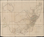
Map State The South Eastern Portion of Australia, 1844/1 (1842/2)
The South Eastern Portion of Australia: compiled from the Colonial surveys and from details furnished by exploratory expeditions by John Arrowsmith. [Pl.] 35.
Scale 1:2 660 000. S 26° 30'--S 38° 30'/E 136° 30'--E 153° 40'. London, Pubd. 2nd June 1842 by John Arrowsmith, 10 Soho Square.
1 map : col. ; 51.5 x 62.0 cm.
Insets: Top left. [Australia]. -- Table below title: Route of travellers into the interior. -- Counties.
Description
Shows
PLATE NO.
35
IMPRINT:
Remains unchanged as 2nd June 1842. However the map is much later than the imprint date suggests, 1844 being suggested as the more accurate time period.
INSET MAP:
Untitled map of Australia
COLONIES:
NEW SOUTH WALES, SOUTH AUSTRALIA
BOUNDARIES:
New South Wales / South Australia
REGIONS:
AUSTRALIA FELIX, NEW ENGLAND
TABLE: COUNTIES
Lists the nineteen counties of New South Wales in a numbered table
TABLE: EXPLORERS' ROUTES
Routes of travellers into the interior.
Lists with area traversed the journeys of [John] Oxley in 1817 and 1818; [Hamilton] Hume 1824; Allan Cunningham in 1825, 1827, 1828-9; [Charles] Sturt in 1828 and 1830; [Thomas Livingstone] Mitchell in 1832, 1835 and 1836; [Richard] Bourke in 1837; [Charles James] Tyers in 1839-40 and [Paul Edmond de] Strzelecki in 1840.
REFERENCE
Not in Tooley
NOTES
New South Wales
In the 1838/1 state of the map knowledge of the River Darling has been progressed by two of Mitchell's expeditions, the first down the Darling from Bathurst in July 1835 and the second up the Darling from its junction with the Murray River in May 1836 'Major Mitchell's farthest N May 1836'. A noticeable development of the tributary system of the Darling is appearing. The Bogan R. is shown west of the Macquarie and Dixon's farthest in 1833 (Robert Dixon). Also shown here is a note Mr Cunningham killed by aboriginals hereabout. This refers to Richard Cunningham's death just west of the Bogan, which occurred about 15 April 1835] (Parsons, 1966, p.269)
The previous un-named section of the Great Dividing Range in northern NSW has been removed. The Moneroo or Brisbane Downs of the last state of the 'Discoveries' map is now shown as Moneroo Plains.
In the 1838/3 state of the map in the area north of the Apsley R. several place names appear, viz. Myall Cr., Dangar's, Cobb's, Russell's and the Big River.[Clarence]
The 1838/4 state shows for the first time the NEW ENGLAND area north of the Apsley River in New South Wales with sections of the Clarence River here named "Big River". The name New England was first used in 1836.
In the 1841/1 state of the map the mountain ranges are now delineated along with the major streams in NEW ENGLAND. The R. Severn appears flowing westwards into the Gwydir. The Clarence R. flows from Ben Lomond to the coast at Shoal Bay. Ben Lomond and Mt. Mitchell named. The R. Apsley, R. McLeay and R. Nambucka are shown. The estuary of the Richmond R. and that of the R. Tweed appear.
The Mitta Mitta appears as a tributary of the Murray. From Mt. Ochtertyre the headwaters of the Murray River are redrawn showing a more easterly stream with this name. The stream emanates from the northern face of the Australian Alps in the vicinity of Mt Kosciusko.
New South Wales/Victoria
In this 1844 (1842) state of the map in the south east the large triangular empty portion of the map behind Cape Howe now carries evidence of Ben Boyd's pastoral activities with descriptions such as Open forest, rich pasture in the vallies and other comments on the rock types, trap granite and limestone throughout this country. Vegetation is noted as Mountain ranges timbered with stringybark, gum, ironbark &c. The predominant features are the Wanderer's Range and the river systems of the Snowy R. and the Delegate R., McGlauhlan R. and the Woolwye R. flowing from the Phelps and Guy ranges to the coast. At Twofold Bay Boyd appears and above it Eden and the tracks of Ben Boyd through this area are shown labelled 1843. The feature previously named as Peak in the hinterland of Cape Howe is now named Mt. Imlay or the Peak. Other new peaks are Mt. Brierly, Mt Cooper and Mt. Jenabroda. On the coast Pambula R. and Toallo Pt. appear above Eden. Between Ram Head and Cape Howe the coast is annotated Narrow strip of grassy land. The whole area just described is named Boyd's Country
Victoria
In the 1838/1 state of the map there is a steadily growing knowledge of the westward flowing river systems emanating from the Australian Alps., viz. the Goulburn, Murray (supposed course), Ovens, Currojalinga or Swampy River, the R. Bayungun and several as yet un-named streams. The supposed source of the R. Murray is now shown as Lake Omio hereabouts on the eastern flank of the Australian Alps. Mitchell's AUSTRALIA FELIX is shown but only some of the details of his expedition are recorded.
In the 1838/2 state of the map Hume's route from the Murrumbidgee to Port Phillip is shown but in much greater detail than the version shown on the last state of the 'Discoveries' map. All the associated topographical information appears including the naming of the Murray River in its upper reaches as R. Murray or Hume. The font size and weight used is significant, indicating lesser importance for the second name. Additional river names are the King R., the Hovell, Goulburn or Bayungun R. and the R. Murray (Millewa).
The note above the junction of the Murray and Darling Rivers has been amended to read Major Mitchell's farthest N 2 June 1836.
In the 1841/1 state of the map many easterly flowing streams are named in the Gippsland area flowing to the coast, viz. the Thomson, Riley, McArthur, Perry, Dunlop, Barney, Maconochie and Latrobe. Mt. Kosciusko and other peaks in the Australian Alps are given with their heights. L. Omeo shown at height 3700 feet. Stzrelecki's route then follows the Thomson R. to L. King, it then proceeds west to Western Port, skirting the north shore to Jamison St., Donald, McCrae and Melbourne. The hinterland of Western Port appears. French Is. is named and the settlements of Anderson and Berry.
In the vicinity of Melbourne the Yarra Yarra, Darebin Cr., Merri Merri Cr. and the Marriburnong are shown. Further west the country between the Pyrenees and the coast now has several rivers shown with native names, L. Carangamite and Tyers' track from Melbourne to the Glenelg. Polloc Plains appears in this area previously shown as open downs on the earlier state of the map. Tyers' return track in 1840 skirts the southern end of the Grampians south of Mitchell's track and north of Tyers' outbound track.
Between Cape Nelson and Cape Otway the coastline is drawn as uncertain.
South Australia
In the 1838/1 state of the map in South Australia the eastern coast of the Gulf of St. Vincent shows many new names including Adelaide. Mt Lofty reappears. There are more names on Kangaroo Island. The extensive notes along the lower Murray River have been removed and similarly along the river Murrumbidgee. A three line note on Charles Sturt's navigation down the Murray appears at the junction with the Murrumbidgee.
No further changes.
Changes AND ADDITIONS
IMPRINT:
Remains unchanged as 2nd June 1842. However the map is much later than the imprint date suggests, 1844 being suggested as the more accurate time period.
NOTES
New South Wales/Victoria
In the south east the large triangular empty portion of the map behind Cape Howe now carries evidence of Ben Boyd's pastoral activities with descriptions such as Open forest, rich pasture in the vallies and other comments on the rock types, trap granite and limestone throughout this country. Vegetation is noted as Mountain ranges timbered with stringybark, gum, ironbark &c. The predominant features are the Wanderer's Range and the river systems of the Snowy R. and the Delegate R., McGlauhlan R. and the Woolwye R. flowing from the Phelps and Guy ranges to the coast. At Twofold Bay Boyd appears and above it Eden and the tracks of Ben Boyd through this area are shown labelled 1843. The feature previously named as Peak in the hinterland of Cape Howe is now named Mt. Imlay or the Peak. Other new peaks are Mt. Brierly, Mt Cooper and Mt. Jenabroda. On the coast Pambula R. and Toallo Pt. appear above Eden. Between Ram Head and Cape Howe the coast is annotated Narrow strip of grassy land. The whole area just described is named Boyd's Country.
Key Dates
- 1817 - 1844
- Situation date
- 2 June 1842
- Map Publication Date
Related entries
Timeline
The South Eastern Portion of Australia, 1838/1
The South Eastern Portion of Australia, 1838/2
The South Eastern Portion of Australia, 1838/3
The South Eastern Portion of Australia, 1838/4
The South Eastern Portion of Australia, 1838/5 (1857)
The South Eastern Portion of Australia, 1841/1
The South Eastern Portion of Australia, 1842/1
The South Eastern Portion of Australia, 1844/1 (1842/2)
The South Eastern Portion of Australia, 1848/1
The South Eastern Portion of Australia, 1852/1
The South Eastern Portion of Australia, 1853/1
The South Eastern Portion of Australia, 1860/1 (1858/1)
Institutional and Other Holdings
Cambridge University Library
- The London Atlas of Universal Geography : by his much obliged and humble servant John Arrowsmith., 1842, Atlas.2.84.13; Cambridge University Library. Details
- The London Atlas of Universal Geography : exhibiting the physical & political divisions of the various countries of the world, constructed from original materials., 1842, Atlas.2.84.9; Cambridge University Library. Details
Mitchell Map Collection, State Library of New South Wales
- The South Eastern Portion of Australia [cartographic material] / compiled from the colonial surveys, and from details furnished by exploratory expeditions, by John Arrowsmith., 1842, M3 806/1842/1; Mitchell Map Collection, State Library of New South Wales. Details
National Library of Australia Map Collection
- The South Eastern portion of Australia [cartographic material] / compiled from the colonial surveys and from details furnished by exploratory expeditions by John Arrowsmith, MAP RM 3010; National Library of Australia Map Collection. Details
State Library of South Australia
- The South Eastern Portion of Australia [cartographic material] / compiled from the colonial surveys, and from details furnished by exploratory expeditions, by John Arrowsmith, 1842, rbr 325022; State Library of South Australia. Details
State Library of Victoria, Maps Collection
- The South Eastern Portion of Australia [cartographic material] / compiled from the colonial surveys, and from details furnished by exploratory expeditions, by John Arrowsmith., 1842, MAPS 805.5 A 1842 ARROWSMITH; State Library of Victoria, Maps Collection. Details
The University of Melbourne Library, Special Collections
- The London atlas of universal geography : exhibiting the physical & political divisions of the various countries of the world, UniM Bail SpC/BX ef 912 A779; The University of Melbourne Library, Special Collections. Details
Published resources
Books
- Tooley, Ronald Vere, The mapping of Australia and Antarctica, Holland Press, London, 1985, 649 pp. Details
Book Sections
- Parsons, Vivienne, 'Cunningham, Richard (1793 - 1835?)', in Australian Dictionary of Biography, vol. 1, Melbourne University Press, Melbourne, 1966, pp. 268-269. http://adb.anu.edu.au/biography/cunningham-richard-1943. Details
Images
- Title
- The South Eastern Portion of Australia, 1844/1 (1842/2)
- Type
- Map
- Repository
- National Library of Australia Map Collection
Dorothy F. Prescott
Created: 13 September 2010, Last modified: 7 August 2012