
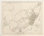
Map State The South Eastern Portion of Australia, 1838/3
The South Eastern Portion of Australia: compiled from the Colonial surveys and from details furnished by exploratory expeditions by John Arrowsmith. [Pl.] 35.
Scale 1:2 660 000. S 26° 30'--S 38° 30'/E 136° 30'--E 153° 40'. London, Pubd. 2d. Aug.1838 by John Arrowsmith, 10 Soho Square.
1 map : col. ; 51.5 x 62.0 cm.
Insets: Top left. [Australia]. -- Table below title: Route of travellers into the interior. -- Counties.
Description
Shows
IMPRINT:
The address now reads 10 Soho Square
PLATE NO:
35
NOTE:
A three line note detailing dimensions and symbol for the Australian Agricultural Company's land holdings is placed above the list of Counties.
INSET:
Untitled map of Australia.
COLONIES:
NEW SOUTH WALES, SOUTH AUSTRALIA
BOUNDARIES:
New South Wales/South Australia.
REGIONS:
AUSTRALIA FELIX
TABLE: COUNTIES
Lists the nineteen counties of New South Wales in a numbered table
TABLE: EXPLORERS' ROUTES
Routes of travellers into the interior.
Lists with area traversed the journeys of [John] Oxley in 1817 and 1818; [Hamilton] Hume 1824; Allan Cunningham in 1825, 1827, 1828-9; [Charles] Sturt in 1828 and 1830; [Thomas Livingstone] Mitchell in 1832, 1835 and 1836, and [Richard] Bourke in 1837.
REFERENCE
T 96
NOTES
New South Wales
In the 1838/1 state of the map knowledge of the River Darling has been progressed by two of Mitchell's expeditions, the first down the Darling from Bathurst in July 1835 and the second up the Darling from its junction with the Murray River in May 1836 'Major Mitchell's farthest N May 1836'. A noticeable development of the tributary system of the Darling is appearing. The Bogan R. is shown west of the Macquarie and Dixon's farthest in 1833 (Robert Dixon). Also shown here is a note Mr Cunningham killed by aboriginals hereabout. This refers to Richard Cunningham's death just west of the Bogan, which occurred about 15 April 1835] (Parsons, 1966, p.269)
The previous un-named section of the Great Dividing Range in northern NSW has been removed. The Moneroo or Brisbane Downs of the last state of the 'Discoveries' map is now shown as Moneroo Plains.
In this 1838/3 state in the area north of the Apsley R. several place names appear, viz. Myall Cr., Dangar's, Cobb's, Russell's and the Big River [Clarence].
Victoria
In the 1838/1 state of the map there is a steadily growing knowledge of the westward flowing river systems emanating from the Australian Alps., viz. the Goulburn, Murray (supposed course), Ovens, Currojalinga or Swampy River, the R. Bayungun and several as yet un-named streams. The supposed source of the R. Murray is now shown as Lake Omio hereabouts on the eastern flank of the Australian Alps. As stated at the beginning of this description, Mitchell's AUSTRALIA FELIX.
In the 1838/2 state of the map Hume's route from the Murrumbidgee to Port Phillip is shown but in much greater detail than the version shown on the last state of the 'Discoveries' map. All the associated topographical information appears including the naming of the Murray River in its upper reaches as R. Murray or Hume. The font size and weight used is significant, indicating lesser importance for the second name. Additional river names are the King R., the Hovell, Goulburn or Bayungun R. and the R. Murray (Millewa).
The note above the junction of the Murray and Darling Rivers has been amended to read Major Mitchell's farthest N 2 June 1836.
No further changes in this state of the map.
South Australia
In the 1838/1 state of the map in South Australia the eastern coast of the Gulf of St. Vincent shows many new names including Adelaide. Mt Lofty reappears. There are more names on Kangaroo Island. The extensive notes along the lower Murray River have been removed and similarly along the river Murrumbidgee. A three line note on Charles Sturt's navigation down the Murray appears at the junction with the Murrumbidgee.
No further changes in this state of the map.
Changes AND ADDITIONS
IMPRINT:
The imprint date is unchanged but the address now reads 10 Soho Square
NOTES
New South Wales
In the area north of the Apsley R. several place names appear, viz. Myall Cr., Dangar's, Cobb's, Russell's and the Big River [Clarence].
Key Dates
- 1817 - 1838
- Situation date
- 2 August 1838
- Map Publication Date
Related entries
Timeline
The South Eastern Portion of Australia, 1838/1
The South Eastern Portion of Australia, 1838/2
The South Eastern Portion of Australia, 1838/3
The South Eastern Portion of Australia, 1838/4
The South Eastern Portion of Australia, 1838/5 (1857)
The South Eastern Portion of Australia, 1841/1
The South Eastern Portion of Australia, 1842/1
The South Eastern Portion of Australia, 1844/1 (1842/2)
The South Eastern Portion of Australia, 1848/1
The South Eastern Portion of Australia, 1852/1
The South Eastern Portion of Australia, 1853/1
The South Eastern Portion of Australia, 1860/1 (1858/1)
Institutional and Other Holdings
State Library of Western Australia
- The London Atlas of Universal Geography, exhibiting the physical & political divisions of the various countries of the world, constructed from original materials [cartographic material] / John Arrowsmith., 1840, 1019 Rare Room 1; State Library of Western Australia. Details
The University of Melbourne Library, Eastern Resource Centre Map Collection
- The South Eastern Portion of Australia [cartographic material] / compiled from the colonial surveys, and from details furnished by exploratory expeditions by John Arrowsmith., 1838, UniM ERC MAPS MX 804.65 a 1838; The University of Melbourne Library, Eastern Resource Centre Map Collection. Details
Published resources
Books
- Tooley, Ronald Vere, The mapping of Australia and Antarctica, Holland Press, London, 1985, 649 pp. Details
Book Sections
- Parsons, Vivienne, 'Cunningham, Richard (1793 - 1835?)', in Australian Dictionary of Biography, vol. 1, Melbourne University Press, Melbourne, 1966, pp. 268-269. http://adb.anu.edu.au/biography/cunningham-richard-1943. Details
Images
- Title
- The south eastern portion of Australia, 1838/3
- Type
- Map
- Repository
- The University of Melbourne Library, Eastern Resource Centre Map Collection
Dorothy F. Prescott
Created: 13 September 2010, Last modified: 3 July 2012