
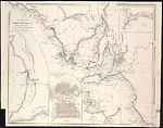
Map State Maritime Portion of South Australia, 1840/1
The maritime portion of South Australia, from Captn Flinders & from more recent surveys made by the Survr Genl of the Colonies by John Arrowsmith. -- Scale [ca. 1:1 350 000 at 36° S] (S 32°-S 38° 15'/ E 132°-E 141°). -- London, Published Feby. 5th 1840 … 10 Soho Square. -- 1 map : col. ; 51.0 x 63.5 cm.
INSETS:
Top right: Sketch of Encounter Bay by Colonel Light and B. T. Finniss Esqr. 1838. -- Lower right: Sketch of Nepean Bay and Kingscote Harbour. -- Centre bottom: The city of Adelaide with the acre allotments numbered and surveyed by Col. Light. -- At left: [Gulf of St. Vincent].
Description
TITLE:
The title has been changed to read: The maritime portion of South Australia, from Captn Flinders & from more recent surveys made by the Survr Genl of the Colonies by John Arrowsmith.
IMPRINT:
Now reads: Published Feby. 5th 1840 … 10 Soho Square.
PASTE OVER:
Some copies have a paste over with the name and address of G. Crutchley, map seller and publisher. [n. d.]
PLATE NO:
There is no plate number printed on these maps. Those which are recorded as having plate numbers shown beside them may have had this number added in ms. to either the recto or the verso of the sheet in the atlas in which they have been recorded.
MARGINAL NOTE:
Upper right margin: Torrens L. and Mr Eyre's route to the N of Mt Arden are placed too far S by about 11 miles.
REGIONS:
STURT LAND, BONNY LAND, EYRE LAND
NOTES:
The 1838/3 state of the map shows South Australia from 32° S southwards and includes both the western and eastern boundaries of the Colony. As the title suggests the information is mainly coastal in nature. The main map has three inset maps. They are, Sketch of Nepean Bay and Kingscote Harbour by Wm. Chesser, The city of Adelaide with acre allotments numbered, surveyed by Col. Light, and [Gulf of St. Vincent].
In the 1839/2 state of the map the INSET Gulf of St Vincent shows a number of new streams, namely, Ormsby R., Anstey R., R. Todd, R. Hallet and one un-named stream as north flowing tributaries of the Torrens River. Further south Brownhill R. and R. Sturt are shown.
Also in the 1839/2 state a new INSET map is inserted Sketch of Encounter Bay by Col. Light and B.T. Finniss Esqr. 1838. This plan shows Victor Harbour and Rosetta Harbour, a proposed town and allotments of land laid out for sale.
The 1839/3 state of the map has only a change of address and is otherwise unchanged.
The 1840/1 state of the map has been completely revised with a change of title which is now located at the top left of the map. Much new information appears. The Eyre Peninsula is shown as EYRE LAND with Eyre's track (unnamed) from the peninsula going westward along the coast towards Streaky Bay and on to Pt. Bell (32°S /133°'05'E) then north via the Gawler Range to Mt. Arden.
North of Spencer Gulf the Flinders Range and the tip of L. Torrens appear. New topographic features to the north-east of Yorke Peninsula include Crystal Brook, Rocky R., R. Broughton and Reedy Cr. East of these streams are parallel north/south trending ranges. There is much development north and east of Adelaide with many unnamed streams and ranges. This area has been named STURT LAND.
East of the Murray River the entire area reaching to the south coast is named BONNY LAND.
PRELIMINARY ISSUE:
A prototype was issued in May 1838 which appears to be a preliminary proof lacking the main title and the title to the inset of Adelaide which are present in the following states.
See A New Map of South Australia.
Changes AND ADDITIONS
TITLE:
The title has been moved to the top left hand side of the map and the wording changed to read: The Maritime portion of South Australia, from Captn Flinders & from more recent surveys made by the Survr. Genl. Of the Colonies by John Arrowsmith.
IMPRINT:
Now reads: Published Feby. 5th 1840 … 10 Soho Square.
PASTE OVER:
Some copies have a paste over with the name and address of G. Crutchley, map seller and publisher. [n. d.]
MARGINAL NOTE:
Added upper right
NOTES:
The map is extensively revised as the notes indicate, three regions also being named.
Key Dates
- 1802 - 1839
- Situation date
- 5 February 1840
- Map Publication Date
Related entries
Timeline
A New Map of South Australia (11 May 1838)
Maritime Portion of South Australia, 1838/2
Maritime Portion of South Australia, 1839/1
Maritime Portion of South Australia, 1839/2
Maritime Portion of South Australia, 1839/3
Maritime Portion of South Australia, 1840/1
Maritime Portion of South Australia, 1841/1
Maritime Portion of South Australia, 1841/2
Institutional and Other Holdings
British Library Map Library
- The London Atlas of Universal Geography ... by ... John Arrowsmith, 1842, Cartographic Items Maps 43.f.23.; British Library Map Library. Details
- The London Atlas of Universal Geography exhibiting the physical & political divisions of the various countries of the world, constructed from original materials., 1847, Maps 224.c.75.; British Library Map Library. Details
Cambridge University Library
- The London Atlas of Universal Geography : by his much obliged and humble servant John Arrowsmith., 1842, Atlas.2.84.13; Cambridge University Library. Details
Dixson Map Collection, State Library of New South Wales
- The Maritime Portion of South Australia [cartographic material] : from the surveys of Captn. Flinders & of Col. Light, Survr. Genl. / by John Arrowsmith., 84/389; Dixson Map Collection, State Library of New South Wales. Details
Library of Congress, Geography and Map Division
- The London Atlas of Universal Geography, 1842, G1019 .A8 1842c fol. Copy 1; Library of Congress, Geography and Map Division. Details
- The London Atlas of Universal Geography, 1842, G1019 .A8 1842b fol. Copy 1; Library of Congress, Geography and Map Division. Details
- The London Atlas of Universal Geography, exhibiting the physical & political divisions of the various countries of the world, constructed from original materials, G1019 .A8 1842 fol. Copy 1; Library of Congress, Geography and Map Division. Details
- The London Atlas of Universal Geography, exhibiting the physical & political divisions of the various countries of the world, constructed from original materials, 1840, G1019 .A8 1840 Vault fol. Copy 1; Library of Congress, Geography and Map Division. Details
Mitchell Map Collection, State Library of New South Wales
- The Maritime Portion of South Australia [cartographic material] : from Captn. Flinders & from more recent surveys made by the Survr. Genl. of the Colonies / by John Arrowsmith., 1840, ZMC 830/1840/1; Mitchell Map Collection, State Library of New South Wales. Details
National Library of Australia Map Collection
- The Maritime Portion of South Australia [cartographic material] : from Captn. Flinders & from more recent surveys made by the Survr. Genl. of the Colonies / by John Arrowsmith, 1840, MAP T 110; National Library of Australia Map Collection. Details
- The Maritime Portion of South Australia [cartographic material] : from Captn. Flinders & from more recent surveys made by the Survr. Genl. of the Colonies / by John Arrowsmith, 1840, MAP RM 1124; National Library of Australia Map Collection. Details
- The Maritime Portion of South Australia [cartographic material] : from Captn. Flinders & from more recent surveys made by the Survr. Genl. of the Colonies / by John Arrowsmith, MAP NK 2456/155; National Library of Australia Map Collection. Details
Queen's College, Oxford
- The London Atlas of Universal Geography, : exhibiting the physical & political divisions of the various countries of the world, constructed from original materials. / By ... John Arrowsmith, 1842, 14.G.1; Queen's College, Oxford. Details
State Library of South Australia
- The Maritime Portion of South Australia [cartographic material] : from Captn. Flinders & from more recent surveys made by the Survr. Genl. of the Colonies / by John Arrowsmith, 1840, C 934; State Library of South Australia. Details
State Library of Victoria, Maps Collection
- The Maritime Portion of South Australia [cartographic material] : from Captn. Flinders & from more recent surveys made by the Survr. Genl. of the Colonies / by John Arrowsmith., 5 February 1840, MAPS 830.65 A 1840 ARROWSMITH; State Library of Victoria, Maps Collection. Details
Taylorian Library, Oxford
- The London Atlas of Universal Geography, : exhibiting the physical & political divisions of the various countries of the world, constructed from original materials. / By ... John Arrowsmith, 1842, REP.X.12; Taylorian Library, Oxford. Details
University of Texas Arlington Library
- The London Atlas of Universal Geography : exhibiting the physical & political divisions of the various countries of the world : constructed from original materials / John Arrowsmith., 1842, G 1019 .A77 1842; University of Texas Arlington Library. Details
Published resources
Books
- Tooley, Ronald Vere, The mapping of Australia and Antarctica, Holland Press, London, 1985, 649 pp. Details
Images
- Title
- Maritime Portion of South Australia, 1840/1
- Type
- Map
- Repository
- National Library of Australia Map Collection
Dorothy F. Prescott
Created: 9 September 2010, Last modified: 20 September 2019