
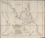
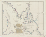
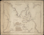
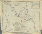
Map Summary Maritime Portion of South Australia
This map was not included in the first edition of Arrowsmith's London Atlas issued in 1834. It appeared in Arrowsmith's 1838 edition, the fourth Australian plate to be added to the existing 50 plates of the first edition, which included three Australian titles. The Maritime Portion of South Australia if it had been numbered would have been plate [54].
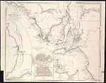
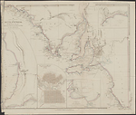
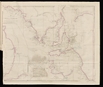
It has an apt title for a map that features only part of the coastal fringe of a most arid area. The main map is based on Flinders' (Flinders, 1802) coastal survey but at a reduced scale. It extends from the Nuyts Archipelago at longitude 133° to 141°East, the border with the present day state of Victoria.
The focus of the map is the two gulfs of Spencer and St Vincent and the Fleurieu Peninsula east of St Vincent's Gulf. The empty ocean space south of the main map was filled with a number of inset maps showing a town plan of Adelaide, the capital city, and an inset of its immediate hinterland. Two further insets of harbours on the south-east coast at Encounter Bay and at Nepean Bay on Kangaroo Island complete the map. Encounter Bay was the point where the chance meeting between the two commanders of voyages of discovery, Matthew Flinders, the English commander and Nicholas Baudin the French commander occurred.
The map was issued between the dates June 1838 and June 1841, a span of only three years. There was however a prototype issued in May 1838, a description of which will be found under 'A new map of South Australia'. However any issues later than February 1840 have no additional information added to the map and are mainly reprints. Seven states of the map have been distinguished, the last two of which were also used in Parliamentary Reports produced by the Select Committee on South Australia (Reports from the Select Committee on South Australia , 1841).
This map appears in issues of the London Atlas until 1858 when it is replaced by a new map of South Australia entitled, South Australia shewing the division into counties of the settled portions of the Province from the surveys of Captn. Frome, Rl. Engrs., Survr. Genl. Of the Colony. The map is also found in the positions of plates [60], [61] and [67] of the Atlas.
Related entries
Published resources
Books
- Flinders, Matthew, A voyage to Terra Australis : undertaken for the purpose of completing the discovery of that vast country, and prosecuted in the years 1801, 1802, and 1803, in His Majesty's ship the Investigator. Atlas, G. and W. Nicol, London, 1814. Details
Reports
- Great Britain. Parliament. House of Commons. Select Committee on South Australia, Second report from the Select Committee on South Australia : together with the minutes of evidence, appendix, and index, Ordered by the House of Commons to be printeed, 10 June 1841, London, 1841. Details
Images
- Title
- Maritime Portion of South Australia, 1838/2
- Type
- Map
- Repository
- National Library of Australia Map Collection
- Title
- Maritime Portion of South Australia, 1839/1
- Type
- Map
- Repository
- National Library of Australia Map Collection
- Title
- Maritime Portion of South Australia, 1839/2
- Type
- Map
- Repository
- National Library of Australia Map Collection
- Title
- Maritime Portion of South Australia, 1839/3
- Type
- Map
- Repository
- National Library of Australia Map Collection
- Title
- Maritime Portion of South Australia, 1840/1
- Type
- Map
- Repository
- National Library of Australia Map Collection
- Title
- Maritime Portion of South Australia, 1841/1
- Type
- Map
- Repository
- National Library of Australia Map Collection
- Title
- Maritime Portion of South Australia, 1841/2
- Type
- Map
- Repository
- The University of Melbourne Library, Special Collections
Dorothy F. Prescott
Created: 9 September 2010, Last modified: 20 September 2019