
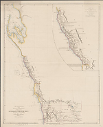
Map State Australia, From Swan River to Shark Bay 1840/1
Australia, from Swan River to Shark Bay embracing Australind with Port Grey from the surveys of Captn. Grey and other official documents / drawn by John Arrowsmith. Scale [ca. 1:1,600 000] 1in. = 25 miles. London, Pubd. 21st Novr. 1840, by John Arrowsmith, 10 Soho Square.-- 2 maps on sheet 64.0 x 49.5cm., in pocket.
With:
The country from Gantheaume Bay to the River Arrowsmith on the scale of original survey of Captn. Grey. Scale [ca.1:950 000 calculated on 1 degree of latitude].
S 27° 40'-S 29° 40'/ E 114° - E 115° 30'.
SHEET EXTENT:
S 24°05--S 32°10'/E 112°35'--E 120°
Description
Shows
TITLE:
This is the first state of the map its title being used as the subtitle of one published the following year, i.e. 1841 with the title Map and chart of the west coast of Australia; from Swan River to Shark Bay including Houtman's Abrolhos and Port Grey from the surveys of Capts. Grey, Wickham, King and from other official documents / drawn by John Arrowsmith which see its title being used as the amended sub title.
COUNTIES:
MELBOURNE, GLENELG, GREY, CARNARVON, TWISS, VICTORIA, DURHAM, LANSDOWNE, PERTH, YORK, HOWICK and BEAUFORT
DISTRICTS:
VICTORIA
EXPLORERS' ROUTES:
George Grey
HYDROGRAPHIC SURVEY:
Phillip Parker King.
REFERENCE:
Not in Tooley
NOTES
The states of the map are basically the same with the removal in the second state of the word 'Australind' from the phrase 'Australind & Port Grey'. This was an error on Arrowsmith's part as the location of Australind is just north of the present day Bunbury.' This means that it does not appear on this map as it lies south of the present limits of this map.
The second state has however several additional insets of harbours.
The main chart extends from the settled parts in the south of Western Australia to north of Shark Bay. In its middle latitudes it shows exploration for a short distance inland. North of 27°50'S only coastal detail shown until the Gascoyne River is reached at 24°50'S.
The area from 27°40'S to 29°30'S has been given the district name of VICTORIA.
The inset map on a larger scale is a copy of Grey's original traverse and much greater detail of topography is given.
Key Dates
- 1837 - 1840
- Situation date
- 21 November 1840
- Map Publication Date
Related entries
Timeline
Australia, From Swan River to Shark Bay 1840/1
Map and Chart of the West Coast of Australia 1841/1
Institutional and Other Holdings
Mitchell Map Collection, State Library of New South Wales
- Australia, from Swan River to Shark Bay embracing Australind with Port Grey [cartographic material] / John Arrowsmith., 1840, ZMC 851.3/1840/1; Mitchell Map Collection, State Library of New South Wales. Details
National Library of Australia Map Collection
- Australia, from Swan River to Shark Bay embracing Australind with Port Grey [cartographic material] : from the surveys of Capt.n Grey, and other official documents / drawn by John Arrowsmith, 1840, MAP RM 1185; National Library of Australia Map Collection. Details
Royal Geographical Society
- Australia, from Swan River to Shark Bay, Embracing Australind with Port Grey; from the Surveys of Captn. Grey, and other Official Documents, 1840, mr Australia D.204; Royal Geographical Society. Details
Published resources
Books
- Tooley, Ronald Vere, The mapping of Australia and Antarctica, Holland Press, London, 1985, 649 pp. Details
Images
- Title
- Australia, From Swan River to Shark Bay 1840/1
- Type
- Map
- Repository
- National Library of Australia Map Collection
Dorothy F. Prescott
Created: 9 September 2010, Last modified: 13 March 2013