
Map State Cockburn Sound, 1840/1
Cockburn Sound / by J.S. Roe, Esqr., Survr. Genl.. of the Colony of Western Australia.
With: King Georges Sound with its harbours; from Captn. Flinders' Survey, (1802) improved by documents in the Colonial Office to 1833.
Scale 1 in. = 1.5 nm. [ca.1: 110,000].
London, Pubd. Jany. [space] 1840, by J. Arrowsmith, 10 Soho Square.
2 maps on 1 sheet : mounted on linen, col. ; 28.5 x 31.0 cm. and 23 x 31 cm.
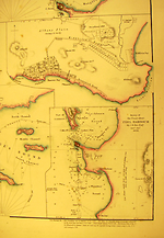
Inset: Kingstown (in Rottnest Island). Scale 1" = 40 chains. [ca. 1: 31 680].
See KING GEORGES SOUND for a description of the lower chart on this sheet
Description
Shows:
TITLE:
The title reverts to Cockburn Sound. - King Georges Sound.
Top left hand side of sheet. Beneath this is found the scale and details of tides.
Then a paragraph follows beneath the scale of nautical directions. Beneath the first title on this sheet, i.e. Cockburn Sound, is a further paragraph headed Additional Instructions, by His Excellency Sir Jas. Stirling, Captn. R. N' which gives further details of winds in various seasons, and instructions for entering Cockburn Sound and Gage Road
PLATE NO:
35a
The Library of Congress records this as a loose sheet [Pl. 35a] in their atlas dated 1840 (Phillips, item 4322)
IMPRINT:
The imprint now reads London, Pubd. Jany. [space] 1840, by J. Arrowsmith, 10 Soho Square.
INSET:
Kingstown: Shows Kingstown on Rottnest Island.
Kingstown has added in parentheses (in Rottnest I.) A linear scale has been added.
1" = 40 chains.
The salt lagoon west of Kingstown now names Sealer Lake and Threefold Lake. Land holdings below Sealer Lake appear in the name of R & C. Thomson. On the west coast of Sealer Lake a holding for F. H. Byrne. The cove north of Sealer Lake named Filter Cove. To the south of the town Lookout Hill named.
INSET:
Peel Harbour: Survey of the coast about Peel Harbour by J. S. Roe …1838.
MARGIN:
In the margin beneath this last inset is a three-line description of winds and tides in Peel Harbour.
REFERENCE
Not in Tooley
NOTES
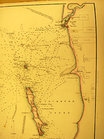
The chart extends from the mouth of the Swan River south to Cape Peron and includes the waters west of Gage Roads and Garden Island.
On the coast of the mainland in Cockburn Sound the site of Clarence has been changed from the previous version. It is now shown further north in the hinterland of Woodman's Spit & Pt. fronting onto Jervoise Bay. At the lower right hand side beneath Cape Peron Bird Is named. More soundings appear north-east of the Southern Flats. On the mainland landholdings are shown at Brown Hill in the names of T. Peel, and further inland, in the names of R.G. Meares and T. Watson. Behind these names printed in the margin parallel to the neat-line are the names Thomas Peel and George Dunnage. Further north landholdings are shown for W. Ledyard, J. W. Davey, H. F. Hall, C. Macfaull, J. Henty, G. Robb, W.H. Smithers, T. Harrison and R. Lewis.
Changes AND ADDITIONS
TITLE:
The title is as the 1833/1 state
PLATE NO:
35a.
The Library of Congress Cockburn Sound Plate 35a described in their catalogue entry as a loose sheet inserted into their atlas dated 1840. (Phillips, item 4322)
IMPRINT:
London, Pubd. Jany [space] 1840, 10 Soho Square
INSET:
Kingstown:
The salt lagoon west of Kingstown now names Sealer Lake and Threefold Lake. Land holdings below Sealer Lake appear in the name of R & C. Thomson. On the west coast of Sealer Lake a holding for F. H. Byrne. The cove north of Sealer Lake named Filter Cove. To the south of the town Lookout Hill named.
INSET:
Survey of the coast about Peel Harbour by J. S. Roe …1838.
MARGIN:
In the margin beneath this last inset is a three-line description of winds and tides in Peel Harbour.
NOTES
At the lower right hand side beneath Cape Peron Bird Is named. More soundings appear north east of the Southern Flats. On the mainland land holdings are shown at Brown Hill in the names of T. Peel, further inland, R.G. Meares and T. Watson. Behind these names printed in the margin parallel to the neatline are the names Thomas Peel and George Dunnage. The site of Clarence is shown in a different position compared with the previous state of this chart. In this version it is shown in the hinterland of Woodman's Spit & Pt. fronting onto Jervoise Bay. Further north landholdings are shown for W. Ledyard, J. W. Davey, H. F. Hall, C. Macfaull, J. Henty, G. Robb, W.H. Smithers, T. Harrison and R. Lewis.
Key Dates
- 1826 - 1839
- Situation date
- January 1840
- Map Publication Date
Institutional and Other Holdings
Library of Congress, Geography and Map Division
- The London Atlas of Universal Geography, exhibiting the physical & political divisions of the various countries of the world, constructed from original materials, 1840, G1019 .A8 1840 Vault fol. Copy 1; Library of Congress, Geography and Map Division. Details
Published resources
Books
Images
- Title
- Cockburn Sound, 1840/1
- Type
- Map
- Repository
- Library of Congress, Geography and Map Division
- Title
- Inset maps of Albany and Peel Harbour
- Type
- Map
- Repository
- Library of Congress, Geography and Map Division
Dorothy F. Prescott
Created: 4 August 2010, Last modified: 6 March 2013