
Map State The Colony of Western Australia, 1843/1
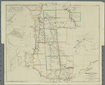
The Colony of Western Australia; from the surveys of John Septimus Roe, Esqr. , Surveyor Genl. and from other Official Documents in the Colonial Office and Admiralty, compiled by John Arrowsmith. [Pl.] 36. Scale [ca. 1:970 000 at 35°S]. S 30° 57'-S 35° 07'/E 113° 40'-E 120° 03'. London, Pubd. Jany. 2nd 1843 by J. Arrowsmith, 10 Soho Sq.
1 map : col ; 50.0 x 61.0 cm.
Insets: Guildford, [Perth region], Kelmscott, Augusta, Perth, Fremantle
Description
Shows 26 counties in the south-western portion of the Colony with explorers' tracks and profuse notes on landscape and vegetation. Some landholders identified.
PLATE NO:
36
IMPRINT:
The imprint now reads London, Pubd. Jany. 2nd 1843 by J. Arrowsmith, 10 Soho Sq.
INSETS:
Guildford, [Perth region], Augusta, Kelmscott, Perth, Fremantle
Guildford
North-east of Perth shows landholders W. Tanner and J. Stirling north of the Swan River and to the west of the Swan, W. Tanner, S. Dodds, F. H. Byrne, Capt. Picking and N. S. Talbot. The Helena River flows into the Swan from the east. Public buildings and streets named.
[Perth region]
Extends from north of Guildford south to Cockburn Sound and east to Kelsmcott.
Shows the Swan, Helena and Canning rivers and surveyed allotments. Some landholders' names appear.
Augusta
Plan of the town at the mouth of the Blackwood River land allotments shown fronting Flinders Bay.
Kelmscott
Plan of the settlement shown on the right bank of the Canning River with allotments laid out along the river bank.
Perth
Town plan shows allotments fronting the Swan River. St Georges Terrace named. Large areas of swamps behind the front streets overlie allotments. To the east along the right bank of the Swan are land holdings in the names of P. Brown, W. T. Graham, A. H. Stone, W. B. Andrews and P. Wicks. A burial ground is marked east of the town.
Fremantle
Town plan with streets and land allotments laid out and public areas designated.
COUNTIES:
MELBOURNE, GLENELG, GREY, CARNARVON, LANSDOWNE, DURHAM, VICTORIA, TWISS, PERTH, YORK, HOWICK, BEAUFORT, MINTO, GRANTHAM, MURRAY, WELLINGTON, WICKLOW, PEEL, HAY, GODERICH, NELSON, SUSSEX, LANARK, STIRLING, PLANTAGENET AND KENT
EXPLORERS' ROUTES:
New routes added are A[lexander] Collie up Swan and tributary, G[eorge] F[letcher] Moore, G. F. Moore and Brown [Peter Broun], J[ohn] S[eptimus] Roe north of Albany, J. S. Roe from York, Lt. [Henry William St Pierre] Bunbury, A[lfred] Hillman from Pinjarra, A. Hillman west from Albany, Lt. W[illiam] Preston from Augusta. The supposed track of convicts has been removed. Earlier routes that do not appear in these notes are described in the Notes of Discoveries in Western Australia
Reference
T129
NOTES
The first issue of The Colony of Western Australia is a remodelled Discoveries map, which was the earlier state of the map. It has been extensively revised and includes many new place names including places such as Rockingham, Pinjarra, Picton, Bunbury and Busselton on the west coast. On the south coast Normalup, Rame Hd., Irwin Inlet, Dillon Bay, Bremer Bay and Pt. Hood among others. New rivers flowing to the sea are the Lennox, Vasse and Capel into Geographe Bay and the estuary of an un-named river east of Pt. Knob. Rugged ranges north of Abany are now named the Stirling Ranges.
The coast line has been greatly altered and many new features are named.
Land allotments appear in the Swan, Avon and Toodyoy valleys, near Pinjarra and the Murray River, on the west coast at Busselton and near Picton, Waterloo and Williamsburg. Other blocks are shown near Albany and Wyndham and in the Vale of Kalgan.
New discoveries include the tracks of A. Collie in 1832 up a tributary of the Swan River and back via the Swan, this possibly being an examination of the 1500 acres granted to him.
G. F. Moore's May 1836 explorations are shown north from Guildford to the Moore R. then south-west following the river and thence south-east back to Guildford. A second exploration is shown north-east of Guildford to Northam and beyond with Brown [Peter Broun] in 1836.
J. S. Roe's journey is shown from Albany west and then north-east before turning north-west in Nov and Dec.1835. Pushing inland J. S. Roe's track appears Oct/Nov 1836 east of Perth from York to the Glenelg Hills thence north to latitude 31°45'S and from thence westwards to the Moore R and thence southward to Guildford.
Tracks of Lt. Bunbury in Oct 1836 between Beverley and Williamsburg are shown.
A. Hillman's tracks from Pinjarra on the west coast eastwards to Williamsburg in January 1835 appear, and his route west of Albany towards Pt Nuyts in July 1833.
Lt. W. Preston's track is shown from Augusta to the north in vicinity of Vasse Inlet in 1831.
The supposed track of convicts overland from Albany to Geographe Bay has been removed.
There are no changes to the map content for any of the 1839 imprints.
In the 1843/1 state of the map the previously un-named river west of Kojanup (33°50'S/ 117°09'E) is now called Balgarup R. Kinnunup appears on Roe's 1835 north/south return track. A. Hillman's track completed from north of Williamsburg returning to Pinjarra in Oct 1835.
A. Collie's April 1831 exploration shown by a loop north-west of Wyndham and north of the Vale of Kalgan.
L. Preston appears on the coast north of the County of Wellington. The outline of Australind is shown west of Waterloo on the Leschenault Inlet. The R. Preston which drains the Henty Plains now shown as the most southerly of three streams flowing north-west to Picton (previously the next most northerly had carried this name). Dalyellup appears on the coast near Picton and Bunbury's Ford further south.
Stirling and Roe's journey down the west coast between Peel Inlet and Vasse Inlet marked.
The course of the R. Capel is changed. New mid sections of other rivers in this vicinity appear. A track from Vasse Inlet marked going east to Henty Plains and then north-west to Bunbury is shown.
Also an undated track is shown for Sir James Stirling just south of Bunbury.
CHANGES AND ADDITIONS
Considerable changes occur.
IMPRINT:
The imprint date now reads Jany. 2nd 1843.
EXPLORERS ROUTES:
There are new explorations by J. S. Roe, A. Hillman, A. Collie, Lt. Preston and James Stirling.
NOTES:
The previously un-named river west of Kojanup (33°50' S/ 117°09'E) now called Balgarup R. Kinnunup appears on Roe's 1835 north/south return track. A. Hillman's track completed from north of Williamsburg returning to Pinjarra in Oct 1835.
A. Collie's April 1831 exploration shown by a loop north-west of Wyndham and north of the Vale of Kalgan.
L. Preston appears on the coast north of the County of Wellington. The outline of Australind is shown west of Waterloo on the Leschenault Inlet. The R. Preston which drains the Henty Plains now shown as the most southerly of three streams flowing north-west to Picton (previously the next most northerly had carried this name). Dalyellup appears on the coast near Picton and Bunbury's Ford further south.
Stirling and Roe's journey down the west coast between Peel Inlet and Vasse Inlet marked.
The course of the R. Capel is changed. New mid sections of other rivers in this vicinity appear. A track from Vasse Inlet marked going east to Henty Plains and then north-west to Bunbury is shown.
Also an undated track is shown for Sir James Stirling just south of Bunbury.
Key Dates
- 1829 - 1842
- Situation date
- 2 January 1843
- Map Publication Date
Related entries
Timeline
Discoveries in Western Australia, 1833/1
Discoveries in Western Australia, 1833/2
Discoveries in Western Australia, 1833/3
Discoveries in Western Australia, 1833/4
Discoveries in Western Australia, 1833/5 (1834)
Discoveries in Western Australia, 1833/6 (1838/1)
Discoveries in Western Australia, 1833/7 (1838/2)
The Colony of Western Australia, 1839/1
The Colony of Western Australia, 1839/2
The Colony of Western Australia, 1839/3
The Colony of Western Australia, 1839/4 (1842/1)
The Colony of Western Australia, 1843/1
The Colony of Western Australia, 1856/1 (no date)
The Colony of Western Australia, 1856/2
The Colony of Western Australia, 1863/1
Institutional and Other Holdings
British Library Map Library
- The London Atlas of Universal Geography ... by ... John Arrowsmith, Cartographic Items Maps 41.f.8; British Library Map Library. Details
Cambridge University Library
- The London Atlas of Universal Geography : by his much obliged and humble servant John Arrowsmith., 1842, Atlas.2.84.13; Cambridge University Library. Details
- The London Atlas of Universal Geography : exhibiting the physical & political divisions of the various countries of the world, constructed from original materials., 1842, Atlas.2.84.9; Cambridge University Library. Details
Library of Congress, Geography and Map Division
- The London Atlas of Universal Geography, 1842, G1019 .A8 1842b fol. Copy 1; Library of Congress, Geography and Map Division. Details
- The London Atlas of Universal Geography, 1842, G1019 .A8 1842c fol. Copy 1; Library of Congress, Geography and Map Division. Details
- The London Atlas of Universal Geography, exhibiting the physical & political divisions of the various countries of the world, constructed from original materials, G1019 .A8 1842 fol. Copy 1; Library of Congress, Geography and Map Division. Details
National Library of Australia Map Collection
- The Colony of Western Australia [cartographic material] : from the surveys of John Septimus Roe Esqr. Surveyor Genl. and from other official documents in the Colonial Office and Admiralty / compiled by John Arrowsmith, 1843, MAP RM 2657; National Library of Australia Map Collection. Details
- The Colony of Western Australia [cartographic material] : from the surveys of John Septimus Roe Esqr. Surveyor Genl. and from other official documents in the Colonial Office and Admiralty / compiled by John Arrowsmith, MAP T 129; National Library of Australia Map Collection. Details
Queen's College, Oxford
- The London Atlas of Universal Geography, : exhibiting the physical & political divisions of the various countries of the world, constructed from original materials. / By ... John Arrowsmith, 1842, 14.G.1; Queen's College, Oxford. Details
State Library of Western Australia
- The Colony of Western Australia [cartographic material] : from the surveys of John Septimus Roe Esqr. Surveyor Genl. and from other official documents in the Colonial Office and Admiralty / compiled by John Arrowsmith., 1843, 24/5/11 (1843) RARE; State Library of Western Australia. Details
The University of Melbourne Library, Special Collections
- The London atlas of universal geography : exhibiting the physical & political divisions of the various countries of the world, UniM Bail SpC/BX ef 912 A779; The University of Melbourne Library, Special Collections. Details
Published resources
Books
- Tooley, Ronald Vere, The mapping of Australia and Antarctica, Holland Press, London, 1985, 649 pp. Details
Images
- Title
- The Colony of Western Australia, 1843/1
- Type
- Map
- Repository
- National Library of Australia Map Collection
Dorothy F. Prescott
Created: 3 August 2010, Last modified: 3 July 2012